
Post-tropical cyclone Teddy forecast to produce destructive waves, heavy rain and strong winds across Nova Scotia, Canada
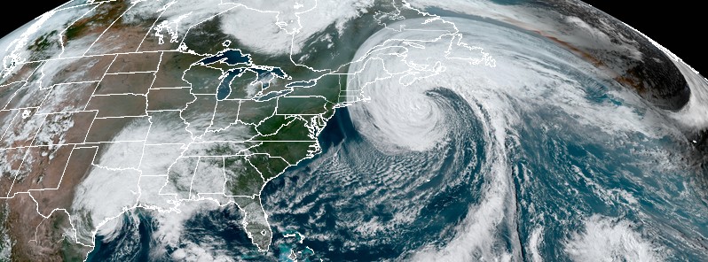
Image credit: NOAA/GOES-16, RAMMB/CIRA. Acquired at 19:00 UTC on September 22, 2020
Hurricane "Teddy" has transitioned into a strong post-tropical cyclone and is now approaching Nova Scotia, Canada, producing destructive waves, heavy rain, and strong winds.
- Landfall is expected over eastern Nova Scotia today.
- Teddy's center will then move near or over Newfoundland and be east of Labrador by September 24.
- A Tropical Storm Warning is in effect for the south coast of Nova Scotia from Digby to Meat Cove, and Port aux Basques to Francois, Newfoundland.
- A Tropical Storm Watch is in effect for Meat Cove to Tidnish, Nova Scotia; North of Digby to Fort Lawrence, Nova Scotia; Magdalen Islands Quebec; and Prince Edward Island.
At 06:00 UTC on September 23, Teddy's center was located about 135 km (85 miles) S of Halifax, Nova Scotia, and 575 km (355 miles) SW of Port Aux Basques, Newfoundland, Canada.
It had maximum sustained winds of 120 km/h (75 mph) and minimum central pressure of 955 hPa.
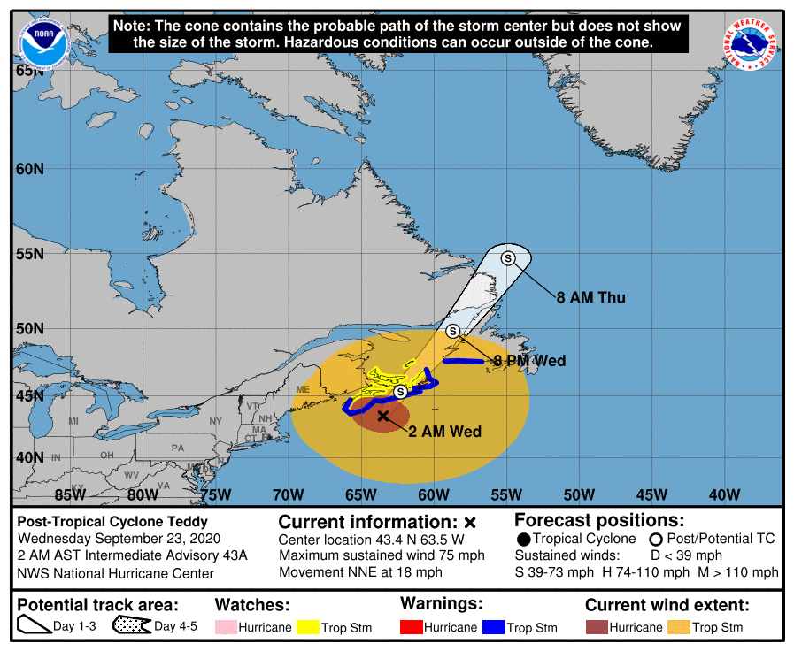
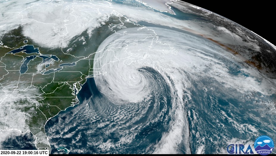
Image credit: NOAA/GOES-16, RAMMB/CIRA
The storm was moving NNE at 30 km/h (18 mph) and this general motion is expected to continue for the next day or so, according to the NHC.
On the forecast track, Teddy's center will move over eastern Nova Scotia today, and then near or over Newfoundland by tonight (AST), and be east of Labrador on Thursday, September 24.
Although additional weakening is expected today, this should still be a strong post-tropical cyclone when it moves near and over Nova Scotia.
A dangerous storm surge is expected to produce significant coastal flooding near and to the east of where the center makes landfall in Nova Scotia. Near the coast, the surge will be accompanied by very large and destructive waves.
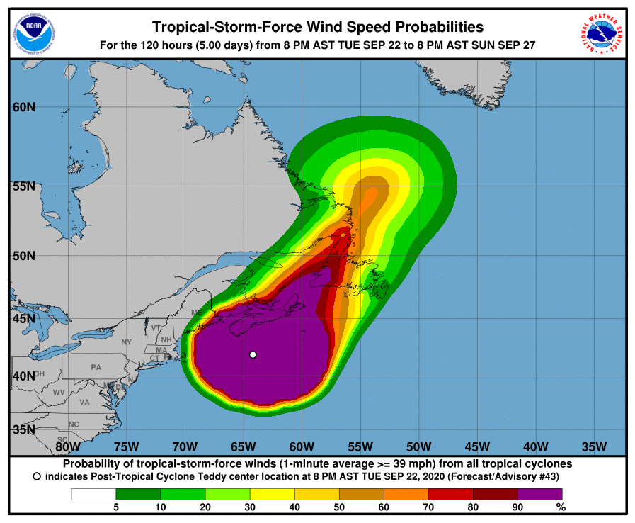
Large swells generated by Teddy are affecting Bermuda, the Lesser Antilles, the Greater Antilles, the Bahamas, the east coast of the United States, and Atlantic Canada. These swells are likely to cause life-threatening surf and rip current conditions.
Tropical storm conditions are occurring in the Nova Scotia warning area and are expected to begin in the watch areas this morning (AST). Tropical storm conditions are expected to begin in the Newfoundland warning area this afternoon.
Through Thursday, Teddy is expected to produce rainfall accumulations of 50 – 100 mm (2 to 4 inches) with isolated totals of 150 mm (6 inches) across sections of Atlantic Canada.
Heavy rain with accumulation up to 100 mm (4 inches), sustained high winds of 90 km/h (55 mph), and gusts up to 120 km/h (75 mph) are expected to continue overnight into Wednesday, Halifax Regional Municipality warned.
"This storm is moving slowly, meaning severe weather conditions are expected to continue impacting the region over the next 12 to 24 hours. The peak period of the storm – bringing the most significant impacts – is forecasted to occur between 6-7 a.m. on Wednesday [September 23].
"High storm surges are expected, and all residents should stay away from all areas of the coast or any low-lying areas, including the waterfronts in downtown Halifax and Dartmouth. Be ready to move inland or to higher ground.
"The public is urged to stay off the roads for their own safety and avoid impeding efforts by first responders in emergency situations."
I'm a dedicated researcher, journalist, and editor at The Watchers. With over 20 years of experience in the media industry, I specialize in hard science news, focusing on extreme weather, seismic and volcanic activity, space weather, and astronomy, including near-Earth objects and planetary defense strategies. You can reach me at teo /at/ watchers.news.
Commenting rules and guidelines
We value the thoughts and opinions of our readers and welcome healthy discussions on our website. In order to maintain a respectful and positive community, we ask that all commenters follow these rules.