
Major stratospheric warming developing over the Arctic, ensemble data indicate a polar vortex split around February 15
A strong stratospheric warming event is underway over the Arctic in early February 2026, rapidly weakening the Northern Hemisphere polar vortex. Forecasts indicate stratospheric westerly wind reversal and vortex split around mid-February, with cores separating further later.
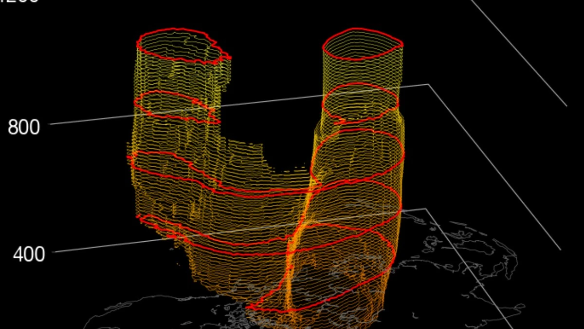
GFS Stratospheric Polar Vortex Structure valid at 00:00 UTC on February 15, 2026. Credit: Stratobserve
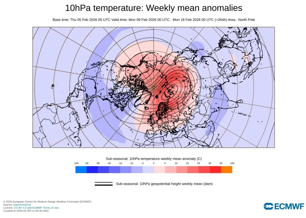
A strong sudden stratospheric warming (SSW) event began developing in early February 2026, producing rapid temperature increases and decelerating the zonal-mean westerly winds in the mid-to-upper stratosphere.
Temperature anomalies of around +40°C (+104°F) have been analyzed near 10 mb (≈ 30 km / 18.6 miles) altitude over several days, meeting the established criteria for a major warming event once full wind reversal is confirmed by monitoring agencies.
Following this warming, the polar vortex has weakened substantially and become elongated and asymmetric, indicating strong wave–mean-flow interaction. Ensemble guidance shows the disrupted vortex evolving toward a split structure by mid-February.
According to analysis by Andrej Flis of Severe Weather Europe, ensemble forecasts from the European Centre for Medium-Range Weather Forecasts (ECMWF) indicate that the polar vortex will likely split into two lobes around mid-February 2026, with one displaced toward Eurasia and the other toward North America.
Model forecasts valid around 00:00 UTC on February 15 show two distinct lobes: one displaced over northern Eurasia and the other extending toward northeastern Canada and Greenland.

Large-scale circulation analyses show intense upward-propagating planetary waves entering the stratosphere during late January and early February. The strongest activity originated over the North Pacific and western North America, where persistent tropospheric ridging enhanced meridional flow and supported vertical wave propagation into the polar stratosphere.
As the waves broke aloft, they decelerated and began reversing the polar night jet, producing rapid adiabatic warming through subsidence over the polar cap.
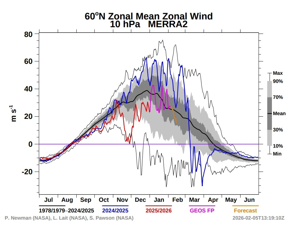
Zonal-mean wind analyses near 60° N and 10 hPa show a transition from strong westerlies toward easterlies during the first week of February, consistent with the threshold for a major SSW as defined by the World Meteorological Organization (WMO) and NOAA Climate Prediction Center (CPC). Analyses are based on NASA GSFC / MERRA-2 data sets (P. Newman, L. Lait, S. Pawson).
Circulation anomalies are descending through the lower stratosphere, indicating active stratosphere–troposphere coupling. Height and wind anomalies are forecast to propagate downward over the next one to two weeks, increasing the likelihood that the current stratospheric disturbance will influence tropospheric circulation rather than remain confined to upper levels.
In typical SSW scenarios, the weakened polar vortex allows cold polar air to extend southward as the stratospheric signal reaches the troposphere over several weeks. The process often coincides with a negative phase of the Arctic Oscillation (AO), which increases the probability of cold-air intrusions into the mid-latitudes. However, such outcomes remain statistical tendencies rather than guarantees.
Forecast confidence for the February 2026 event is reduced by the presence of tropical-atmosphere interference, particularly from the Madden–Julian Oscillation (MJO).
Current outlooks show an active MJO phase likely to modify planetary-wave patterns in the troposphere and temporarily limit vertical coupling between the stratosphere and surface. This interaction could delay or weaken the typical post-SSW cold response across North America and Europe until late February, when models suggest the coupling may re-establish.

I am an Assistant Editor and Severe Weather & Science Journalist at The Watchers, specializing in real-time severe weather coverage, geophysical event reporting, and research-driven scientific analysis. You can reach me at rishav(at)watchers(.)news.
i’d be interested in hearing about any correlation between these stratospheric anomalies and the large number of solar flares we’ve been seeing recently….there’s certainly been some coincidence…
Funny how we can’t just have a cold spell any more and call it that. And it has to come at the cost of heating and splitting of the polar vortex. Ionosphere heater.. microwaves used to heat and lift the atmosphere and break up the polar vortex.
I really wish that you would speak so us regular folks could understand what you meant. Go ahead & speak scientifically, but please be kind and just explain in reasonable terms, so the rest of us can know what you meant.