
Tropical Cyclone Rusty left flooded rivers and lakes in north-western Australia
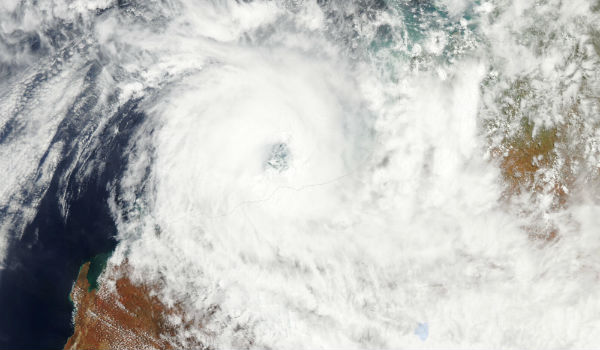
Featured image: Aqua/MODIS satellite captured Tropical Cyclone Rusty on February 26, 2013 (Credit: LANCE/MODIS)
Tropical Cyclone Rusty made landfall in northwestern Australia in late February 2013, coming ashore east of Port Hedland and bringing strong winds to the community of Pardoo. Rusty’s heavy rainfall forced Australian Bureau of Meteorology to issue a flood warning for the catchment of the De Gray River on March 4, 2013.
Flooded rivers typically carry heavy loads of sediment, and a sediment plume appeared at the river mouth on March 3/4, 2013. MODIS on NASA’s Aqua satellite captured natural-color imagery of the sediment plume on March 3.
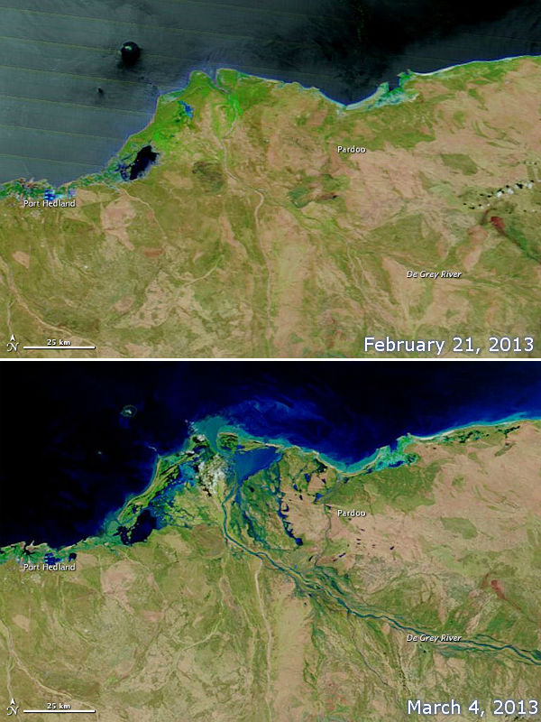 Moderate Resolution Imaging Spectroradiometer (MODIS) on NASA’s Terra satellite captured De Grey River and its delta – the top image shows conditions observed before the storm, on February 21, 2013 and the bottom image was captured on March 4, 2013. (NASA images courtesy LANCE MODIS Rapid Response. Caption by Michon Scott)
Lake Disappointment also underwent a significant transformation, thanks to heavy rains from Tropical Cyclone Rusty. It is a large, saline lake in the Gibson Desert of northwestern Australia. Although the lake is salty, Lake Disappointment provides a refuge for many species of waterfowl. Rainfall also prompts rapid growth of vegetation in this usually arid region.
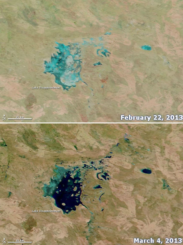 The Moderate Resolution Imaging Spectroradiometer (MODIS) on NASA’s Terra satellite captured the bottom image on February 22, 2013 and the top image on March 4, 2013. (NASA images courtesy LANCE MODIS Rapid Response. Caption by Michon Scott)
Water depths increased also in other regional water bodies after Cyclone Rusty’s rains.
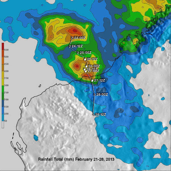 Rainfall totals in association with tropical cyclone Rusty are shown for the period from February 21-28, 2013. Rusty’s approximate 00:00 UTC and 12:00 UTC positions are shown overlaid in white. This analysis indicates that the heaviest rainfall of close to 600mm (~23.6 inches) fell in the Indian Ocean off the Australian Coast but rainfall totals of over 500mm (~19.7 inches) are also shown along the coastal area where Rusty made landfall. This analysis shows that Rusty also spread rainfall totaling over 50mm (~2 inches) far inland from the center of the tropical cyclone’s circulation. (Credit: NASA/TRMM)
Sources: Earth Observatory, Australian Bureau of Meteorology, Tropical Rainfall Measuring Mission (TRMM)
Commenting rules and guidelines
We value the thoughts and opinions of our readers and welcome healthy discussions on our website. In order to maintain a respectful and positive community, we ask that all commenters follow these rules.