
Devil’s Lake continues to grow
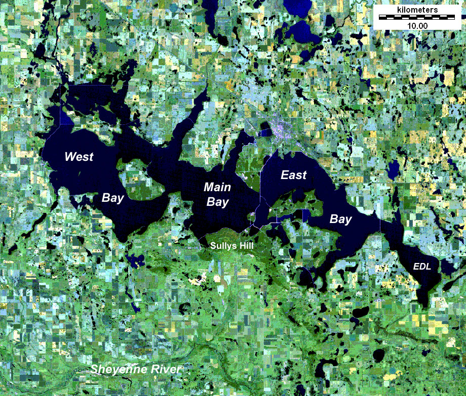
Image credit: TW
Devils Lake, North Dakota is a “a slow-growing monster: a huge lake that has steadily expanded over the last 20 years, swallowing up thousands of acres, hundreds of buildings and at least two towns in its rising waters.
The water level of Devil’s Lake has risen about 8 meters since 1993 and is still rising. Lake levels were near 442 meters two years ago. The lake recently started overflowing into neighboring Stump Lake, and there is a slight chance that it may eventually spill into a nearby river, something that hasn’t happened for 2000 years.These are near-record levels.


On May 5, 2010, accuweather.com reported that Devils Lake had reached a depth of 443 meters, surpassing record levels. Today is even deeper. According to Louise Oleson, editor of the Devils Lake Journal, “Devils Lake continues to rise to record levels.”
Devils Lake stood at 443,5 meters at last measuring. The road heading to the Norway Lutheran Church graveyard north of Highway 19 at the Grahams Island Road was impassable and guarded by a flock of geese. A subdivision north of Fargo has become an island retreat for a third straight spring. Overland flooding from the Sheyenne River has cut off access by roads from the north, south and west.
Reaching its greatest extent around 13,000 years ago, Lake Agassiz was an immense glacial lake larger than all five Great Lakes combined, and held more water than is contained by all lakes in the world today.
Devil’s Lake is part of what used to be the south west side of Lake Agassiz. It’s certainly beginning to look as if Glacial Lake Agassiz could indeed be recharging itself.
Interactive map of Devils Lake, ND

Period of Record Graph for Devils Lake near Devils Lake
Devils Lake BASIN DATA
The Devils Lake Basin is a 3,810-square-mile subbasin in the Red River of the North Basin. At an elevation of about 1,447 feet above sea level, Devils Lake begins to spill into Stump Lake; and at an elevation of about 1,459 feet above sea level, the combined lakes begin to spill through Tolna Coulee into the Sheyenne River.
Since the end of glaciation about 10,000 years ago, Devils Lake has fluctuated between spilling and being dry. Research by the North Dakota Geological Survey indicates Devils Lake has overflowed into the Sheyenne River at least twice during the past 4,000 years and has spilled into the Stump Lakes several times (Bluemle, 1991; Murphy and others, 1997). John Bluemle, North Dakota State Geologist, concluded the natural condition for Devils Lake is either rising or falling, and the lake should not be expected to remain at any elevation for a long period of time.

The potential for a catastrophic spill from the natural outlet to the Sheyenne River poses a threat for downstream interests. If Devils Lake reaches the spill elevation (about 1,459 feet above sea level), the contributing drainage area of the Sheyenne River near Cooperstown, North Dakota, will quadruple (from 1,270 square miles to 5,070 square miles) because the entire Devils Lake Basin then would contribute flow to the Sheyenne River. Also, water in Stump Lake (which becomes part of Devils Lake at an elevation of about 1,447 feet above sea level) is of much poorer quality than water in western Devils Lake, and significant volumes of water spilling from the natural outlet would cause serious downstream water-quality problems.

About 5 percent of the landmass of North America drains into terminal lakes, which are lakes that are located at the lowest point within a closed drainage basin. Closed drainage basins have no outlet to the oceans. The advance and retreat of continental glaciers shaped the landscape of all of North Dakota east and north of the Missouri River. Thousands of closed drainage basins were formed in North Dakota as a result of glaciation. Terminal lakes located in these closed drainage basins range in size from a few acres to more than 50,000 acres.
Since the end of glaciation about 10,000 years ago, Devils Lake has fluctuated between spilling and being dry. Research by the North Dakota Geological Survey indicates Devils Lake has overflowed into the Sheyenne River at least twice during the past 4,000 years and has spilled into the Stump Lakes several times (Bluemle, 1991; Murphy and others, 1997). John Bluemle, North Dakota State Geologist, concluded the natural condition for Devils Lake is either rising or falling, and the lake should not be expected to remain at any elevation for a long period of time. (USGS)


Lord Agassiz commented on The Watchers:
So my lake is filling up again…alright!!!