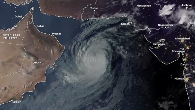
2019 North Indian Ocean cyclone season breaks named storm days record

2019 North Indian Ocean cyclone season breaks named storm days record

The Arabian Sea witnessed a rare simultaneous formation of two tropical cyclones – Kyarr on October 24 and Maha on October 30, 2019, the first since 1965. With them, the 2019 North Indian Ocean cyclone season has generated 28 named storm days by November 4, breaking…

“Nilofar” dissipated over northeast Arabian Sea

“Nilofar” dissipated over northeast Arabian Sea

The depression over northeast Arabian Sea moved northeastwards and weakened into a well-marked low pressure area over northeast Arabian Sea early on October 31, 2014. Moderate rainfall, squally winds and moderate to rough sea surge along and off Gujarat coast are

“Nilofar” rapidly weakens into tropical depression before landfall

“Nilofar” rapidly weakens into tropical depression before landfall

Good news for residents of coastal areas near Pakistan/India border. Once a Category 4 Cyclone "Nilofar" has rapidly weakened in northern Arabian Sea as approaching north Gujarat coast becoming tropical depression before making landfall. By 09:00 UTC on

Tropical Cyclone “Nilofar” reached its peak intensity

Tropical Cyclone “Nilofar” reached its peak intensity

Tropical Cyclone "Nilofar" in Arabian Sea has likely reached its peak intensity. It is currently the equivalent of a Category 3 hurricane with maximum sustained winds of 185 km/h (115 mph) with gusts up to 232 km/h (145 mph).The system is moving northward at

Unusual Tropical Cyclone “Nilofar” developed in Arabian Sea

Unusual Tropical Cyclone “Nilofar” developed in Arabian Sea

Low pressure area (Invest 90A) over the Arabian Sea has become better organized and developed into Tropical Cyclone "Nilofar". The system has the potential to strengthen to the equivalent of a Category 1 hurricane before its Arabian Peninsula landfall.METEOSAT

Tropical Cyclone “Nanauk” intensifies in Arabian Sea

Tropical Cyclone “Nanauk” intensifies in Arabian Sea

Tropical Cyclone 02A, formed in the Arabian Sea on June 10, 2014, consolidated and strengthened into a tropical storm named "Nanauk" by June 11th. Forecasters at the Joint Typhoon Warning Center (JTWC) expect Nanauk to continue strengthening for another d

Dust storm over Iran

Dust storm over Iran

A dust storm can be seen spreading over eastern Iran and western Pakistan and over Arabian Sea. The dust blows southward, over the coast of the Arabian Sea, Gulf of Oman and Strait of Hormuz.

Dust plumes captured by MODIS/Terra satellite on January 17, 2013