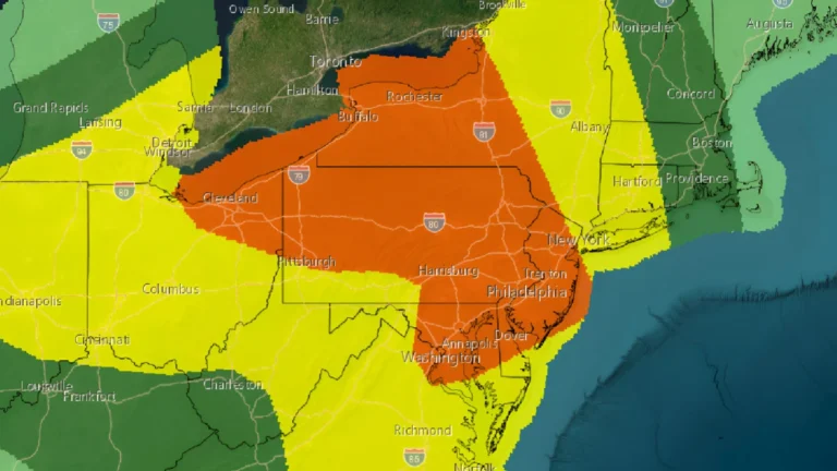
I am an Assistant Editor and Severe Weather & Science Journalist at The Watchers, specializing in real-time severe weather coverage, geophysical event reporting, and research-driven scientific analysis. You can reach me at rishav(at)watchers(.)news.

  • Flooding concerns grow in Montana as severe storms threaten parts of the Plains

    A storm system moving from the Great Basin into the Northern Rockies is expected to bring widespread rain, flooding concerns, and severe thunderstorms across multiple U.S. regions through June 1, 2026. The highest rainfall threat is forecast across portions of Montana on May 30, 2026, while severe storms capable of producing damaging winds and large hail are expected across parts of Nebraska and South Dakota.

  • Paris enters unprecedented May heat streak as France experiences record-breaking temperatures

    France recorded its hottest May day since records began on May 26, 2026, while temperatures climbed to 37.8 °C in southwestern parts of the country on May 28. Multiple stations across France set new all-time May temperature records this week as a prolonged heat dome pushed daytime temperatures into the upper 30s°C (upper 90s°F) and kept nighttime temperatures unusually high across much of the country.

  • Heavy rainfall and flash flooding forecast across Texas, the Gulf Coast, and the Appalachians

    A Slight Risk area for excessive rainfall remains in effect across southeast Texas, the central Gulf Coast, and parts of the Ohio Valley into the central Appalachians where slow-moving thunderstorms may produce flash flooding over saturated ground through May 27. Deep Gulf moisture and a slow-moving weather pattern are forecast to fuel multiple rounds of heavy rain from southeast Texas to the central Appalachians, increasing the risk of flash flooding in vulnerable areas through late week