
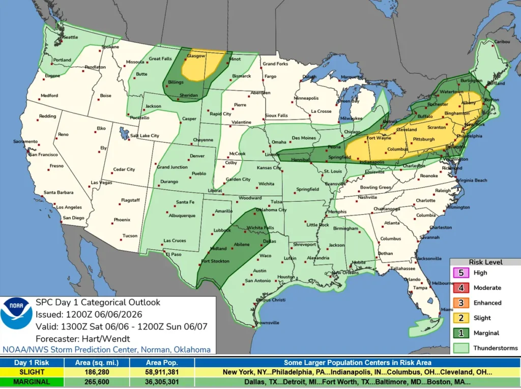
SPC upgrades severe thunderstorm risk to Enhanced for Mid-Atlantic and Northern High Plains
The Storm Prediction Center upgraded parts of the Mid-Atlantic and northern High Plains to an Enhanced Risk for severe thunderstorms on June 6, 2026, as severe storms and heavy rainfall continued across parts of the Plains, Mississippi Valley, Ohio Valley, and Northeast through June 8.
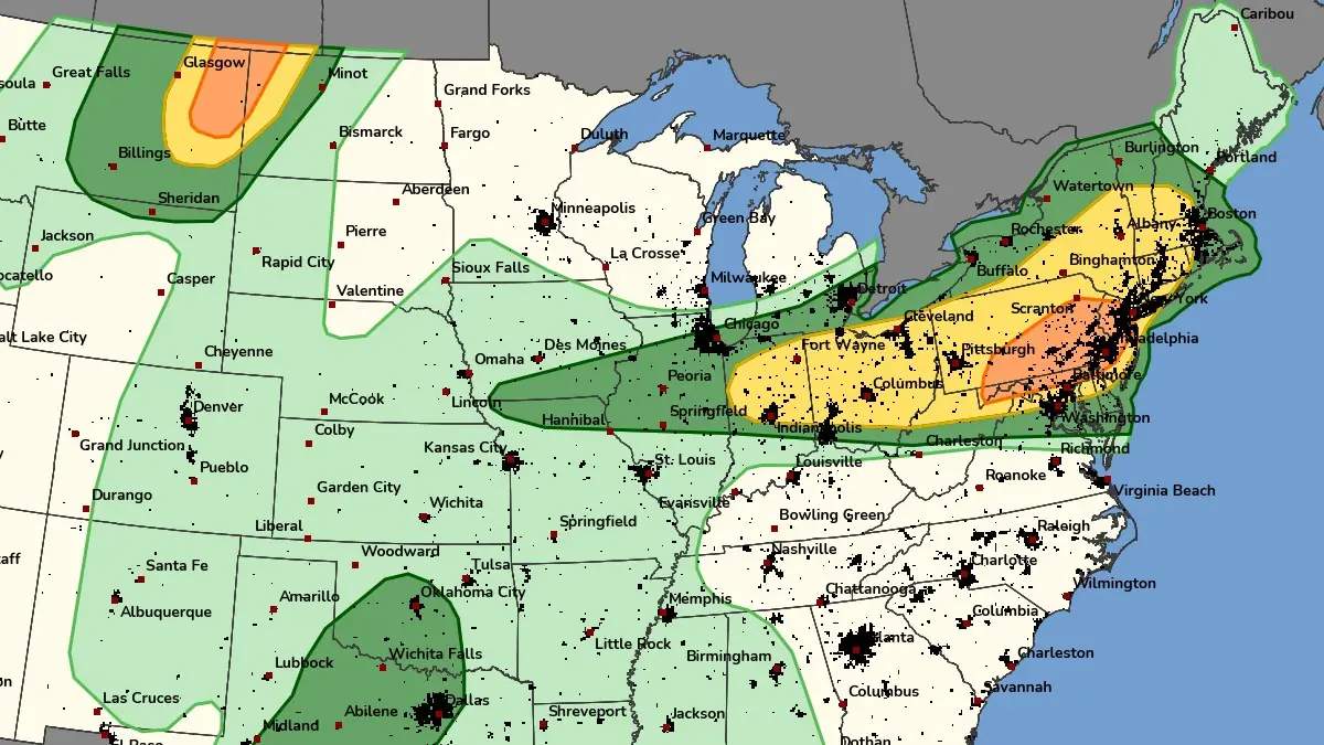
SPC Day 1 Convective Outlook on June 6, 2026. Credit: SPC
The National Weather Service Weather Prediction Center (WPC) and Storm Prediction Center (SPC) forecast severe thunderstorms and heavy rainfall across parts of the United States between 12:00 UTC on June 6 and 12:00 UTC on June 8.
WPC Slight Risk (Level 2/4) areas for excessive rainfall cover portions of the Southern Plains, Central Plains, Middle Mississippi Valley, and Lower Mississippi Valley, while SPC Slight Risk (Level 2/5) areas for severe thunderstorms extend across parts of the Central Plains, Upper and Middle Mississippi Valley, Northern High Plains, Ohio Valley, and Northeast.
Upper-level energy interacting with moisture flowing northward from the Gulf of Mexico supports widespread shower and thunderstorm development from the Southern Rockies and Southern Plains into the Lower Mississippi Valley. The heaviest rainfall on Saturday is forecast across portions of the Southern Plains, where localized flash flooding remains possible in urban areas, on roads, in small streams, and in low-lying locations.
A frontal boundary extending from the Upper Great Lakes southwestward into the Central Plains is forecast to move eastward toward the Northeast through Sunday morning. Thunderstorms developing along and ahead of the boundary on Saturday may produce damaging wind gusts, large hail, frequent lightning, and tornadoes across parts of the Central Plains and the Upper and Middle Mississippi Valley.
Heavy rainfall is also forecast across portions of the Middle Mississippi Valley and Central Plains through Sunday morning. According to WPC guidance cited in the forecast discussion, localized flash flooding remains the primary concern across vulnerable areas.
On Sunday, the front is forecast to reach the Ohio Valley and Northeast, where additional severe thunderstorms may develop. SPC has issued a Slight Risk (Level 2/5) for severe thunderstorms across parts of both regions through Monday morning, with forecast hazards including damaging winds, hail, frequent lightning, and tornado potential.
Farther south, renewed thunderstorm development is forecast across portions of the Southern Plains and Lower Mississippi Valley on Sunday. WPC has outlined a Slight Risk (Level 2/4) for excessive rainfall across parts of the region, where heavy rainfall may produce localized flooding in urban areas, roads, small streams, and low-lying locations.
The Northern High Plains face a separate severe-weather threat on Sunday as another frontal system moves eastward from the Northern Rockies. SPC has issued a Slight Risk (Level 2/5) for severe thunderstorms across parts of the region through Monday morning. Thunderstorms developing across the Northern High Plains may produce severe wind gusts, hail, and tornadoes.
Additional showers and thunderstorms are forecast across parts of the Central and Southern Plains and the Middle and Lower Mississippi Valley on Sunday, supporting another period of excessive rainfall and localized flash-flood potential through Monday morning. WPC has issued a Slight Risk (Level 2/4) for excessive rainfall across portions of these regions.
Elsewhere, onshore flow is expected to maintain periods of rain across parts of the Pacific Northwest through Sunday morning.
Update
20:07 UTC, June 6
SPC upgraded parts of the Mid-Atlantic and northern High Plains to an Enhanced Risk (Level 3/5) for severe thunderstorms on June 6, 2026. The main threat is damaging wind swaths, with some gusts possibly exceeding 121 km/h (75 mph), along with isolated large hail.
The upgrade follows the rapid eastward movement of a bow echo mesoscale convective system across the Mid-Atlantic and continued severe-storm development potential across the northern High Plains.
A broader Slight Risk remains in effect from the Ohio Valley into the Northeast, while excessive rainfall and localized flash-flood potential continue across parts of the Plains and Mississippi Valley.

References:
1 Short Range Public Discussion – WPC – June 6, 2026

I’m a science journalist and researcher at The Watchers, contributing to the Epicenter edition, where I cover peer-reviewed scientific research and emerging discoveries across Earth and space sciences. With a background in astronomy and a passion for environmental science, I’ve worked in shark and coral conservation in Fiji, conducting reef and shark-behavior research, contributing to mangrove restoration, and earning PADI Open Water and Coral Reef Certifications. I bring a blend of scientific rigor and storytelling to illuminate the discoveries shaping our planet and beyond.
El Niño punishment from God Pope Leo XIV non-Muslims to convert to Islam and Muslims to apply the Quran 100% to avoid death by floods lightnings hailstorm tornadoes sandstorm heatwave wildfires strong earthquakes more mag 7 earthquake tsunami volcano meteorites Hantavirus Ebola and viruses in US in Europe in Africa in Asia in Pacific Ocean in North and South America June 7, 2026.