
Southern High Plains under Extremely Critical fire weather outlook
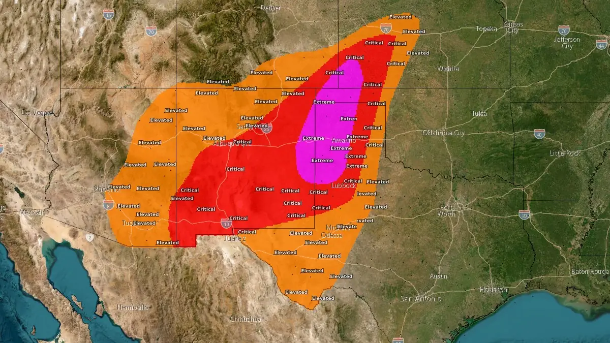
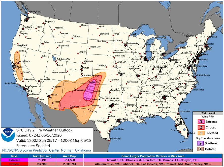
The Storm Prediction Center (SPC) placed 80 780 km² (31 190 mi²) of the southern High Plains under an Extremely Critical fire-weather outlook for Sunday, May 17, 2026, warning that dangerous wildfire spread conditions are expected across extreme eastern New Mexico, the Texas and Oklahoma Panhandles, extreme southeastern Colorado, and far southwestern Kansas.
SPC Critical Fire Weather valid 24 hours to 14:00 EDT on May 18, 2026. Credit: NWS/SPC
Over 511 000 people are inside the Extremely Critical area, including Amarillo, Texas, and Clovis, New Mexico on May 17. A broader Critical fire weather area covers 292 630 km² (112 985 mi²), with 2 305 781 people inside the risk area, including Albuquerque, Lubbock, Las Cruces, Roswell, and South Valley.
SPC forecast widespread sustained westerly surface winds of 40–50 km/h (25–30 mph) with relative humidity of 5–15% from the Desert Southwest into the southern High Plains. The agency said a pronounced mid-level impulse embedded in a broader upper trough over the Intermountain West will cross the Rockies on Sunday while a surface low deepens over the Plains.
Extremely Critical conditions are forecast where the wind and humidity overlap will coincide with critically dry fuel beds and several wildfire holdovers from recent ignitions.
Widespread sustained winds above the traditional Extremely Critical threshold of 50 km/h (30 mph) were “somewhat in question,” but grass fuel loading above the 95th percentile and holdover fires from the previous several days are compensating factors.
The extremely critical area may need to expand eastward across the remainder of the Texas and Oklahoma Panhandles and southwestern Kansas once forecasters gain higher confidence in the dryline position.
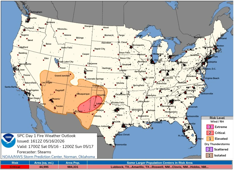
The Sunday outlook follows a Day 1 Critical fire weather area across much of southeastern New Mexico and parts of the Texas Panhandle, with 116 540 km² (44 995 mi²) and 984 331 people inside the Critical area.
Southwest winds were already increasing west of the dryline on May 16, with sustained speeds near 15–25 km/h (10–15 mph) and relative humidity near 10–25% under mostly sunny skies.
National Weather Service (NWS) office in Amarillo issued a Red Flag Warning for the Oklahoma and Texas Panhandles from 12:00 to 21:00 CDT Sunday, May 17. The office forecast southwest winds of 30–55 km/h (20–35 mph), gusts up to 70 km/h (45 mph), relative humidity as low as 4%, fuels at the 90th percentile or higher, Critical weather, and a fire environment rating of 9 out of 10.
NWS Albuquerque maintains Red Flag Warnings for portions of central and eastern New Mexico on May 16 and for southwestern, central, and eastern New Mexico from 10:00 to 21:00 MDT Sunday.
For several central and eastern zones, including the Northeast Plains, Middle Rio Grande Valley, Northeast Highlands, Sandia and Manzano Mountains, Central Highlands, and East Central Plains, the office forecast southwest winds of 30–50 km/h (20–30 mph), gusts up to 70 km/h (45 mph), and relative humidity of 6–15%.
Red Flag Warnings also cover parts of southwestern Kansas and West Texas. NWS Dodge City issued warnings for southwestern Kansas from 13:00 to 21:00 CDT Sunday, forecasting south to southwest winds of 40–55 km/h (25–35 mph), gusts up to 80 km/h (50 mph), and RH as low as 5%. NWS Lubbock issued a warning from 12:00 to 21:00 CDT Sunday for the Caprock and most of the Rolling Plains, with southwest winds of 30–40 km/h (20–25 mph), gusts up to 55 km/h (35 mph), RH as low as 5%, and critically dry fuels.
NWS Midland/Odessa issued a Red Flag Warning from 12:00 CDT / 11:00 MDT to 21:00 CDT / 20:00 MDT Sunday for southeastern New Mexico, the Guadalupe Mountains and surrounding foothills and plains, and the northwestern Permian Basin. The office forecast southwest winds of 30–50 km/h (20–30 mph), gusts up to 65 km/h (40 mph), RH as low as 5%, and an RFTI of 5 to 8, classified as critical to extreme.
NWS El Paso/Santa Teresa issued Red Flag Warnings for southwest and south-central New Mexico and parts of far west Texas from 12:00 Sunday to 00:00 MDT Monday. The office forecast southwest winds of 30–50 km/h (20–30 mph), gusts up to 80 km/h (50 mph), RH as low as 5%, no lightning, and an experimental RFTI of 4 to 5.
A separate warning for the Sacramento and Capitan Mountains runs from 07:00 Sunday to 00:00 MDT Monday, where NWS said Red Flag conditions may last through the night in favored downslope wind areas, calling it a rare situation.
NWS Pueblo issued Red Flag Warnings for parts of southern and eastern Colorado from 10:00 to 21:00 MDT Sunday. The warnings cover several fire-weather zones, including parts of Pueblo, Huerfano, Otero, Bent, Las Animas, Baca, Kiowa, and Prowers counties, with southwest winds, gusts up to 65 km/h (40 mph), RH as low as 6–9%, and fire behavior capable of rapid and erratic spread.
The National Interagency Coordination Center (NICC) placed the National Preparedness at Level 2 at 07:30 MDT on May 16, with 105 initial attack fires, 17 new large incidents, 1 large fire contained, and 30 uncontained large fires nationally. Its active incident resource summary showed 55 active incidents covering 86 123 ha (212 814 acres), with 32 crews, 236 engines, 20 helicopters, and 2 306 total personnel assigned.
In the Southwest Area, NICC listed 3 new fires and 3 uncontained large fires. Seven Cabins, 21 km (13 miles) northwest of Capitan, New Mexico, covered 225 ha (557 acres), was 0% contained, and had active fire behavior with wind-driven runs and short-range spotting. Structures and communication infrastructure were threatened.
Six Mile, 19 km (12 miles) southeast of Magdalena, covered 138 ha (341 acres), was 84% contained, and also had structures threatened, while Hummingbird, 24 km (15 miles) east of Glenwood, covered 2 315 ha (5 720 acres) and was 76% contained.
In the Southern Area, NICC listed 45 new fires, 12 new large incidents, and 15 uncontained large fires. Hunggate, 1.6 km (1 mile) south of Canyon, Texas, covered 7 001 ha (17 300 acres), was 45% contained, and had active fire behavior with wind-driven runs and flanking. Residences were threatened, and evacuations, area closures, and road closures were in effect.
Other Texas and Oklahoma fires in NICC list included Cherokee at 809 ha (2 000 acres), Western at 405 ha (1 000 acres), Ox Bow at 809 ha (2 000 acres), Wolf Canyon OK at 1 214 ha (3 000 acres), Shifty at 2 023 ha (5 000 acres), and Ballard at 676 ha (1 670 acres).
In Kansas, NICC reported Meade Lake in Meade County at 14 366 ha (35 500 acres), 0% contained, with numerous structures and energy infrastructure threatened. County Road 16 in Clark County covered 4 654 ha (11 500 acres), was 0% contained, and also had structures threatened.
Additionally, parts of California’s Central Valley region are under an Elevated fire weather area for Sunday. The agency forecast afternoon north-northwesterly surface winds of 30–40 km/h (20–25 mph) overlapping 15–20% RH amid drying fuels as a northwesterly mid-level speed maximum moves over California above a dry, mixed boundary layer.
References:
1 Day 1 Fire Weather Outlook – NWS/SPC – May 16, 2026
2 Day 2 Fire Weather Outlook – NWS/SPC – May 16, 2026
3 Red Flag Warnings – NOAA/NWS – May 16, 2026
4 Incident Management Situation Report – NIFC – May 16, 2026
I'm a dedicated researcher, journalist, and editor at The Watchers. With over 20 years of experience in the media industry, I specialize in hard science news, focusing on extreme weather, seismic and volcanic activity, space weather, and astronomy, including near-Earth objects and planetary defense strategies. You can reach me at teo /at/ watchers.news.
Commenting rules and guidelines
We value the thoughts and opinions of our readers and welcome healthy discussions on our website. In order to maintain a respectful and positive community, we ask that all commenters follow these rules.