
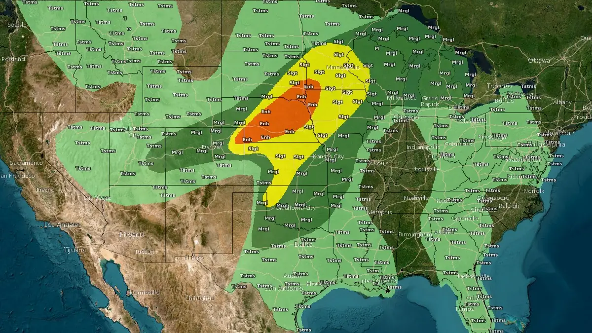
SPC forecasts two-day severe storm threat from Central Plains to Upper Midwest
The Storm Prediction Center (SPC) placed parts of the Central Plains under an Enhanced Risk of severe thunderstorms on Saturday, May 16, 2026, and parts of the Central Plains and Upper Midwest under Enhanced Risk on Sunday, with large to very large hail, damaging winds, and tornadoes forecast across the two-day period.
SPC Convective Outlook valid 24 hours to 14:00 EDT on May 18, 2026. Credit: NOAA/SPC
For Saturday afternoon and evening, severe storms capable of producing large to very large hail, severe or damaging winds, including some gusts over 121 km/h (75 mph), and a few tornadoes are expected across parts of the Central Plains into Iowa.
The Enhanced Risk covers parts of the Central High Plains and Central Plains, while a separate Slight Risk extends across parts of the Ohio Valley.
The Saturday setup centers on a surface low over southwest Kansas, a warm front extending through far southeast Nebraska toward southern Wisconsin, and a developing low farther west over southeast Colorado.
SPC expects persistent low-level moisture advection across the Central Plains as a deeper upper trough moves across the Intermountain West, with thunderstorm development favored late Saturday afternoon and early evening across northeast Colorado.
Initial storms over northeast Colorado are forecast to become supercellular, with large to very large hail as the primary hazard. SPC said the early activity should be high-based, with strong downdrafts supporting a quick transition toward a linear mode, although a tornado risk remains with southern supercells that persist into the early evening as the low-level jet strengthens.
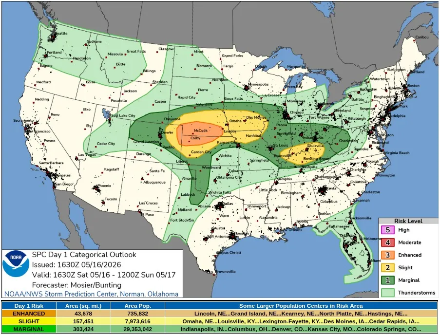
An intense bowing cluster is forecast to develop Saturday evening near the southern Nebraska and northern Kansas border region, then move eastward along or near the warm front. Significant wind gusts over 120 km/h (75 mph) are possible with this line, and expanded the Enhanced Risk eastward to account for a higher probability of strong gusts into more of southeast Nebraska.
Farther east on Saturday, SPC expects additional severe thunderstorm development along or near the warm front from far southeast Nebraska across southern Iowa, with some uncertainty over whether the boundary consolidates farther south into far northern Missouri.
Environmental conditions support supercells with all severe hazards, including isolated hail 5 cm (2 inches) or larger and tornadoes, although storm interference and a messy convective mode may limit storm discreteness.
Across the Mid-Mississippi Valley into the Midwest and Ohio Valley, Saturday’s severe potential was tied to mesoscale features, including a mesoscale convective vortex moving through southeast Missouri toward the Ohio River vicinity. Effective bulk shear of 55 to 75 km/h (30 to 40 kt) is expected to support organized updrafts, with isolated hail early and a transition toward damaging gusts as storms become more linear.
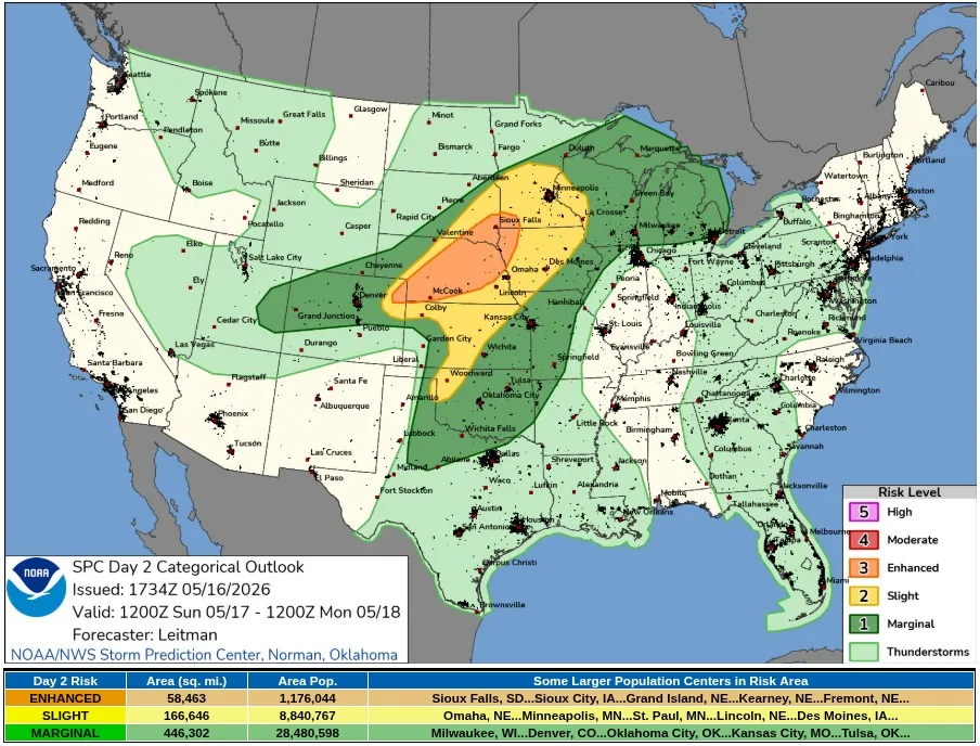
The severe-weather focus shifts north and east on Sunday, with far northeast Colorado, portions of Nebraska, southeast South Dakota, far southwest Minnesota, and northwest Iowa under an Enhanced Risk.
Severe storms are expected Sunday afternoon into Sunday night from parts of the Central Plains into the Upper Midwest, along with supercells capable of very large hail and strong tornadoes, before one or more linear bands increase the wind-damage risk.
Sunday’s outlook is supported by a strong upper trough digging across the western United States and pivoting east toward the Rockies and Four Corners region into early Monday. SPC expects enhanced southwesterly deep-layer flow from the Central High Plains to the Upper Midwest, while dew points of about 18 to 20°C (64-68°F) spread north from the southern and central Plains into the Mid-Missouri and Mississippi valleys and as far north as southern Minnesota and Wisconsin.
At the surface on Sunday, a lee low deepening is forecast across southeast Colorado into western Kansas, with a sharp dryline extending south across west-central Kansas into far western Oklahoma and adjacent Texas. A cold front is expected from eastern South Dakota and central Nebraska into northeast Colorado by afternoon, while a warm front extends west to east across southern Minnesota and Wisconsin into Lower Michigan.
The strongest Sunday tornado and hail signal is forecast across parts of eastern Nebraska, southeast South Dakota, southwest Minnesota, and northwest Iowa.
SPC expects a narrow corridor of strong destabilization, with mixed-layer CAPE of 2 500 to 3 500 J/kg and effective shear greater than 75 km/h (40 kt), supporting supercell wind profiles, increasing low-level storm-relative helicity, and curved low-level hodographs.
A few supercells in that corridor may produce strong tornadoes and large to very large hail, especially across northeast Nebraska, far southeast South Dakota, southwest Minnesota, and northwest Iowa. The severe risk is expected to transition later Sunday into one or more linear or bowing segments near the east- to southeast-moving cold front as the low-level jet strengthens during the evening.
A more conditional Sunday risk extends across Kansas into the southern Plains, where capping and weak large-scale ascent may inhibit storm development along the dryline. If storms form from west-central Kansas into western Oklahoma, the eastern Texas Panhandle, and western north Texas, large to very large hail and strong to severe wind gusts are possible in a favorable thermodynamic and kinematic environment.
References:
1 SPC Day 1 Convective Outlook – NWS/SPC – May 16, 2026
2 SPC Day 2 Convective Outlook – NWS/SPC – May 16, 2026
I'm a dedicated researcher, journalist, and editor at The Watchers. With over 20 years of experience in the media industry, I specialize in hard science news, focusing on extreme weather, seismic and volcanic activity, space weather, and astronomy, including near-Earth objects and planetary defense strategies. You can reach me at teo /at/ watchers.news.
Commenting rules and guidelines
We value the thoughts and opinions of our readers and welcome healthy discussions on our website. In order to maintain a respectful and positive community, we ask that all commenters follow these rules.