
Lewotobi Laki-laki volcano alert raised to highest level, Indonesia
Indonesia’s Geological Agency raised the alert status of Mount Lewotobi Laki-laki in East Flores to Level IV (Awas) at 10:00 WITA on September 6, 2025, due to increased seismicity, continuous tremor, and deformation indicating shallow magma ascent.

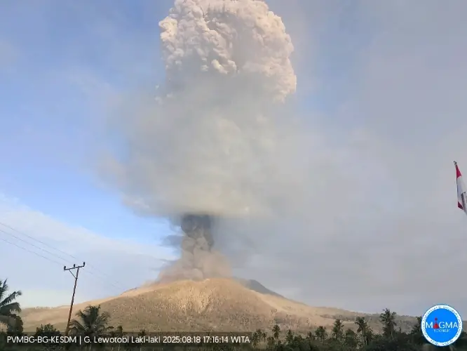
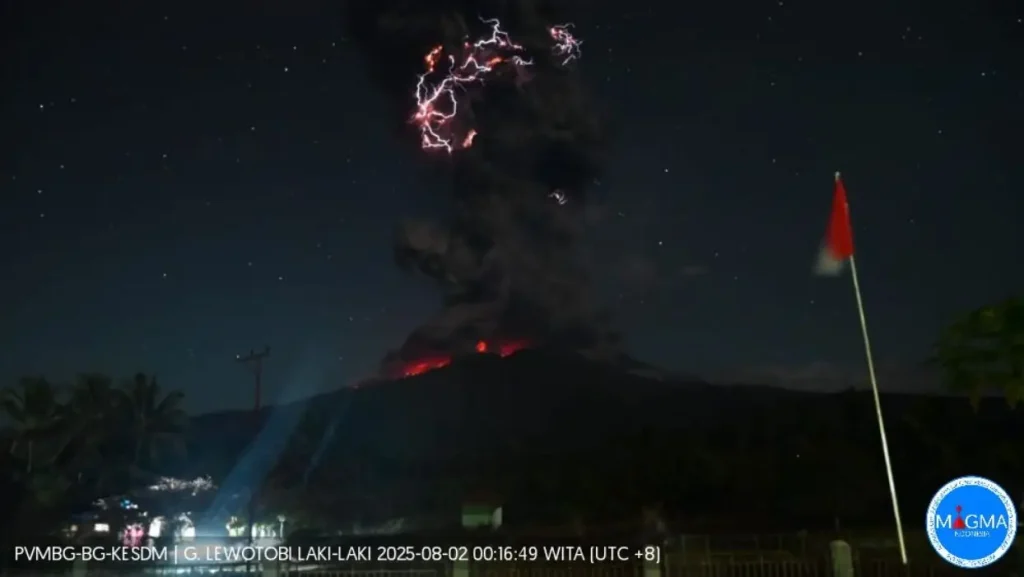
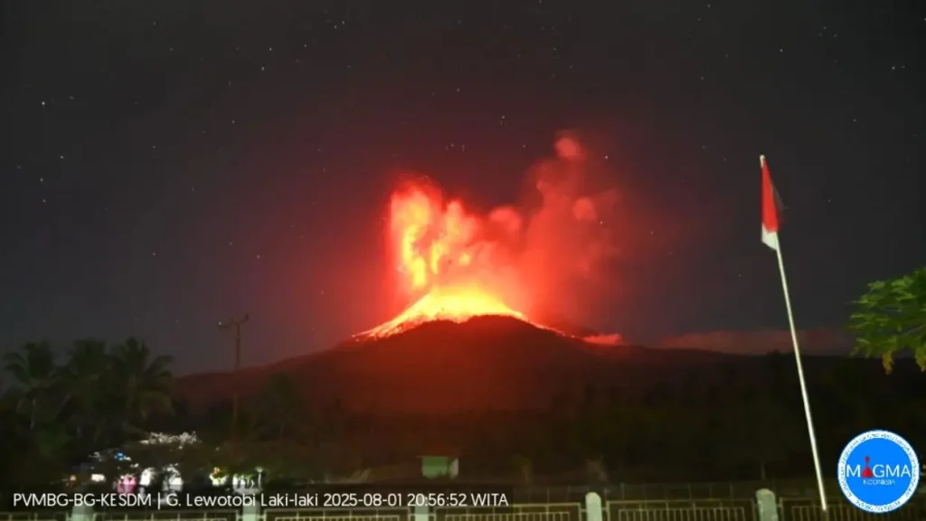
Photo of Mount Lewotobi Laki-laki at 17:03 WITA on August 25, 2025. Credit: PVMBG-BG-KE SDM
The decision to raise the alert level followed a sustained increase in volcanic activity recorded at Mount Lewotobi Laki-laki, including continuous tremor and a sharp rise in deep and shallow volcanic earthquakes.
Between August 30 and September 4, instruments at the volcano registered over 240 seismic events, including harmonic and non-harmonic tremors, low-frequency events, and deep volcanic quakes.
On September 6, seismic readings showed uninterrupted tremor, interpreted as magma migration from deeper zones toward the surface.
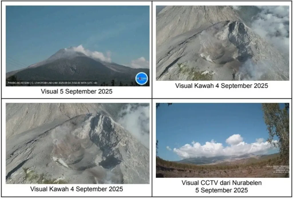
Simultaneously, visual observations indicated continuous white emissions rising between 50 and 1 000 meters (164–3 280 feet) above the summit.
Air temperatures around the volcano ranged from 17.1°C to 40°C (62.8°F to 104°F), with winds blowing toward all quadrants.
No eruption was observed in the preceding days, suggesting a possible obstruction within the conduit, increasing the likelihood of internal pressurization and sudden explosive activity typical of open-system volcanoes.
Tiltmeter data from the volcano’s upper flanks recorded gradual inflation over the past week, indicating volumetric increase within the edifice due to magma intrusion.
This inflation was most prominent at shallow depths, suggesting imminent eruptive potential. In contrast, data from the Global Navigation Satellite System (GNSS) network indicated a deflation trend, likely reflecting gas release or shallow degassing episodes. The combined deformation signals point to active processes within the upper conduit, consistent with increased risk of sudden eruption.
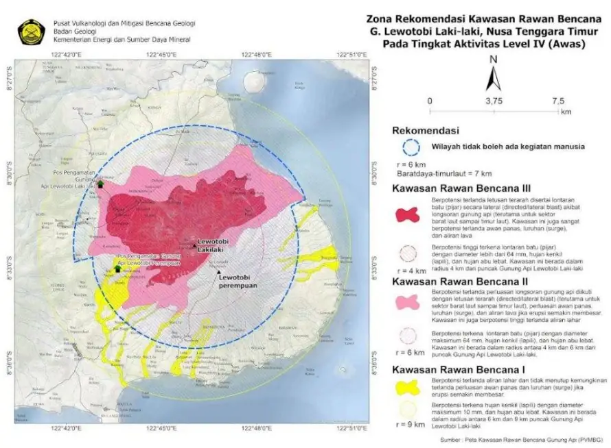
In response to the elevated threat level, the Geological Agency has enforced a 6 km (3.7 miles) exclusion radius around the summit, with an extended 7 km (4.3 miles) sectoral exclusion zone from the southwest to the northeast.
These sectors correspond to the dominant vent alignment and probable pyroclastic flow paths.
Residents, climbers, and all forms of public activity are strictly prohibited within these areas until further notice.
The open-system nature of Mount Lewotobi Laki-laki allows for vertical magma ascent with minimal resistance, increasing the risk of sudden, high-energy eruptions without significant precursor signals.
In the event of intense rainfall, there is a high probability of lahars along drainage basins that originate from the volcano. These include the rivers of Nawakote, Dulipali, Nobo, Hokeng Jaya, and Nurabelen. Lahar flows may occur rapidly and transport volcanic debris at high velocity, posing direct threats to downstream communities.
Ash emissions from future eruptive phases may also cause disruptions to aviation, particularly if dispersal is directed toward local airports or regional flight routes. Residents affected by ashfall are advised to wear respiratory protection such as masks to reduce health impacts.
The Geological Agency has instructed local governments and emergency management officials to maintain continuous coordination with the Mount Lewotobi Laki-laki Volcano Observation Post in Pululera Village, and with the Center for Volcanology and Geological Hazard Mitigation (PVMBG).
Public access to real-time updates and advisories is available via the Magma Indonesia platform and official channels operated by the Geological Agency.
Mount Lewotobi Laki-laki’s current increase to Level IV follows months of sustained activity, marked by frequent ash emissions, seismic swarms, and multiple eruptive phases.
On August 18, dense gray ash plumes rose to heights of 8 km (26 200 feet) above the summit between 00:38 and 02:21 local time, with additional plumes reaching 3.5–4 km (11 500–13 100 feet) later in the day.
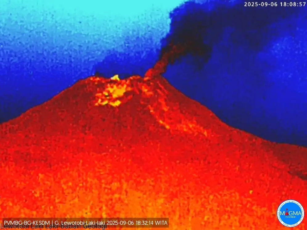
Incandescent ejecta was visible on the upper flanks during night hours, and ash emissions were observed along both the summit and lower slopes. Subsequent activity continued throughout August, with PVMBG reporting gray ash columns up to 2 km (6 560 feet) above the crater during the period of August 24–25.
Two eruptive events occurred at 20:24 LT on August 25 and 03:11 LT on August 26, though visual confirmation was not possible due to weather conditions.
Despite this, by August 23 at 18:00 LT, PVMBG downgraded the volcano’s status from Level IV (Awas) to Level III (Siaga), citing decreased seismicity and more stable deformation signals. However, low-frequency tremors and ongoing inflation indicated a continued magma recharge at depth.
White and ash-laden emissions persisted during this lowered alert phase, with plume heights of 500–1 600 m (1 640–5 250 feet) observed daily.
Earlier, on August 16, alert level had been raised to Level IV after seismic monitoring detected increased non-harmonic tremor signals and inflation trends, coinciding with the aftermath of a minor eruption on August 9.
Ash emissions between August 13–17 included plumes up to 1 km (3 280 feet) in altitude and occasional crater incandescence. On August 13 at 14:05 and 17:47 LT, ash plumes rose 200 m (660 feet) above the summit and drifted west and southwest.
Local air traffic was intermittently disrupted throughout August, with ashfall prompting the cancellation of several flights in and out of Maumere (61 km / 38 miles west), Ende (125 km / 78 miles west-southwest), and Bajawa (200 km / 124 miles west).
The Lewotobi volcanic complex is located in eastern Flores Island and consists of two closely aligned stratovolcanoes — Lewotobi Laki-laki and Lewotobi Perempuan, commonly referred to as the “husband and wife” pair.
Their summit craters lie less than 2 km (1.2 miles) apart along a northwest–southeast axis.
The conical Laki-laki, situated to the northwest, has shown more frequent eruptive behavior during the 19th and 20th centuries. In contrast, the broader and taller Perempuan produced confirmed eruptions in 1921 and 1935.
Both summit craters are breached to the north and have hosted the growth of small lava domes over the past century. A secondary cone, Iliwokar, is positioned on the eastern flank of Perempuan, adding to the morphological complexity of the edifice.
References:
1 Aktivitas G. Lewotobi Laki-laki Meningkat, Badan Geologi Naikkan Tingkat Aktivitas Jadi Awas – Ministry of Energy and Mineral Resources (ESDM), Indonesia – ESDM – September 6, 2025;
2 Special Report No. 89/GL.03/BGL/2025 – Geological Agency, Ministry of Energy and Mineral Resources – Document issued September 6, 2025
3 Weekly Volcanic Activity Reports – Global Volcanism Program, Smithsonian Institution – GVP – August–September 2025;
4 Lewotobi geologic summary – GVP – Accessed September 7, 2025.
I'm a dedicated researcher, journalist, and editor at The Watchers. With over 20 years of experience in the media industry, I specialize in hard science news, focusing on extreme weather, seismic and volcanic activity, space weather, and astronomy, including near-Earth objects and planetary defense strategies. You can reach me at teo /at/ watchers.news.
Commenting rules and guidelines
We value the thoughts and opinions of our readers and welcome healthy discussions on our website. In order to maintain a respectful and positive community, we ask that all commenters follow these rules.