
Tropical Storm Peipah hits Japan, evacuation orders issued for 660 000
Tropical Storm Peipah made landfall in Kochi Prefecture, Japan, around 01:00 JST on Friday, September 5, 2025, bringing strong winds and heavy rainfall across multiple regions. The storm injured at least 24 people and damaged or destroyed several homes. Authorities issued evacuation orders for more than 600 000 residents.
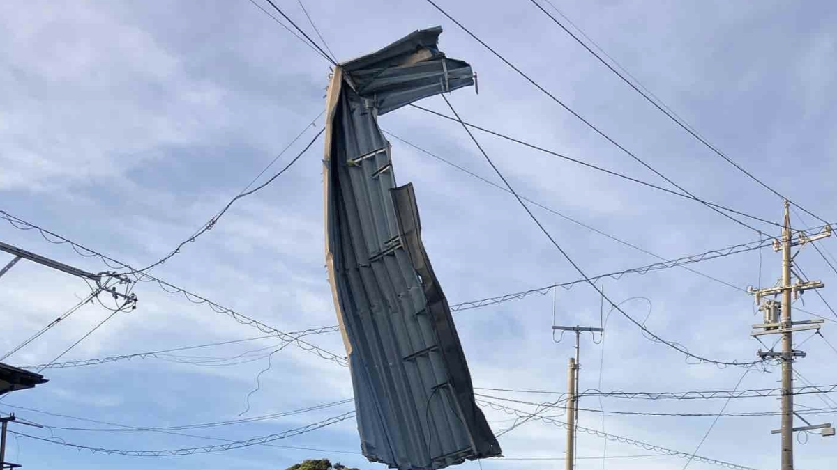
Part of a roof hanging from and elctrical wire in Shizuoka Prefecture after getting blown off due to stromg winds from Tropical Storm Peripah. Credit: Chubu Power Grid
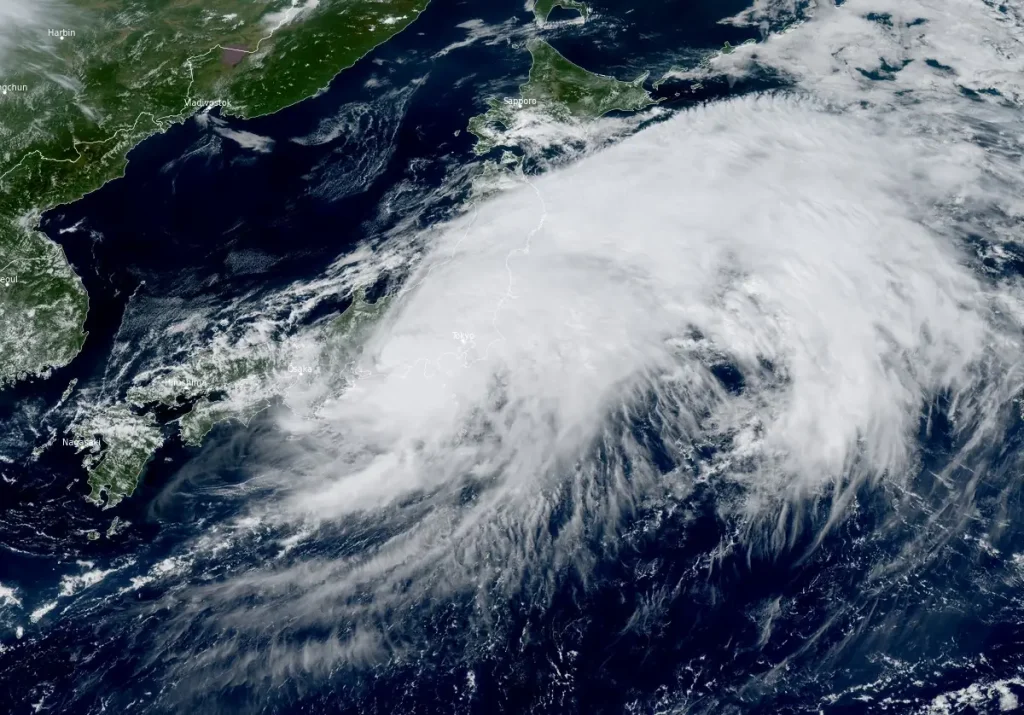
Tropical Storm Peipah made landfall near Sukumo City in Kochi Prefecture at around 01:00 LT on Friday, September 5 (16:00 UTC on September 4). Over 600 000 people were under evacuation orders as the storm brought heavy rains, flooding and the threat of landslides.
The storm is now moving eastward along the Pacific coast and is forecast to continue bringing heavy rainfall across wide areas of the country.
Strong gusts from the storm have caused widespread damage and injuries in, Makinohara City, Kakegawa City, Yaizu City, and Yoshida Town. A total of 24 injuries have been reported in these places as the strong winds left 40 houses damaged or destroyed.
The agency warned of the potential for landslides, flooding in low-lying areas, and river overflows. It also advised caution against lightning, high waves, strong gusts, and possible tornadoes.
Authorities issued evacuation orders for more than 660 000 people, including thousands in Chiba Prefecture east of Tokyo, where swollen rivers and saturated soil raised concerns about flash floods and landslides.
As of 20:00 LT on Friday, 13 690 customers across the Shizuoka prefecture remain without power after winds from the typhoon downed power lines across the region.
Rail operators reported partial suspensions and delays, including on the Tōkaidō Shinkansen, after rainfall exceeded safety thresholds. Road traffic was disrupted in central and eastern Japan. Domestic flight operations, especially to islands south of Kyushu, experienced delays and cancellations.
According to the Japan Meteorological Agency (JMA), heavy rainfall has been reported across the affected affected region. Shimokitayama Village in Nara Prefecture recorded 80 mm (3.1 inches) in one hour through 03:00 LT on Friday. Meanwhile, Kumano City in Mie Prefecture, recorded 63 mm (2.5 inches) during the same period.
According to NHK, linear rainbands developed in Miyazaki Prefecture on Thursday night, with Tsuno Town receiving 465.5 mm (18.3 inches) in 24 hours through 21:00 LT — the highest on record at that observation site.
Meanwhile, Jiji Press reported 373.5 mm (14.7 inches) in Tsuno for a 24-hour period through 17:00 LT.
The JMA has forecast up to 250–300 mm (9.8–11.8 inches) of rainfall through late Friday night in parts of Tokai and Shikoku, and up to 200–250 mm (7.9–9.8 inches) in Kinki and Kanto-Koshin. Rainfall totals may reach 150–200 mm (5.9–7.9 inches) in Tohoku.
Authorities have urged residents to remain alert to further warnings and to follow evacuation instructions, as heavy rainfall is expected to persist into the weekend across much of Japan.
According to Joint Typhoon Warning Center (JTWC) bulletin issued at 09:00 UTC today, Tropical Storm Peipah is forecast to track generally eastward through over the next 24 hours under the influence of both the subtropical ridge to the south and an eastward-propagating major shortwave trough.
The system has begun extratropical transition (ETT), evident from its increasing interaction with upper-level westerlies and rising vertical wind shear. The storm now exhibits hybrid characteristics of both tropical and extratropical cyclones.
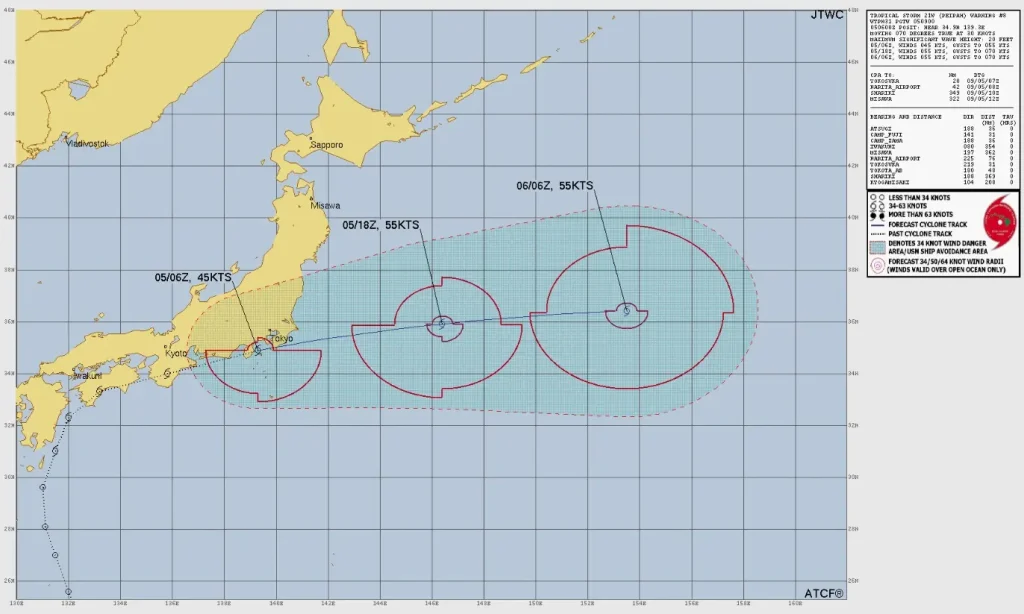
As the mid-latitude trough continues to deepen north of the system, enhanced thermal advection will promote baroclinic intensification, resulting in Peipah evolving into a storm-force extratropical cyclone.
The ETT process is expected to complete within 24 hours, with peak sustained winds potentially intensifying to around 102 km/h (63 mph) as the system accelerates away from Honshu’s eastern seaboard.
Numerical model guidance has tightened significantly over the past 6 to 12 hours. Cross-track spread at 09:00 UTC on September 6 has decreased to 280 km (170 miles), with notable reduction in along-track variability compared to previous model runs. Consequently, the JTWC track forecast aligns closely with the multi-model consensus, issued with high confidence.
Intensity guidance presents moderate spread, ranging from 93 to 120 km/h (58 to 75 mph) at 09:00 UTC on September 6. The HAFS-A model continues to show the most aggressive intensification scenario. Due to lingering uncertainty in the vortex structure during ETT, the JTWC intensity forecast is assessed with medium confidence.

I am an Assistant Editor and Severe Weather & Science Journalist at The Watchers, specializing in real-time severe weather coverage, geophysical event reporting, and research-driven scientific analysis. You can reach me at rishav(at)watchers(.)news.
Commenting rules and guidelines
We value the thoughts and opinions of our readers and welcome healthy discussions on our website. In order to maintain a respectful and positive community, we ask that all commenters follow these rules.