
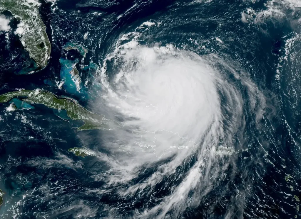
Category 4 Hurricane Erin located just east of southeast Bahamas, life-threatening surf expected along U.S. East Coast
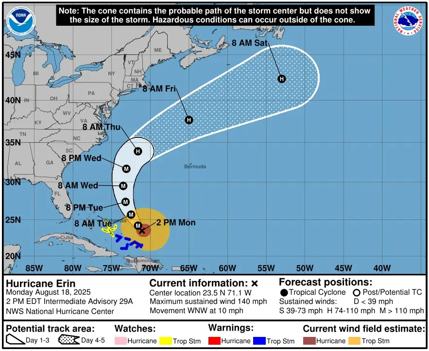
Category 4 Hurricane Erin was located 220 km (140 miles) north-northeast of Grand Turk Islands at 18:00 UTC (14:00 EDT) on August 18, 2025, with maximum sustained winds of 220 km/h (140 mph), maintaining Category 4 strength while moving northwest at 20 km/h (13 mph).
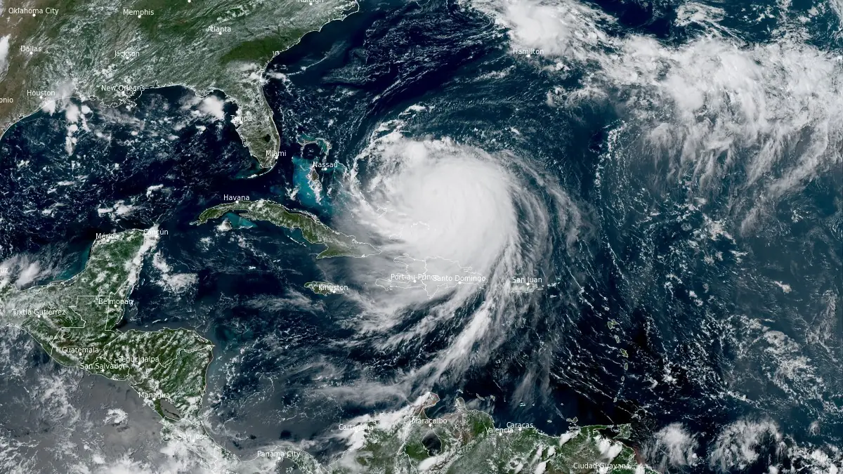
Satellite image of Hurricane Erin at 18:50 UTC on August 18, 2025. Credit: NOAA/GOES-East, RAMMB/CIRA, The Watchers
- Bands of heavy rainfall are expected through today over portions of Hispaniola and through Tuesday, August 19 for the Turks and Caicos and the Bahamas eastward from San Salvador Island. Flash and urban flooding are possible.
- Tropical storm conditions are expected in the Turks and Caicos Islands and in the southeast Bahamas today, August 18 while tropical storm conditions are possible in portions of the central Bahamas late today through Tuesday.
- Erin is expected to produce life-threatening surf and rip currents along the beaches of the Bahamas, much of the east coast of the U.S., Bermuda, and Atlantic Canada during the next several days.
- Tropical storm conditions and coastal flooding are possible in the North Carolina Outer Banks beginning late Wednesday, August 20 and a Tropical Storm and Storm Surge Watch may be required later today.
- Interests along the Outer Banks of North Carolina and Bermuda should monitor the progress of Erin.
Forecasts indicate Erin will turn north later on August 18 into August 19, passing east of the southeastern Bahamas and tracking between Bermuda and the U.S. East Coast during midweek. Erin is expected to remain a major hurricane during this period.
Hurricane-force winds extended outward up to 130 km (80 miles) from the center, while tropical-storm-force winds reached up to 370 km (230 miles). A Tropical Storm Warning was in effect for the Turks and Caicos Islands and the southeastern Bahamas. A Tropical Storm Watch was issued for the central Bahamas.
Outer bands of Erin are expected to bring localized heavy rainfall to parts of Hispaniola today, and to the Turks and Caicos and the Bahamas east of San Salvador Island through Tuesday. Forecast totals are 50 to 100 mm (2 to 4 inches), with isolated amounts up to 150 mm (6 inches).
The National Hurricane Center (NHC) warned of life-threatening surf and rip currents across the Bahamas, Bermuda, and the U.S. Eastern Seaboard throughout the week. Coastal flooding is possible in areas experiencing onshore winds, particularly in the Turks and Caicos Islands and the southeastern Bahamas.
In Puerto Rico, tropical-storm-force winds and heavy rainfall caused widespread power outages, affecting more than 147 000 customers. Authorities closed ports and cancelled flights in Puerto Rico and the U.S. Virgin Islands.
In North Carolina, states of emergency were declared for parts of the Outer Banks, including Hatteras Island. Local authorities ordered evacuations due to risks of flooding, coastal erosion, and infrastructure damage, with particular concern along Highway 12.

I’m a science journalist and researcher at The Watchers, contributing to the Epicenter edition, where I cover peer-reviewed scientific research and emerging discoveries across Earth and space sciences. With a background in astronomy and a passion for environmental science, I’ve worked in shark and coral conservation in Fiji, conducting reef and shark-behavior research, contributing to mangrove restoration, and earning PADI Open Water and Coral Reef Certifications. I bring a blend of scientific rigor and storytelling to illuminate the discoveries shaping our planet and beyond.
Commenting rules and guidelines
We value the thoughts and opinions of our readers and welcome healthy discussions on our website. In order to maintain a respectful and positive community, we ask that all commenters follow these rules.