
Steady eruption near Grindavík, Iceland
Eruptive activity near Grindavik, Iceland, remains steady on November 28, 2024, with the eruption continuing from a single vent and lava flowing east and southeast. Gas pollution caused by northeast winds at 35 – 55 km/h (20 – 35 mph) was moving toward Grindavík today and was forecast to spread to nearby areas as the weather patterns change.

The fissure opening around midnight taken from the Coast Guard helicopter. Lights in the town of Grindavík seen in the distance on November 28, 2024. Image credit: Civil Protection/Björn Oddsson
Eruptive activity near Grindavik has been steady over the last 24 hours, with lava now flowing predominantly east and southeast, towards and along the base of Fagradalsfjall, the Icelandic Met Office (IMO) reported at 15:50 UTC on November 28.
The lava field near Fagradalsfjall has expanded slightly but continues to thicken.
Volcanic tremor has remained stable alongside eruptive activity in the vent while the rate of subsidence around Svartsengi has significantly reduced.
However, because daily changes are minor, the trend of deformation measurements must be monitored over the next several days to determine whether the uplift has resumed.
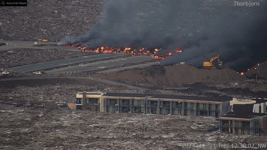
The eruption site has been limited to a single active vent of Stóra-Skógfell with lava flowing eastward. Flows beneath the solid crust have been found near the protective wells at Svartsengi and the Blue Lagoon geothermal spa.
The eruption tremors have stabilized and the ground subsidence around Svartsengi has slowed down on November 28.
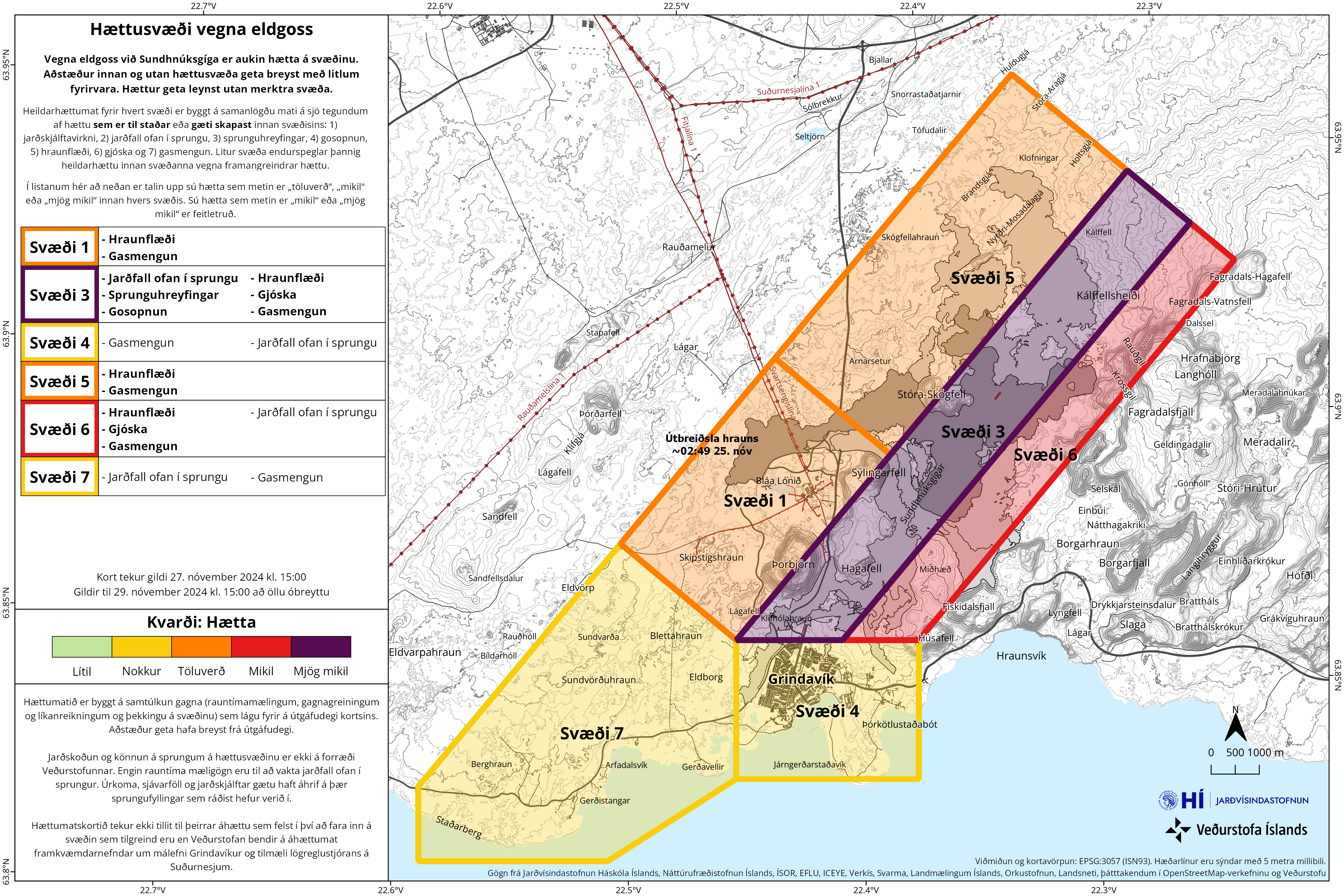
On November 27, IMO issued an updated hazard assessment, valid until 15:00 on November 29, assuming no significant changes. Based on the eruption’s development over the past few days and the gas dispersion forecast, the hazard assessment has been revised from the previous version.
The main changes involve Zone 1 (Svartsengi), where the overall hazard level is now assessed as considerable (amber) instead of high (red), and Zone 4 (Grindavík), where the overall hazard level has been downgraded from considerable (amber) to moderate (yellow).
In Zone 1 (Svartsengi), the risk of lava flow and gas pollution remains high, but the risk of tephra fall has been downgraded to moderate from considerable.
For Zone 4 (Grindavík), the only change is that the risk of gas pollution is now assessed as “considerable,” down from “very high.” According to the gas dispersion forecast, there is a likelihood of gas pollution in Grindavík on November 29.
The Reykjanes volcanic system, located along the Mid-Atlantic Ridge, is known for regular rifting and basaltic eruptions. Its volcanic history includes crater rows, shield volcanoes, and fissure vents. The current eruption follows the same pattern of activity seen in the 2023 – 2024 Sundhnúkur eruptions.
Reference:
1 Steady Activity from the Eruption Over the Last 24 Hours – IMO – November 28, 2024

Rishika holds a Master’s in International Studies from Stella Maris College, Chennai, India, where she earned a gold medal, and an MCA from the University of Mysore, Karnataka, India. Previously, she served as a Research Assistant at the National Institute of Advanced Studies, Indian Institute of Science, Bengaluru, India. During her tenure, she contributed as a Junior Writer for Europe Monitor on the Global Politics website and as an Assistant Editor for The World This Week. Her work has also been published in The Hindu newspaper, showing her expertise in global affairs. Rishika is also a recipient of the Women Empowerment Award at the district level in Haryana, India, in 2022.
Published in the last 24 hours
- In September 1859, a solar storm lit up the night sky so brightly that gold miners in the Rocky Mountains woke up after midnight and started cooking breakfast, convinced the aurora glowing over their camp was the sunrise Epicenter
- A patch of warm Pacific water that could become the strongest El Niño in more than 70 years sits thousands of miles from any American town, yet it is already the main reason NOAA expects a wetter winter across the South and a milder one across the North
- A 19-year-old Nebraska teacher reportedly tied her pupils together with twine and led them to safety through a blizzard in January 1888 Epicenter
