
Arctic cold blast sweeping across the northern Plains and Midwest, U.S.
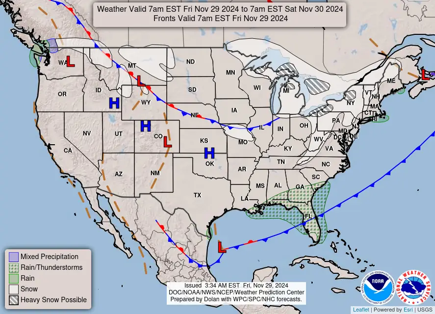
An Arctic cold front is descending from the northern Plains into the Midwest on Friday, November 29, 2024, bringing the coldest temperatures since mid-February and significant snowfall across the Great Lakes region.

Image credit: NOAA/NWS
An Arctic cold air outbreak is sweeping south and east from the northern Plains into the Midwest on Friday, November 29.
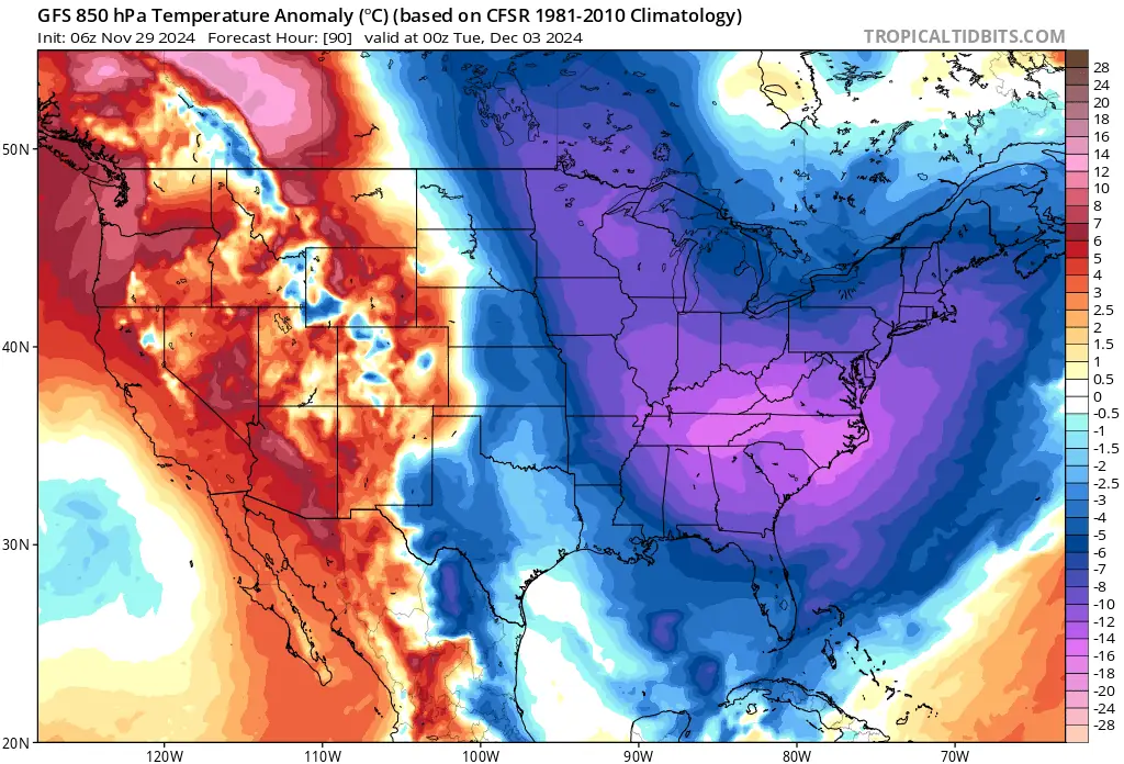
This Arctic blast is expected to persist into the following week, bringing the coldest temperatures since mid to late February, according to the NWS Weather Prediction Center (WPC).
Minimum wind chills between Friday and Saturday morning, the peak of outbreak, are predicted to drop below freezing across much of the Northern Plains and Upper Midwest.
In the Dakotas and Minnesota, wind chills are expected to plummet below -26 °C (-15 °F), with parts of North Dakota potentially reaching between -38 and -40 °C (-34 and -40 °F ).

Upper-level troughing over the Great Lakes into the Northeast, combined with cold air streaming across the region, will produce heavy lake-effect snow over Michigan’s Upper Peninsula through Sunday, December 3.
Lighter snowfall is expected over much of the west coast of Michigan’s Lower Peninsula, heavier lake-effect snow will develop in parts of the northern Lower Peninsula and areas downwind of Lakes Erie and Ontario through Sunday.
Prolonged lake-effect snow and snow showers have already developed east and southeast of the Great Lakes, creating deep and drifting snow in the hardest-hit regions. Travel disruptions are likely along major corridors, including I-90 between Cleveland and Buffalo and I-81 north of Syracuse.
Conditions in the hardest-hit regions are expected to range from difficult to impossible, with several feet of snow anticipated.
Lake Effect Snow Warning is in effect for Erie and Crawford Counties in Pennsylvania and Lake, Geauga, and Ashtabula Counties in Ohio through 10:00 LT on Saturday, November 30.
A Winter Weather Advisory is in effect in Cuyahoga County through 10:00 LT on Saturday.


“A multi-day lake effect snow event off Lake Erie is ongoing. Heavy lake effect snow bands this morning have already produced a total of 8 – 30 cm (3 – 12 inches) of new snow, with snowfall rates of 2.5 – 7.6 cm (1 – 3 inches) per hour and one-quarter mile (0.4 km) visibility, making travel very difficult across the region,” meteorologists at the NWS Cleveland office said early Friday (local time).
Snow bands will continue over the next 24 hours across the snowbelt with slight north and south shifts. Snowfall totals are expected to range from 25 – 71 cm (10 – 28 inches), with the highest amounts occurring where bands persist.
A break in lake effect snow is becoming increasingly likely on Saturday, November 30. However, another round of impactful, accumulating lake effect snow is expected to return for Sunday and Monday.

I am an Assistant Editor and Severe Weather & Science Journalist at The Watchers, specializing in real-time severe weather coverage, geophysical event reporting, and research-driven scientific analysis. You can reach me at rishav(at)watchers(.)news.
Commenting rules and guidelines
We value the thoughts and opinions of our readers and welcome healthy discussions on our website. In order to maintain a respectful and positive community, we ask that all commenters follow these rules.