
Typhoon “Yingxing” makes double landfall over Phillipines, 17 000 evacuated
Typhoon ‘Yinxing’ made dual landfalls in the Philippines’ Cagayan region on Thursday, November 7, 2024, forcing the evacuation of thousands of people and delivering high-impact winds, storm surges, and torrential rainfall to the area.
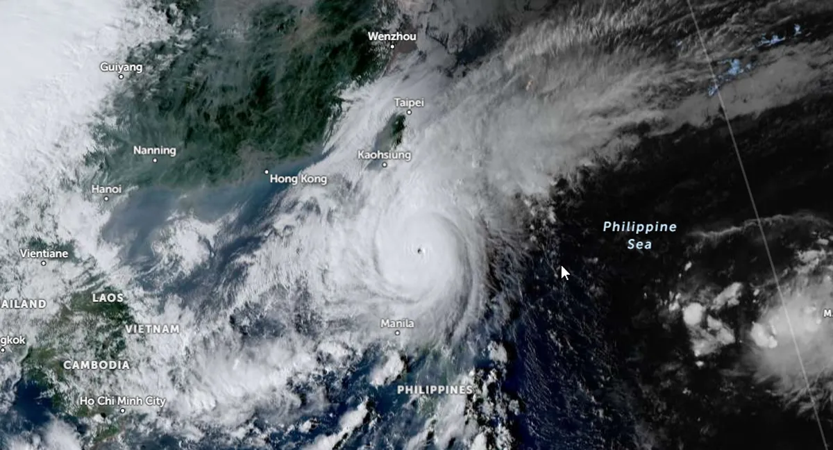
Satellite image of Typhoon "Yinxing" (Marce) at the time of first landfall over Santa Ana at 08:00 UTC on November 7, 2024. Image credit: JMA/Himawari-9, Zoom Earth, The Watchers
- Regardless of the position of the center of the eye in the next few hours, it must be emphasized that potentially life-threatening conditions due to typhoon-force winds, storm surge inundation, and torrential rainfall will be experienced in the Babuyan Islands and the northern portions of mainland Cagayan, Ilocos Norte, and Apayao, PAGASA warned at 18:00 UTC today (02:00 LT, November 8).
- The typhoon is forecast to continue to weaken for the next few days after it emerges over the coastal waters of the Ilocos Region due to the possible dry air intrusion from the prevailing northeasterly wind flow. Nevertheless, it will remain a typhoon throughout its passage within the Philippine Area of Responsibility (PAR) region.
Typhoon “Yinxing” — known as Marce in the Philippines, made landfall over Santa Ana in the country’s Cagayan region at approximately 08:00 UTC (16:00 local time) on Thursday, with maximum sustained winds of 175 km/h (109 mph) and gusts reaching up to 240 km/h (149 mph). The system’s central pressure was approximately 940 hPa at landfall.
Six hours after making landfall in Santa Ana, the typhoon made a second landfall over Sanchez-Mira in Cagayan at around 22:00 LT on Thursday. Maximum wind speeds near the center reached around 175 km/h (109 mph), with gusts of up to 290 km/h (180 mph). The system’s minimum central pressure at the time of this second landfall remained at approximately 940 hPa.
As of 02:00 LT on Friday, November 8, the system was located over Pasuquin, Ilocos Norte, with maximum sustained winds of 165 km/h (102 mph) and gusts of up to 275 km/h (171 mph). The system’s minimum central pressure was 945 hPa, and it was moving in a west-southwest direction at 20 km/h (12 mph).
Wind Signal 4 has been issued for the northwestern portion of Cagayan, Babuyan Islands, the northern portion of Apayao, the northernmost portion of Abra, Ilocos Norte, and the northernmost portions of Ilocos Sur.
Wind Signal 4 represents the highest level of wind warning issued by the Philippine Atmospheric, Geophysical and Astronomical Services Administration (PAGASA). It indicates the potential for typhoon-force winds capable of causing significant damage.
According to PAGASA, Yinxing will continue moving westward over the Ilocos Norte area and is expected to reach the waters west of the Ilocos Norte region on November 8 (LT).
Potentially life-threatening conditions are forecast due to typhoon-force winds, storm surge inundation, and torrential rainfall for the Babuyan Islands and the northern portions of mainland Cagayan, Ilocos Norte, and Apayao.
Evacuation orders were issued for several regions on Wednesday, November 6, and Thursday, November 7. According to a rescue official in the northernmost portion of Cagayan, at least 17 000 people were relocated from the province’s coastal areas to temporary shelters on Wednesday due to the risk of flooding triggered by heavy rains.
In the mountainous province of Apayao, nearly 500 people have been evacuated. Many areas in the north have suspended classes, and government offices are on high alert to respond quickly to the typhoon.
There is a high risk of life-threatening storm surge with peak surge heights exceeding 3 m (10 feet) in the next 48 hours over the low-lying or exposed coastal localities of Batanes, Cagayan including Babuyan Islands, Isabela, Ilocos Norte, Ilocos Sur, and La Union, PAGASA forecasters said at 18:00 UTC on November 7 (02:00 LT, November 8).
The seaboard of Babuyan Islands and Ilocos Norte, along with the northern seaboard of mainland Cagayan, may experience waves reaching up to 12 (39.4 feet) over the next 24 hours. Meanwhile, the remaining coastal waters of Cagayan, as well as the seaboards of Batanes and Ilocos Sur, could see waves of up to 7 m (23 feet). The remaining seaboard of the Ilocos Region is expected to encounter waves up to 5 m (16.4 feet), and the seaboards of northern Zambales and Isabela may experience waves as high as 4.5 m (14.8 feet).
In light of these sea conditions, sea travel remains hazardous for all types of vessels. Mariners are strongly advised to remain in port or seek immediate shelter if already underway, until winds and wave activity subside to safer levels.
Kalayaan Islands may encounter waves of up to 4 m (13.1 feet), while the seaboards of Zambales could experience waves reaching 3.5 m (11.5 feet). Coastal areas around the northern and eastern seaboards of Polillo Islands and Catanduanes, the northern seaboard of Camarines Sur, as well as the western seaboard of Bataan, Lubang Islands, Calamian Islands, and mainland Palawan may see wave heights of up to 3 m (9.8 feet). Mariners of small seacrafts, including motorbancas, are advised against going out to sea, particularly those without sufficient experience or with vessels that are inadequately equipped.
Moderate sea conditions are expected over additional coastal waters, with waves up to 2.5 m (8.2 feet) along the northern and eastern seaboards of Polillo Islands, the northern and eastern seaboards of Northern Samar, and the eastern seaboards of Albay, Sorsogon, and Eastern Samar. Waves of up to 2 m (6.6 feet) are anticipated along the seaboards of Quezon, the western seaboards of Occidental Mindoro and Batangas, and the eastern seaboards of Camarines Sur, Dinagat Islands, and Surigao del Sur.
Mariners of motorbancas and other similarly sized vessels are urged to exercise caution while venturing out to sea under these conditions. It is recommended, where possible, to delay navigation until sea conditions become more favorable.
References:
1 TROPICAL CYCLONE BULLETIN NR. 21 Typhoon Marce (Yinxing) – PAGASA – November 7, 2024
2 TROPICAL CYCLONE BULLETIN NR. 23 Typhoon Marce (Yinxing) – PAGASA – November 7, 2024
3 TROPICAL CYCLONE BULLETIN NR. 24 Typhoon Marce (Yinxing) – PAGASA – November 7, 2024
4 Philippines evacuates thousands ahead of Typhoon Yinxing – Vietnam Plus – November 7, 2024

I am an Assistant Editor and Severe Weather & Science Journalist at The Watchers, specializing in real-time severe weather coverage, geophysical event reporting, and research-driven scientific analysis. You can reach me at rishav(at)watchers(.)news.
Commenting rules and guidelines
We value the thoughts and opinions of our readers and welcome healthy discussions on our website. In order to maintain a respectful and positive community, we ask that all commenters follow these rules.