
Tropical Storm “Pulasan” moves over Okinawa and heads toward Shanghai, China
Tropical Storm “Pulasan” — described as disorganized but still impactful, passed over Okinawa, Japan on Wednesday, September 18, 2024, bringing varying wind speeds to different parts of the region. The storm is now heading towards Shanghai, marking the second storm to hit the city in under a week, following Typhoon “Bebinka”.
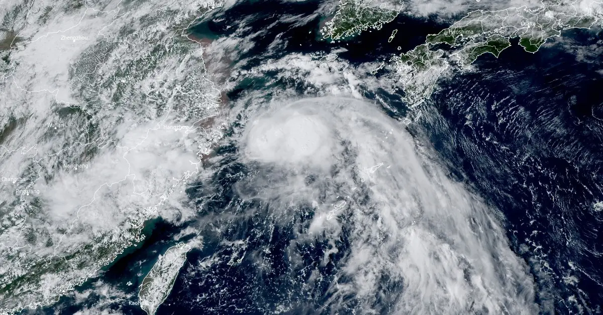
Featured image: 30 UTC on September 19, 2024. Credit: Himawari-9, RAMMB/CIRA, The Watchers
Pulasan made its way across Okinawa, Japan, on Wednesday night, leaving behind a trail of varied impacts. According to Meteorologist Robert Speta of WestPacWX, the storm was not well-organized, likened to “scrambled eggs” due to its scattered nature.
The storm’s right side experienced the most severe weather, with wind speeds reaching up to 96 km/h (60 mph) in certain areas such as Yoron.
As Pulasan moves towards Shanghai, it is expected to make landfall south of the city on Thursday, September 19. While the storm is not as intense as Typhoon “Bebinka” — which recently battered the region, it poses a significant concern due to the potential for further damage in the area, still recovering from the previous storm.

Speta emphasized that the impact on China is heavily dependent on the storm’s track and position relative to its center of circulation.
While Okinawa and the southern Japanese islands can expect more rain and shifting winds in the coming days, a cold surge seems to be developing further north, hinting at the onset of colder weather.
According to the JTWC Prognostic Reasoning released at 03:00 UTC on September 19, Pulasan (15W) is forecast to continue tracking northwestward along the periphery of the subtropical ridge to the northeast through 03:00 UTC on September 20. Around that time, Pulasan is anticipated to make landfall near Shanghai, as a trough begins to break down an extension of the ridge, creating a weak steering environment and causing very slow track speeds.
By 15:00 UTC on September 20, Pulasan is expected to start tracking east-northeastward as the ridge takes over as the primary steering influence once again. Around 03:00 UTC on September 21, track speeds are expected to increase significantly due to interaction with the jet stream, marking the beginning of its extratropical transition.
The system will then move briskly along the southern coast of South Korea through the Korea Strait and into the Sea of Japan.
As a result of the baroclinic zone being pushed south by the trough, Pulasan is forecast to complete its extratropical transition quickly by 03:00 UTC on September 22.
Regarding intensity, Pulasan is expected to gradually weaken as it approaches Shanghai, where it makes landfall as a borderline tropical storm. Once the system moves back over water, a steady intensification trend will follow; however, strong vertical wind shear will limit the intensity to a peak of 75 km/h (46 mph).
References:
1 Tropical Storm 15W (Pulasan) Warning #10 – JTWC – Issued at 03:00 UTC on September 19, 2024
I'm a dedicated researcher, journalist, and editor at The Watchers. With over 20 years of experience in the media industry, I specialize in hard science news, focusing on extreme weather, seismic and volcanic activity, space weather, and astronomy, including near-Earth objects and planetary defense strategies. You can reach me at teo /at/ watchers.news.
Commenting rules and guidelines
We value the thoughts and opinions of our readers and welcome healthy discussions on our website. In order to maintain a respectful and positive community, we ask that all commenters follow these rules.