
Hurricane “Ernesto” expected to hit Bermuda with dangerous storm surge and flash flooding
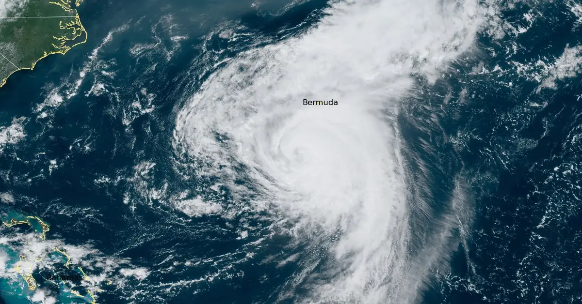
Featured image: Hurricane "Ernesto" at 16:30 UTC on August 16, 2024. Credit: NOAA/GOES-East, RAMMB/CIRA, The Watchers
Bermuda is bracing for potentially life-threatening conditions as Category 2 Hurricane “Ernesto” approaches the island, bringing strong winds, dangerous storm surges, and severe flooding starting Friday, August 16, 2024.
- On the forecast track, the center of Ernesto is expected to pass near or over Bermuda on Saturday morning (LT), August 17.
- Ernesto is expected to bring a prolonged period of strong winds and storm surge on Bermuda starting this afternoon through Saturday night, August 17. A hurricane warning is in effect for the island, and preparations to protect life and property should be rushed to completion.
- Heavy rainfall associated with Ernesto is expected to impact Bermuda through this weekend and will likely result in considerable life-threatening flash flooding, especially in low-lying areas on the island.
- Even though Ernesto is forecast to remain well offshore the U.S. East Coast, swells generated by the hurricane are expected to affect the area through the weekend. Beachgoers should be aware of a significant risk of life-threatening surf and rip currents, and stay out of the water if advised by lifeguards.
- Surf and rip currents are also possible on the Turks and Caicos, the Bahamas, Bermuda, and Atlantic Canada during the next few days.
Bermuda is expected to experience strong winds, dangerous storm surges, and life-threatening flooding as Category 2 Hurricane Ernesto approaches on Friday.
A few days ago, Ernesto impacted the Caribbean as a strong tropical storm. Puerto Rico and the U.S. Virgin Islands experienced flash flooding, water rescues, power outages, and infrastructure damage due to the storm.
“While Bermuda has been fortunate in recent years to avoid the worst impacts of hurricanes, we must take each storm seriously and prepare accordingly,” said Bermuda’s Minister of National Security, Hon. Michael Weeks, JP, MP, during a news conference.
“As I’ve said before, it only takes one storm to cause significant damage and disrupt our way of life,” he added. Weeks warned that Ernesto’s winds, rain, and flooding would likely result in power outages across the islands.
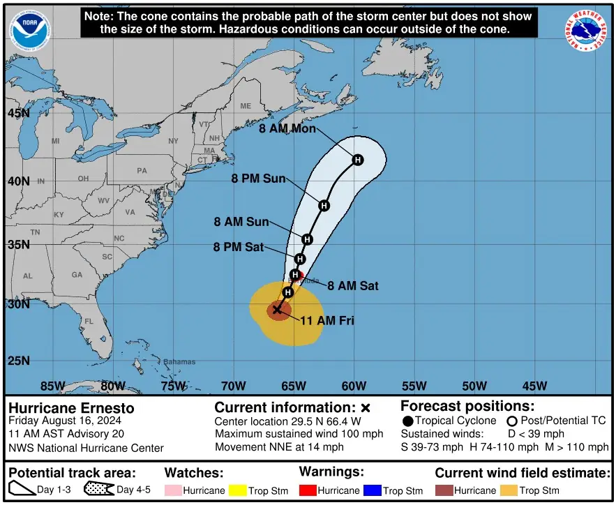
According to the latest advisory from the National Hurricane Center (NHC), as of 15:00 UTC, the center of Hurricane “Ernesto” was located 345 km (215 miles) SSW of Bermuda.
The hurricane is moving north-northeast at approximately 22 km/h (14 mph) with maximum sustained winds of 155 km/h (100 mph). This movement is expected to continue while gradually slowing down until Saturday, August 17.
A faster northeastward motion is anticipated late in the weekend, with the center of Ernesto expected to pass near or over Bermuda on Saturday morning.
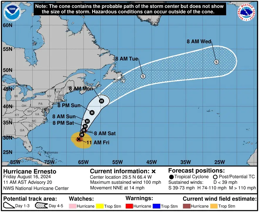

Some gradual weakening is forecast for Saturday, though re-intensification is possible by early next week.
Ernesto is expected to bring a prolonged period of strong winds and storm surge to Bermuda starting Friday afternoon and continuing through Saturday night. A hurricane warning is in effect for the island, and preparations to protect life and property should be completed urgently.
The system is expected to produce total rainfall accumulations of 150 – 300 mm (6 – 12 inches) in Bermuda, with isolated maximum amounts up to 380 mm (15 inches). This rainfall will likely result in considerable life-threatening flash flooding, especially in low-lying areas on the island.
Ernesto is forecast to remain well offshore from the U.S. East Coast, but swells generated by the hurricane are expected to affect the region throughout the weekend.
1st light, Astwood Cove, South Shore
— Robert Walnut (@bobbywalnut) August 16, 2024
—@wxchanneldesk @weatherchannel @StoryfulNews @SpecteeNews1 @WeatherNation @AccuWeather @guardian @AccuweatherUGC @CNNweather
…#HurricaneErnesto #HurricaneSeason2024 #HurricaneSeason #ClimateCrisis #Hurricane #storm #Bermuda #lostyetfound pic.twitter.com/qEaEgbkRWJ
Surf's up! Rough waves and rip currents are expected all weekend and into Monday because of a stiff south breeze & Ernesto in the Atlantic
— Alex Calamia ☀️ (@AlexCalamiaWx) August 16, 2024
Hurricane Ernesto will pass WAY east (at least 500 miles east!) of Long Island on Sunday
DETAILS: https://t.co/nSVUJMv9wM#NYwx #LongIsland pic.twitter.com/4krvHZgA95
There will be a significant risk of life-threatening surf and rip currents near beaches. Surf and rip currents are also possible in the Turks and Caicos, the Bahamas, Bermuda, and Atlantic Canada over the next few days.
References:
1 Hurricane Ernesto Public Advisory – NHC – August 16, 2024
2 Hurricane Ernesto Forecast Discussion – NHC – August 16, 2024
3 Bermuda braces for Category 2 Hurricane Ernesto that’s packing 100-mph winds – Fox Weather – August 14, 2024

I am an Assistant Editor and Severe Weather & Science Journalist at The Watchers, specializing in real-time severe weather coverage, geophysical event reporting, and research-driven scientific analysis. You can reach me at rishav(at)watchers(.)news.
Commenting rules and guidelines
We value the thoughts and opinions of our readers and welcome healthy discussions on our website. In order to maintain a respectful and positive community, we ask that all commenters follow these rules.