
Increased seismic activity in Svartsengi, Iceland signals new volcanic eruption

Image credit: IMO
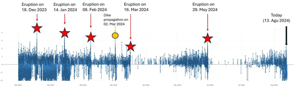
Rising seismic activity and land deformation patterns in Iceland’s Svartsengi area resemble those observed before the last eruption in the Sundhnúkur crater row, indicating a potential for a new volcanic eruption in the near term.
Seismic activity in the region has significantly increased over the past few weeks, with daily earthquake counts ranging from 60 to 80. Most of these earthquakes have occurred at depths of 2 – 4 km (1.2 – 2.5 miles), particularly between the Stóra-Skógfell and Grindavík regions.
These patterns are similar to those observed before previous magma movements and volcanic eruptions in the region, indicating an elevated risk of volcanic eruption.
In the latest update, released by the Icelandic Meteorological Office (IMO) on August 13, volcanologists estimated that the volume of magma accumulating beneath Svartsengi exceeds 20 million m3 (706 million ft3) since the last eruption, which began on May 29.
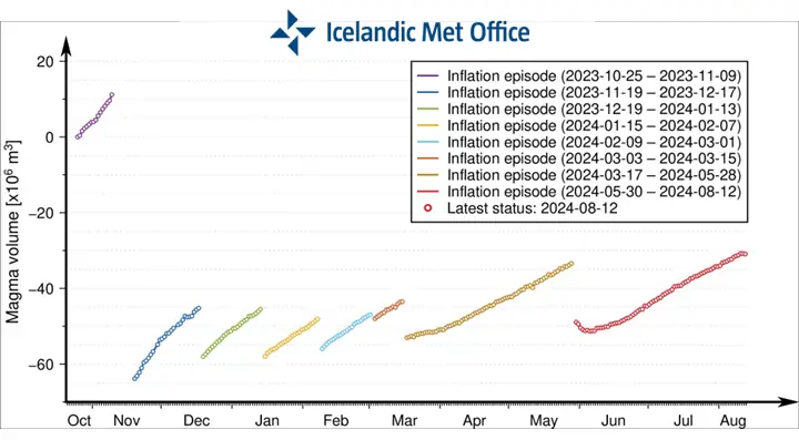
This accumulation is accompanied by ongoing land uplift, albeit at a slower rate than previously observed. The continued deformation suggests increasing magma pressure beneath Svartsengi.
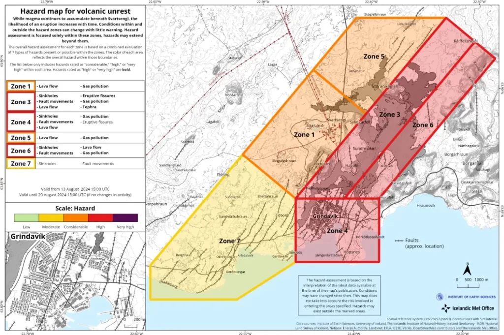
Despite the increased activity, the IMO’s hazard assessment remains unchanged from the previous week and will stay in effect until August 20.
The report outlines two primary scenarios for potential volcanic activity:
Scenario 1:
An eruption between Stóra-Skógfell and Sundhnúkur could occur with little warning, with a pre-eruption warning time potentially being less than 30 minutes. Lava could reach Grindavíkurvegur near Þorbjörn within 1.5 hours and Grindavíkurvegur near Svartsengi within 3 hours.
Scenario 2:
The likely precursor to this scenario could be an earthquake swarm starting near Stóra-Skógfell or Sýlingarfell and moving southwards, along with accelerated deformation and pressure variations in local boreholes.
The warning interval for the eruption could be longer than in Scenario 1, but its exact duration is uncertain and depends on the distance the magma travels to breach the surface. Once erupted, lava is expected to reach Nesvegur and Suðurstrandarvegur within approximately 1.5 hours and could block key escape routes on land within around 6 hours.
Lava could reach the sea east of Grindavík within 1.5 – 3 hours. The rapid cooling of lava upon entering the sea may lead to localized hazards, such as the release of ash and harmful gases like hydrochloric acid (HCl), making conditions within a 500 m (1 640 feet) radius life-threatening.
A magma intrusion that reaches south of Hagafell will likely cause significant fault movements in Grindavík. There is a possibility that lava could erupt within Grindavík. One scenario is that lava erupting from a vent north of the protective barriers at Grindavík could flow into existing fissures and then re-emerge within the town limits. Another scenario is the possibility of an eruptive fissure opening within Grindavík. However, in such a situation, a fissure would likely first open north of the town before opening within the town limits.
References:
1 Geophysical measurements show similar trend as before the last eruption on the Sundhnúkur crater row – IMO – August 13, 2024

I am an Assistant Editor and Severe Weather & Science Journalist at The Watchers, specializing in real-time severe weather coverage, geophysical event reporting, and research-driven scientific analysis. You can reach me at rishav(at)watchers(.)news.
Commenting rules and guidelines
We value the thoughts and opinions of our readers and welcome healthy discussions on our website. In order to maintain a respectful and positive community, we ask that all commenters follow these rules.