
SAR data shows persistent ground deformation at Tanzania’s Ol Doinyo Lengai volcano
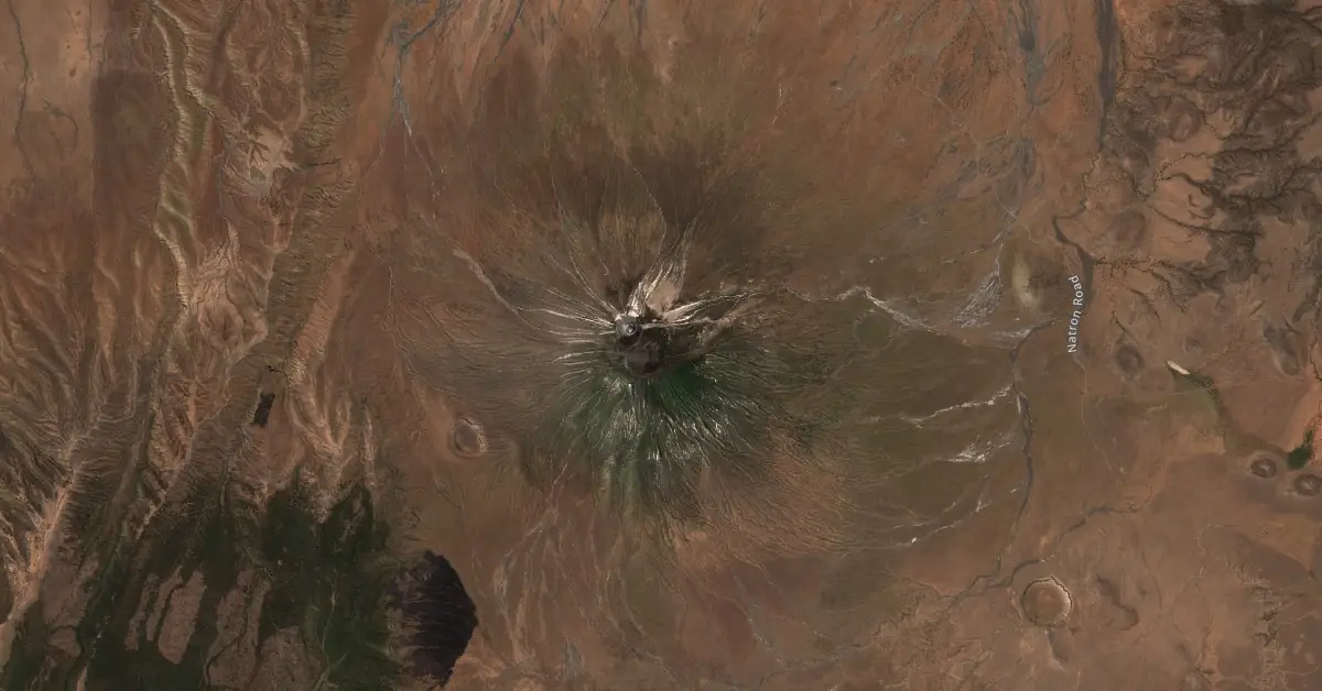
Image credit: AGU/Authors
A new study observed significant ground deformation around Ol Doinyo Lengai’s summit crater in Tanzania. The research suggests that the steady subsidence is due to a deflating magma reservoir less than 1 km (0.6 miles) below the surface.
A decade-long study using Synthetic Aperture Radar (SAR) data has revealed significant ground deformation around the summit crater of Ol Doinyo Lengai in Tanzania, the only active carbonatitic volcano on Earth. The findings indicate steady ground subsidence likely due to a deflating shallow magma reservoir beneath the summit.
The study analyzed hundreds of SAR images acquired by two satellite systems, Sentinel-1 and COSMO-SkyMed, over 10 years. Sentinel-1 data spanned from 2015 to 2023 in ascending orbits and from 2018 to 2021 in descending orbits, while COSMO-SkyMed provided data for 2013 – 2014.
The Interferometric Synthetic Aperture Radar (InSAR) time series revealed a 0.5 km (0.31 miles) diameter subsiding area around the summit crater, with ground subsidence occurring at an average rate of approximately 3.6 cm (1.4 inches) per year.
The deformation was predominantly observed on the northern upper slopes of the volcano. By decomposing ascending and descending orbits, researchers identified the vertical and east-west components of the ground displacement. The primary finding showed that most of the subsidence was vertical, averaging a rate of 3.6 cm (1.4 inches) per year.
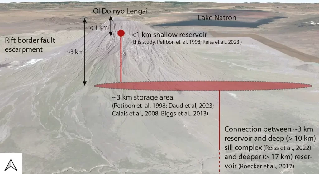
The ground subsidence is attributed to a deflating magma reservoir located at a depth of less than 1 km (0.62 miles) below the summit crater. This conclusion is supported by geodetic modeling using the highest spatial resolution COSMO-SkyMed data set. The model indicates a volume decrease of approximately 19 000 cubic meters (670 000 cubic feet) in the magma reservoir.
Ol Doinyo Lengai, situated in the Natron Basin of the Eastern Branch of the East African Rift, is unique for its effusive and explosive eruptions of carbonatitic lava. The region experienced significant seismic and magmatic unrest between 2007 and 2008, which included the formation of a new summit cone following explosive eruptions.
Since the 2007 – 2008 eruptions, the summit has undergone various effusive eruptions. A fissure below the western rim of the summit crater, first discovered in 2013, has expanded significantly, measuring over 100 m (328 feet) long as of 2021.
The study’s geodetic modeling aligns with recent seismic and acoustic data, suggesting a very shallow magma reservoir directly beneath the summit crater.
The findings suggest a need for further investigation into the geometry and characteristics of the magma plumbing system. Advanced numerical modeling could provide a more detailed understanding of the magma reservoir’s shape, depth, volume changes, and interactions with potential ring fault systems.
References:
1 Satellite Geodesy Unveils a Decade of Summit Subsidence at Ol Doinyo Lengai Volcano, Tanzania – Christelle Wauthier, Cristy Ho – AGU Geophysical Research Letters – June 8, 2024 – https://doi.org/10.1029/2023GL107673 – OPEN ACCESS

I am an Assistant Editor and Severe Weather & Science Journalist at The Watchers, specializing in real-time severe weather coverage, geophysical event reporting, and research-driven scientific analysis. You can reach me at rishav(at)watchers(.)news.
Commenting rules and guidelines
We value the thoughts and opinions of our readers and welcome healthy discussions on our website. In order to maintain a respectful and positive community, we ask that all commenters follow these rules.