
Heavy rains and landslides hit Central America, claiming 13 lives in El Salvador and Guatemala
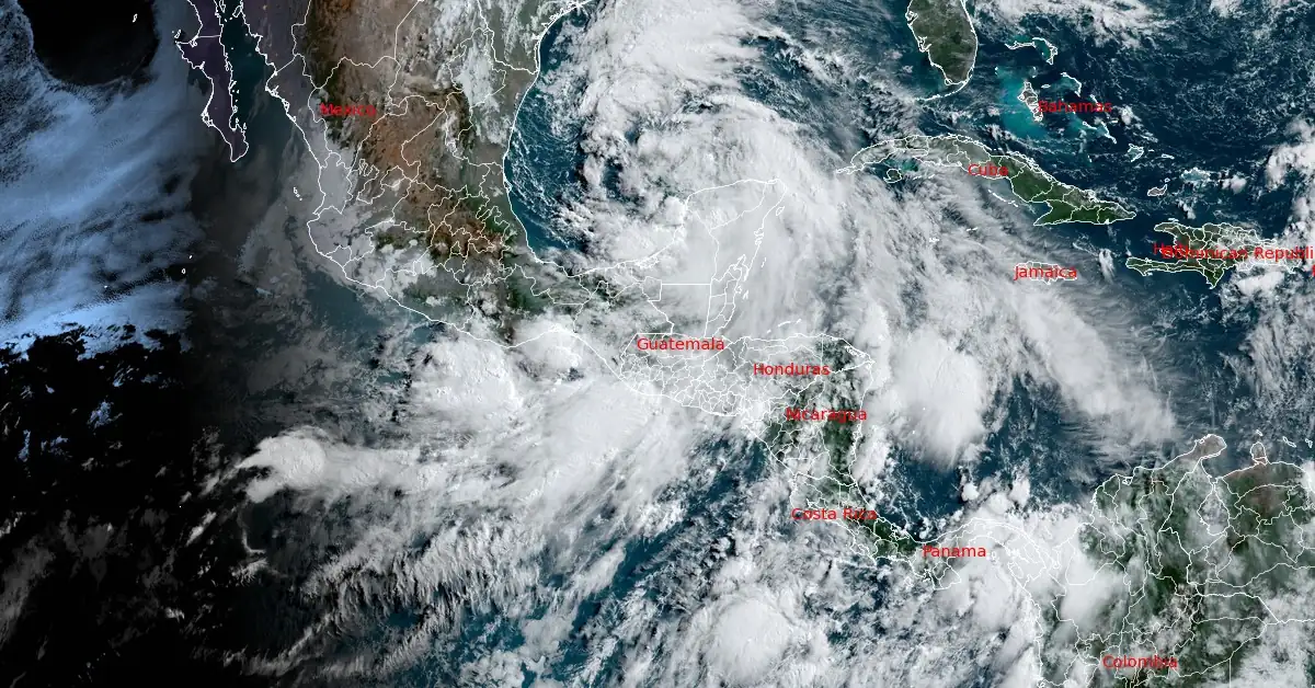
Image credit: NOAA/GOES-East, RAMMB/CIRA, The Watchers. Acquired at 13:20 UTC on June 18, 2024
Relentless heavy rains caused by low-pressure systems on Guatemala’s Pacific coast and in the Gulf of Mexico have resulted in floods and landslides across Central America, leaving at least 13 people dead since Saturday, June 15, 2024. The worst affected are Guatemala and El Salvador, where a state of emergency has been declared.
Central America faces the brunt of heavy rains that began over the weekend, triggering deadly landslides and floods in El Salvador and Guatemala. At least 13 people have been confirmed dead across the region, with El Salvador being the hardest-hit country so far. The Government of El Salvador has declared a state of emergency in the country.
El Salvador’s civil defense chief, Luis Amaya, reported five deaths on June 17 due to a landslide in the western district of Tacuba. Two of the victims were identified as minors.
The rising death toll follows earlier reports of fatalities, including one person killed in a landslide on June 15 and another on June 16 when a tree fell on a vehicle.
#SanMarcos Reportan deslizamiento en aldea San Jerónimo del municipio de El Tumbador, San Marcos lo que generó daños en vivienda ubicada en el área.
— CONRED (@ConredGuatemala) June 18, 2024
Créditos: Franz Kiss, Técnico de Campo de la SE-CONRED. pic.twitter.com/12xKLPe5fQ
#Quiché Derrumbe es reportado en aldea La Estancia del municipio de Santa Cruz del Quiché. Se coordinan trabajos de limpieza.
— CONRED (@ConredGuatemala) June 18, 2024
Créditos: Eladio Xirum, Delegado Departamental de la SE-CONRED. pic.twitter.com/iHFLz7WsAz
The heavy rains are attributed to low-pressure systems on Guatemala’s Pacific coast and the Gulf of Mexico, which have been relentless since Saturday.
Fearing further flooding, El Salvador’s government declared a state of emergency on Sunday and opened over 100 shelters across the country. Schools will remain closed on Tuesday and Wednesday due to the continued threat of rain.
President Nayib Bukele stated that he had asked Congress to declare a federal holiday on Tuesday.
In a press conference, Luis Amaya urged residents to prioritize their safety. “If you are asked to evacuate, do it,” he said. “If you live near a slope, move to a safe area. The number one priority is to be safe.”
Guatemala is also facing heavy rains. Authorities confirmed the deaths of a man and a woman in the village of Chacaya after a wall collapsed on them. As a precaution, schools in Guatemala will be closed until Thursday, June 10.
The heavy rains extended beyond Central America. In Ecuador’s Tungurahua province, a landslide on a highway tragically claimed the lives of seven people, injuring several others. Honduran authorities have begun evacuations in anticipation of the rains affecting around 5 000 people.
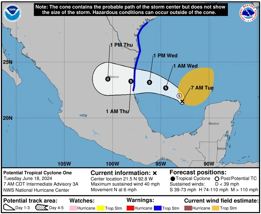
One of the systems affecting the region, now designated as Potential Tropical Cyclone One, prompted the government of Mexico to upgrade the Tropical Storm Watch for the northeastern coast of Mexico south of the mouth of the Rio Grande to Puerto de Altamira to a Tropical Storm Warning on June 18.
As of 12:00 UTC on June 18, the center of this system was located about 575 km (355 miles) ESE of La Pesca, Mexico, and 680 km (420 miles) SE of Brownsville, Texas.
The system had maximum sustained winds of 65 km/h (40 mph) and a minimum central pressure of 999 hPa. It was moving N at 9 km/h (6 mph).
A Tropical Storm Warning is in effect for the Texas coast from Port O’Connor southward to the mouth of the Rio Grande, and for the northeastern coast of Mexico south of the mouth of the Rio Grande to Puerto de Altamira. A Tropical Storm Warning means that tropical storm conditions are expected somewhere within the warning area within 36 hours.
Tropical storm landfall in Mexico
An increase in strength is likely during the next 36 hours, and the disturbance is forecast to become a tropical storm by Wednesday, June 19 and make landfall in Mexico late Wednesday to early Thursday, June 12.
This would be the first named storm of the 2024 Atlantic hurricane season — Alberto. NOAA’s outlook for this season, running from June 1 to November 30, predicts an 85% chance of an above-normal season, a 10% chance of a near-normal season and a 5% chance of a below-normal season. NOAA is forecasting a range of 17 to 25 total named storms.
The disturbance is quite large with tropical-storm-force winds extending outward up to 465 km (290 miles) to the northeast of the center.
The combination of dangerous storm surge and high tides is expected to cause flooding in typically dry areas near the coast. Water levels could reach the following heights above ground in the specified areas if the peak surge occurs at high tide:
- Sargent, TX to Sabine Pass, TX: 0.6 to 1.2 m (2 to 4 feet)
- Galveston Bay: 0.6 to 1.2 ms (2 to 4 feet)
- Mouth of the Rio Grande, TX to Sargent, TX: 0.3 to 0.9 m (1 to 3 feet)
- Sabine Pass, TX to Vermilion/Cameron Parish Line, LA: 0.3 to 0.9 m (1 to 3 feet)
The highest water levels are expected along the immediate coast near and north of the landfall location, accompanied by large and dangerous waves. The extent of surge-related flooding depends on the timing of the surge and tidal cycles and can vary significantly over short distances.
In Mexico, minor coastal flooding is expected north of where the center of the system makes landfall, particularly in areas experiencing onshore winds.
Tropical storm conditions are anticipated in the warning area by Wednesday, bringing strong winds and the potential for damage to property and infrastructure.
Residents in the affected areas are advised to stay informed through local weather updates and follow any instructions from emergency management officials to ensure their safety.
References:
1 At least 13 killed in Central America as heavy rains trigger floods, landslides – France 24 – June 18, 2024
2 Central America: Torrential rains kill several people – DW – June 18, 2024
3 7 people die in events related to heavy rains in El Salvador – AP – June 18, 2024
4 Potential Tropical Cyclone One – Intermediate Advisory Number 3A – NWS/NHC – 700 AM CDT Tue Jun 18 2024

I am an Assistant Editor and Severe Weather & Science Journalist at The Watchers, specializing in real-time severe weather coverage, geophysical event reporting, and research-driven scientific analysis. You can reach me at rishav(at)watchers(.)news.
Commenting rules and guidelines
We value the thoughts and opinions of our readers and welcome healthy discussions on our website. In order to maintain a respectful and positive community, we ask that all commenters follow these rules.