
High Risk of Excessive Rainfall issued for the I-75 Corridor, Florida
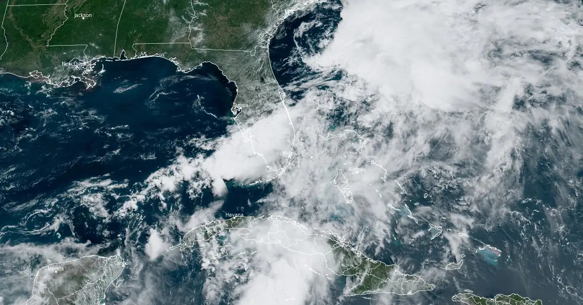
Image credit: NOAA/GOES-East, RAMMB/CIRA, The Watchers. Acquired at 15:40 UTC on June 13, 2024
A High Risk of Excessive Rainfall (level 4/4 risk) is now in effect across parts of South Florida, including the Miami metro region, the NWS Weather Prediction Center said at 13:00 EST (17:00 UTC) on June 13, 2024
- Heavy rainfall is expected over very sensitive locations still recovering from yesterday’s flooding.
- Additional heavy rainfall over very saturated soil and urban regions will likely create new rounds of flash flooding today over southern Florida.
A High Risk of Excessive Rainfall (level 4/4 risk) has been issued for the I-75 Corridor. “This means that widespread flash flooding is expected while locally catastrophic flooding is possible,” meteorologists at the NWS office in Miami said.
Additional totals of 50 – 125 mm (2 – 5 inches) are likely with locally as high as and over 250 mm (10 inches) in isolated locations along the southwest coastal areas extending through the interior of the Florida Peninsula.
(06-13 at 12:25 PM): A strong line of deep cold convection is moving through Glades and Hendry counties. As the afternoon progresses, strong thunderstorms will continue to the SE and bring torrential downpours to areas that have already seen flooding. #MFLWx pic.twitter.com/rfGEN929jt
— NWS Miami (@NWSMiami) June 13, 2024
Widespread floods are expected, especially in the High Risk area, highlighted in pink in the image below.

A Flash Flood Emergency was issued on Wednesday afternoon (LT) for portions of Broward and Miami-Dade counties as downpours flooded the roads and floated vehicles, causing delays in transportation and rescue operations.
Residents were urged not to travel unless necessary.
Some humbling footage of stranded cars in Miami amidst a state of emergency from Wednesday's Floridian flooding. Don't get stranded as inundation persists today. Remember, "Turn Around, Don't Drown!"
— WeatherBug (@WeatherBug) June 13, 2024
Credit: Anasstasiya Skrund via Storyful pic.twitter.com/NbOzLKpBnq
In Sarasota, over 261.6 mm (10.3 inches) was recorded in 24 hours on June 11. Of this total, 99.8 mm (3.93 inches) fell between 19:00 and 20:00 EDT, setting a new record for one-hour rainfall. Weather records in Sarasota have been maintained since 1972.
“Statistically, getting this much rain in such a short time is about a 1 : 1,000 year flood for this part of Florida,” said meteorologist Noah Bergren. “That does not mean it happens one only every thousand years, but the chance in any given year is around 0.1%!”
I'm a dedicated researcher, journalist, and editor at The Watchers. With over 20 years of experience in the media industry, I specialize in hard science news, focusing on extreme weather, seismic and volcanic activity, space weather, and astronomy, including near-Earth objects and planetary defense strategies. You can reach me at teo /at/ watchers.news.
Commenting rules and guidelines
We value the thoughts and opinions of our readers and welcome healthy discussions on our website. In order to maintain a respectful and positive community, we ask that all commenters follow these rules.