
Widespread floods in South Florida, authorities urge citizens to refrain from travel
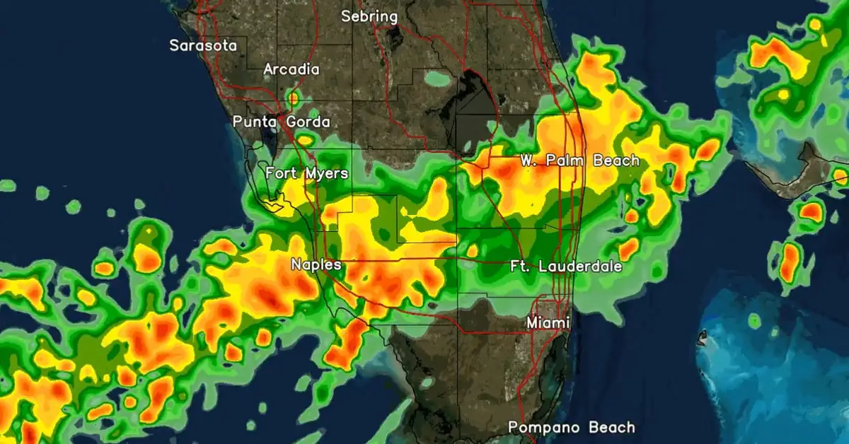
Image credit: NWS
As the long low pressure region near the coast of Florida continued producing a wide area of disorganized showers and thunderstorms, SE Broward and NE Miami-Dade including Hallandale, Hollywood, NMB, Dania, and Aventura witnessed life-threatening flooding and widespread road closures with detrimental impact on homes and businesses across the region.
The disturbance responsible for heavy to record-breaking rains has not reached cyclone status and was given only a slight chance to form into a tropical system once it emerged into the Atlantic Ocean after crossing Florida, according to the National Hurricane Center (NHC).
“Despite strong upper-level winds, some gradual development is possible while the system moves northeastward offshore of the southeastern U.S. coast during the next couple of days. Regardless of development, heavy rainfall is forecast to continue across portions of the Florida through late this week,” NWS forecaster Reinhart, noted on Thursday, June 13.
A Flash Flood Emergency was issued on Wednesday afternoon (LT) for portions of Broward and Miami-Dade counties as downpours flooded the roads and floated vehicles, causing delays in transportation and rescue operations.
Residents were urged not to travel unless necessary.
Jun 12 @ 615 PM – Portions of SE Broward & NE Miami-Dade including Hallandale, Hollywood, NMB, Dania, Aventura continue to see life-threatening flooding with widespread road closures & impacts to homes/businesses. Please stay put if you do not need to travel! #FLwx https://t.co/NfPV86DBZI
— NWS Miami (@NWSMiami) June 12, 2024
Continuous rainfall is causing flash flooding on Collins Ave. and interior streets causing disabled vehicles on the roadway. Please stay home or in a safe area. Do NOT drive through flooded streets. pic.twitter.com/jt93urOBSq
— City of Sunny Isles Beach (@CityofSIB) June 12, 2024
Martin County Fire Rescue reported an EF-1 tornado on Wednesday morning damaged parts of Hobe Sound, Florida, about 40 km (25 miles) north of West Palm Beach. Some homes sustained damage, and power outages were reported in several neighborhoods.
According to FlightAware, 153 flights departing Miami International and 149 flights arriving at Fort Lauderdale International, equivalent to 34% of arrivals, were canceled. Additionally, hundreds of flights were delayed at both airports.
“High water vehicles are deployed strategically around the city and ready to respond as needed,” Fort Lauderdale officials said in a post on X, urging citizens to avoid driving if possible.
Fort Lauderdale and Miami-Dade County mayors declared a state of emergency, while Florida’s governor declared emergencies in Miami-Dade, Broward, Collier, Lee, and Sarasota counties.
Due to continued heavy rainfall, there is high water on some roadways across the City, including major thoroughfares like Broward Boulevard and Federal Highway near downtown.
— City of Fort Lauderdale (@FTLCityNews) June 12, 2024
City emergency management staff is actively monitoring the situation and deploying resources across the… pic.twitter.com/53KfOHblzu
An additional round of heavy rainfall is forecast across South Florida on Thursday, June 13, as a large convective band of showers and thunderstorms develops and moves southward for the third day in a row.
“Even a small duration of heavy rainfall could lead to more flash flooding,” meteorologists at the NWS Miami said.
: Today's Forecast Concerns!
— NWS Miami (@NWSMiami) June 13, 2024
An additional round of heavy rainfall is forecast across SFL today as a large convective band of showers & thunderstorms develops & move southward for the 3rd day in a row. Even a small duration of heavy rainfall could lead to more flash flooding! pic.twitter.com/n2MSwzkp3F
In addition, a broad area of low pressure is forecast to form over the southwestern Gulf of Mexico this weekend.
Environmental conditions appear conducive for gradual development, and a tropical depression could form early to mid-next week as it moves slowly westward or west-northwestward. The formation chance through 48 hours is near 0 percent, while the formation chance through seven days is 40%.
References:
1 Tropical weather outlook – NWS NHC – June 13, 2024
2 Flood Watch – NWS Miami – June 13, 2024
3 Flash Flood Emergency issued for parts of South Florida as tropical disturbance 90L crosses state – FOX Weather – June 13, 2024

I am an Assistant Editor and Severe Weather & Science Journalist at The Watchers, specializing in real-time severe weather coverage, geophysical event reporting, and research-driven scientific analysis. You can reach me at rishav(at)watchers(.)news.
Commenting rules and guidelines
We value the thoughts and opinions of our readers and welcome healthy discussions on our website. In order to maintain a respectful and positive community, we ask that all commenters follow these rules.