
Nearly 5 000 earthquakes hit Reykjanes Peninsula in 2 days, Iceland
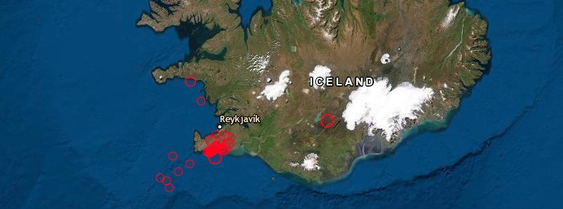
Image credit: EMSC
Nearly 5 000 earthquakes have been registered in two distinct clusters on Reykjanes Peninsula, Iceland since February 24, 2021.
The swarm includes two earthquakes above M5.0 — M5.7 at 10:05 UTC and M5.0 at 10:30 UTC, the Icelandic Met Office (IMO) reported at 09:05 UTC on February 26. The quakes were followed by M4.8 near Kleifarvatn at 12:37 UTC.
The IMO's SIL system has detected 11 earthquakes over M4.0 and many larger than M3.0. The earthquakes have been felt all over the SV-part of Iceland, north to Húnaþing and west to Ísafjörður.
This morning at 08:37 UTC an earthquake of M3.2 occurred just 2 km (1.2 miles) E of Fagradalsfjall and was felt in the surrounding area.
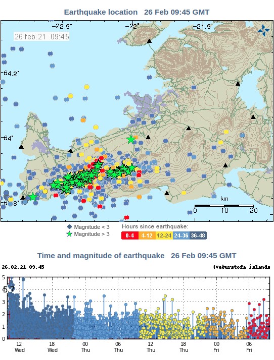
The swarm is still ongoing and since February 24 the SIL system has detected around 5 000 earthquakes in the area, IMO said.
Due to the ongoing seismic activity, people are advised to avoid steep terrain as rocks and boulders can fall and the chances of landslides are increased.
The current activity on the Reykjanes peninsula, which can in fact be traced back more than a year, has been divided into sections and it is difficult to predict the exact development, but these two scenarios are primarily looked at:
- Seismic activity reduces in the next few days or weeks.
- The activity increases with larger earthquakes, up to M5.5 – 6.5.
Read more:
- Large-scale volcano-tectonic reactivation event in the Reykjanes peninsula, satellites map surface deformation, Iceland (Published July 24, 2020)
- M5.6 earthquake hits Reykjanes peninsula, the largest since 2003, Iceland (Published October 21, 2020)
- TW Tag: Reykjanes peninsula
Geological summary
The Reykjanes volcanic system at the SW tip of the Reykjanes Peninsula, where the Mid-Atlantic Ridge rises above sea level, comprises a broad area of postglacial basaltic crater rows and small shield volcanoes.
The submarine Reykjaneshryggur volcanic system is contiguous with and is considered part of the Reykjanes volcanic system, which is the westernmost of a series of four closely-spaced en-echelon fissure systems that extend diagonally across the Reykjanes Peninsula.
Most of the subaerial part of the volcanic system (also known as the Reykjanes/Svartsengi volcanic system) is covered by Holocene lavas.
Subaerial eruptions have occurred in historical time during the 13th century at several locations on the NE-SW-trending fissure system, and numerous submarine eruptions at Reykjaneshryggur dating back to the 12th century have been observed during historical time, some of which have formed ephemeral islands.
Basaltic rocks of probable Holocene age have been recovered during dredging operations, and tephra deposits from earlier Holocene eruptions are preserved on the nearby Reykjanes Peninsula. (GVP)
I'm a dedicated researcher, journalist, and editor at The Watchers. With over 20 years of experience in the media industry, I specialize in hard science news, focusing on extreme weather, seismic and volcanic activity, space weather, and astronomy, including near-Earth objects and planetary defense strategies. You can reach me at teo /at/ watchers.news.
Commenting rules and guidelines
We value the thoughts and opinions of our readers and welcome healthy discussions on our website. In order to maintain a respectful and positive community, we ask that all commenters follow these rules.