
Large-scale volcano-tectonic reactivation event in the Reykjanes peninsula, satellites map surface deformation, Iceland
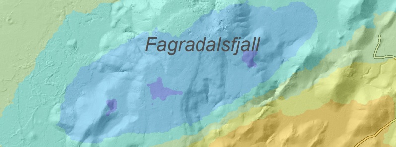
Image credit: IMO
Intense earthquake swarm that started in Fagradalsfjall, Iceland's Reykjavik peninsula on July 18, 2020, is slowly decreasing over time, the Icelandic Met Office (IMO) reports. The current earthquake activity is interpreted to be part of a larger scale volcano-tectonic reactivation event in the Reykjanes peninsula.
The acquisition of recent satellite images enabled the mapping of new surface deformation in the area associated with the sequence of large earthquakes that occurred from July 18 to 20.
"The satellite data processing clearly shows a deformation signal corresponding to approximately 3 cm (1.18 inches) of movement along a NE-SW oriented fault in the region of Fagradalsfjall," IMO stated, adding that this fault was identified during the 2017 earthquake swarm which also occurred in this area.
The images acquired during the period also reveal a localized subsidence signal in the Svartsengi area. The observed subsidence commenced between July 16 and 18, slightly before the occurrence of the large tectonic earthquakes in Fagradalsfjall.
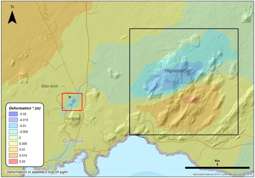
Interferometric synthetic aperture radar (InSAR) image obtained using Sentinel satellite data, covering the period July 16 – 22, 2020.Image credit: IMO
The next satellite image, expected at the end of this week, will confirm if the deflation is still ongoing or if this has stopped. In addition, deformation modeling will be undertaken to verify the origin of this signal.
No significant changes are reported regarding the geochemical measurements performed this week. Additionally, the geothermal power plant in Svartsengi reports no changes in their routine measurements.
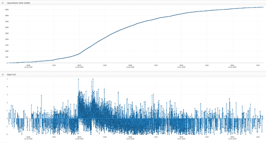
Image credit: IMO
"The ongoing activity on the Reykjanes peninsula, which commenced at the end of 2019, reflects a widespread volcano-tectonic reactivation of a large section of the peninsula, currently spanning Eldey in the west to Krýsuvík in the east," IMO specialists concluded.
This activity, including additional earthquakes and magmatic intrusions, is likely to continue, with the focus switching between different areas along the peninsula.
Possible hazards, as determined by IMO:
- Landslides and falling rocks might be triggered by earthquakes, most likely in regions with unstable slopes, steep cliffs, and loose material
- Earthquakes up to M5.5 – 6 might occur in areas along the Reykjanes peninsula with the potential to affect the capital region
- Gas accumulation in depressions might occur in the event of very still wind conditions
Geological summary
The Reykjanes volcanic system at the SW tip of the Reykjanes Peninsula, where the Mid-Atlantic Ridge rises above sea level, comprises a broad area of postglacial basaltic crater rows and small shield volcanoes.
The submarine Reykjaneshryggur volcanic system is contiguous with and is considered part of the Reykjanes volcanic system, which is the westernmost of a series of four closely-spaced en-echelon fissure systems that extend diagonally across the Reykjanes Peninsula.
Most of the subaerial part of the volcanic system (also known as the Reykjanes/Svartsengi volcanic system) is covered by Holocene lavas.
Subaerial eruptions have occurred in historical time during the 13th century at several locations on the NE-SW-trending fissure system, and numerous submarine eruptions at Reykjaneshryggur dating back to the 12th century have been observed during historical time, some of which have formed ephemeral islands.
Basaltic rocks of probable Holocene age have been recovered during dredging operations, and tephra deposits from earlier Holocene eruptions are preserved on the nearby Reykjanes Peninsula. (GVP)
I'm a dedicated researcher, journalist, and editor at The Watchers. With over 20 years of experience in the media industry, I specialize in hard science news, focusing on extreme weather, seismic and volcanic activity, space weather, and astronomy, including near-Earth objects and planetary defense strategies. You can reach me at teo /at/ watchers.news.
Will anyone investigate the fact that geothermal operations lubricate faults and destabilize the ground many kilometers away? Or will it get swept under the rug like the 2018 Kilauea eruption in Hawaii where you can’t get one scientist to make a chart of the earthquakes and locations and discuss it…..