
Severe storm brings massive rains to Queensland and NSW, Australia
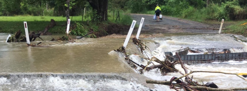
Image credit: NSW SES
An intense low-pressure trough off the coast of southeast Australia has brought torrential rains, floods, damaging winds, and dangerous waves to southeast Queensland and northern New South Wales over the weekend, with authorities describing the impacts as similar to that of a Category 1 cyclone. While the threat has eased on Monday, December 14, severe thunderstorm and flood warnings remain in force.
In Queensland, up to 738 mm (29 inches) of rain fell in Upper Springbrook a 72-hour period to Monday, including 323 mm (13 inches) in six hours overnight, from December 12 to 13, triggering coastal flooding.
"Many of the impacts from this weather event will be similar to a category-one cyclone event," Queensland emergency services minister Mark Ryan told ABC.
Queensland Fire and Emergency Services Commissioner Greg Leach added that the storms represented a "significant change in the weather pattern" in the state.
"Only last week we were dealing with bushfire situations and now the big wet has arrived… and so we need to be prepared not only for the weather we are dealing with now but we’re likely to see over the coming month."
A king tide, combined with heavy rain and strong winds, is causing a mass rain event up the east coast.
Waves are breaching shoreline barriers at Cleveland and Wynnum, on Brisbane's Bayside, with water running over roads and into front yards. #9News pic.twitter.com/6Rl3X1BIF5
— 9News Queensland (@9NewsQueensland) December 14, 2020
Residents in low-lying parts of Brisbane could only watch on today as streets were swamped by a combination of big swells, heavy rain and a king tide. | @JohnpaulGonzo pic.twitter.com/kN0yhmz6Z0
— 10 News First Queensland (@10NewsFirstQLD) December 14, 2020
The @Westpac Lifesaver Rescue Helicopter captured this footage of the dangerous surf conditions while flying over the Gold Coast Seaway today.
Please stay out of the water. pic.twitter.com/UaYUPcjlSi
— Surf Life Saving Queensland (SLSQ) (@lifesavingqld) December 13, 2020
In NSW, the highest rainfall totals were recorded in Burringbar with 424 mm (17 inches) in 72 hours. Areas of Northern Rivers, Mid North Coast, and Northern Tablelands Districts were among the worst hit, according to the State Emergency Service (NEWS SES).
The rescue team accommodated 900 calls for assistance and conducted four flood rescue operations in NSW alone. Combined, both states received more than 6 000 calls for help.
"There have also been some big seas off the coast with wave heights around 10 m, leading to coastal erosion and inundation," BOM reported.
Among the areas significantly affected was the coastline along Byron Bay, which has been severely eroded by dangerous waves of up to 8 m (26 feet).
Several severe thunderstorm and flood warnings remain in force for NSW and Queensland on Monday, despite the threat of damaging winds and heavy rainfall easing, said BOM, noting that surf and tide hazards continue on the coast.
looks like the folks down under are in for a long flooding or burning season like we’ve seen elsewhere.