
New Australasian model can forecast tropical cyclones four months ahead
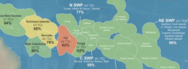
Image credit: Magee, et al.
Tropical cyclones in the Pacific can now be forecast up to four months ahead of the season with a new model developed by scientists from New Zealand and Australia.
According to Dr. Andrew Magee from the center for water, climate, and land at the University of Newcastle, Australia, the model looks at interactions between atmospheres and oceans.
"The provision of accurate and timely seasonal tropical cyclone outlooks is essential for informed decision making, and if we can just make small incremental steps in reducing disaster risk and informing the population of the risks associated with the coming cyclone season, then it has the potential to save lives."
"Our tailored and bespoke tropical cyclone guidance for Pacific Island nations and territories will improve early warnings and support preparations ahead of the tropical cyclone season."
Magee noted that tropical cyclones are responsible for 76 percent of disasters across the Southwest Pacific.


Image credit: Magee, et al.
"Rising sea levels and changes to tropical cyclone related exposure and vulnerability will amplify future tropical cyclone related impacts for Pacific Island nations and territories."
"Our new outlook plays an important role in building a more resilient future for Pacific Island communities," he continued.
While the model will not replace predictions from local meteorological services, Magee said it will allow government and aid agencies to prepare ahead of the season.
"Tropical cyclones are major catastrophes and anything we can do to improve our understanding of what the upcoming season will look like is really beneficial."

Reference
"A new island-scale tropical cyclone outlook for southwest Pacific nations and territories" – Magee, A. D. et al. – Scientific Reports – https://doi.org/10.1038/s41598-020-67646-7
Abstract
The southwest Pacific (SWP) region is vulnerable to tropical cyclone (TC) related impacts that adversely affect people, infrastructure, and economies across several nations and territories. Skillful TC outlooks are needed for this region, but the erratic nature of SWP TCs and the complex ocean-atmosphere interactions that influence TC behavior on seasonal timescales presents significant challenges. Here, we present a new TC outlook tool for the SWP using multivariate Poisson regression with indices of multiple climate modes. This approach provides skillful, island-scale TC count outlooks from July (four months ahead of the official TC season start in November). Monthly island-scale TC frequency outlooks are generated between July and December, enabling continuous refinement of predicted TC counts before and during a TC season. The use of this approach in conjunction with other seasonal climate guidance (including dynamical models) has implications for preparations ahead of severe weather events, resilience, and risk reduction.

Published in the last 24 hours
- Male toads abandoned a pond in Italy five days before a deadly 2009 earthquake, while a scientist was counting them Epicenter
- An asteroid was spotted 19 hours before it exploded over Sudan in 2008, and students picked its pieces off the desert Epicenter
- A wave up to 3 m (10 feet) high rose out of Lake Michigan on a sunny June morning in 1954 and swept fishermen off Chicago’s piers, and when a second came 10 days later, warnings had cleared the shore Epicenter
- Just 12 inches of rushing water can carry away most cars, and more than half of US flood drownings happen to people who drive into flood water Epicenter
