
Tropical Storm “Arthur” expected to form near Bahamas — the first of 2020 Atlantic hurricane season
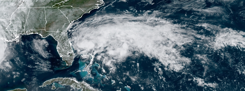
Image credit: NOAA/GOES-East, RAMMB/CIRA. Acquired 17:30 UTC on May 16, 2020.
A storm system is expected to form near the Bahamas this weekend, potentially bringing rain and causing rough seas to parts of the Southeast coast into the following week. Once it becomes a storm, it will be named Arthur — the first of the 2020 Atlantic hurricane season.
A surface low near Southern Florida is being monitored for development as it heads away from the coast, according to the National Weather Service (NWS). It has been producing showers and thunderstorms, along with gusty winds, over portions of South Florida and the northwestern region of the Bahamas.
Florida's Middle Keys already took a hit from the system, with more than 127 mm (5 inches) of rain reported, as well as some street flooding on Thursday, May 14. Wind gusts up to 72 km/h (45 mph) were also recorded in Lower Keys in the same period.
Miami and Fort Lauderdale were drenched on Friday, May 15, with almost 51 mm (2 inches) per hour, triggering a flash flood warning for Miami-Dade county.
This system, tagged "Invest 90L", is a major part of the weather disturbance that the National Hurricane Center (NHC) forecasts to have near 100 percent chance of developing into a tropical or subtropical storm on Saturday, May 17.
**TROPICS WATCH** Here's a recent look of what will likely be our first named storm of the season, which would be #Arthur. You can see on @NOAASatellites GOES-East the better organization of the system as it spins in the Atlantic east of Florida. #tropics pic.twitter.com/xkRbNM94Y3
— WeatherNation (@WeatherNation) May 16, 2020
Updated GFS Ensemble Strike Probability plot for INVEST 90L, likely first named tropical (or subtropical storm) of 2020 Atlantic Hurricane Season by tomorrow. Hurricane Hunter recon flights (TEAL 71 & TEAL 72) have been scheduled if need be.
How I've missed this time of year! pic.twitter.com/z4inmJszIu
— Aaron Perry (@AaronPerryWx) May 15, 2020
Hurricane Hunters are set to examine the system on Saturday to help identify what is going on in the lowest levels of the atmosphere and determine if the system has become a tropical or subtropical depression or storm. It is likely to obtain characteristics of a subtropical or tropical storm this weekend as it moves northeastward.
"Hazardous marine conditions are expected along the Florida east coast and in the Bahamas where Gale Warnings are in effect. Dangerous surf conditions and rip currents are possible along portions of the southeast U.S. coast this weekend and early next week," said NHC.
First mission of the 2020 Atlantic Season, click the link to read more. #ReserveReady #ReadyAF #WeatherReady #WC130J #SuperHercules #WingOfChoice https://t.co/Uzlz0Dlzri pic.twitter.com/d1Q7FZyDYG
— Hurricane Hunters (@53rdWRS) May 16, 2020
The heaviest rains are forecast over the Bahamas through Saturday. The system will eventually have fewer impacts over South Florida even as it intensifies as thunderstorms are predicted on the eastern side of the system, but showers and thunderstorms are likely into the weekend.
A subtropical depression has features of both tropical and non-tropical system, which includes no cold or warm fronts, a wide wind field, and some thunderstorms.
Once the storm develops, it is forecast to move north-northeast, with its center staying off the East Coast, tracking somewhere between Bermuda and North Carolina's outer banks by Monday, May 18.
It may be too early to identify the storm's exact track, but it may track close enough to dump rain and bring gusty winds to the Outer Banks, before turning farther out to the sea.
There is also a small chance that this system will be close enough to the East Coast to dump rainfall from the Carolinas to southeastern New England early next week.
The May 16 12Z GFS model showing average rainfall rate associated with #Invest90L (soon-to-be #Arthur) over the next 54 hours.
Coastal #NorthCarolina would get a heavy rainfall event as the storm skirts the coast (or potentially makes landfall along the Outer Banks).#NCwx #90L pic.twitter.com/z7Qdfvbv6m
— Brenden Mincheff (@BrendenMincheff) May 16, 2020
Commenting rules and guidelines
We value the thoughts and opinions of our readers and welcome healthy discussions on our website. In order to maintain a respectful and positive community, we ask that all commenters follow these rules.