
Tropical cyclone forming in Gulf of Mexico, storm surge and tropical storm watches issued, heavy rainfall expected
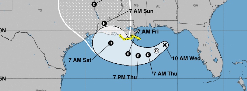
Image credit: NWS/NHC
A tropical cyclone is expected to form by Thursday, July 11, 2019, over the northern Gulf of Mexico, the National Weather Service (NWS) warned at 15:00 UTC on July 10. Storm surge and tropical storm watches have been issued. Heavy rainfall is expected as the system strengthens into an extremely dangerous hurricane.
The center disturbance expected to become Tropical Storm "Barry" was located about 270 km (170 miles) ESE of the mouth of the Mississippi River at 15:00 UTC today (10:00 CDT). The system had maximum sustained winds of 45 km/h (30 mph) and was moving WSW at 13 km/h (8 mph) at the time with minimum central pressure of 1 011 hPa.
A motion toward the WSW or SW is expected through Thursday morning, July 11, followed by a turn toward the west late Thursday (CDT) anda turn toward the WNW on Friday, July 12.
A NW motion is expected by early Saturday, July 13 with an approach to the central U.S. Gulf Coast this weekend.
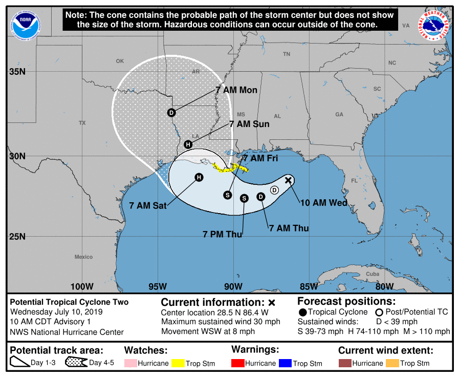
Shower and thunderstorm activity has gradually been increasing in coverage and organization, and the low is likely to become a tropical depression on Thursday morning CDT, a tropical storm by Thursday night, and a hurricane on Friday.
A Storm Surge Watch is in effect for Mouth of the Pearl River to Morgan City.
The combination of a dangerous storm surge and the tide will cause normally dry areas near the coast to be flooded by rising waters moving inland from the shoreline.
The water could reach the following heights above ground somewhere in the indicated areas if the peak surge occurs at the time of high tide:
Mouth of the Pearl River to Morgan City: 90 to 152 cm (3 to 5 feet)
Surge-related flooding depends on the relative timing of the surge and the tidal cycle, and can vary greatly over short distances.
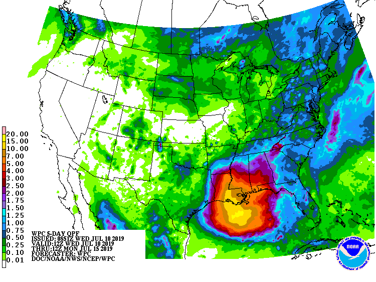
The system is expected to produce total rain accumulations of 152 – 304 mm (6 to 12 inches) near and inland of the central Gulf Coast through early next week, with isolated maximum rainfall amounts of 458 mm (18 inches).
A Tropical Storm Watch is in effect for Mouth of the Mississippi River to Morgan City
Tropical storm conditions are possible within the watch area by late Thursday or early Friday.
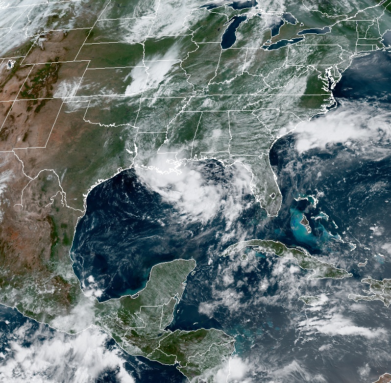
Image credit: NOAA/GOES-East. Acquired 16:20 UTC, July 10, 2019
"The remarkable thing to me as a meteorologist is that several days ago computer models sniffed out that a low pressure-related "spin" in the atmosphere called a Mesoscale Convective Vortex (MCV) was going to move from the U.S. mainland into the Gulf of Mexico and seed a tropical system," Dr. Marhall Shepherd,Atmospheric Sciences Professor and former AMS Prez/NASA scientist, noted.
"I first wrote about this possibility in Forbes last weekend. If this happens, our current generation of weather models deserve "kudos." As National Hurricane Center meteorologist Eric Blake told me in a previous blog, "it will be true model triumph" if this evolves the way it is trending.
Key messages
Potential Tropical Cyclone Two Discussion Number 1
NWS National Hurricane Center Miami FL – AL022019 – Released 15:00 UTC, July 10, 2019
1. A tropical depression is expected to form later today or Thursday. Conditions appear favorable for this system to strengthen to a hurricane at it approaches the central Gulf Coast by the weekend.
2. Dangerous storm surge is possible in portions of southeast Louisiana, and a Storm Surge Watch has been issued for this area. The risk for dangerous storm surge impacts also exists farther west along the Louisiana coast into the Upper Texas coast, and additional storm surge watches may be needed later today or tonight. Residents in these areas should monitor the progress of this system and listen to any advice given by local officials.
3. A Tropical Storm Watch has been issued for portions of the Louisiana coast and additional Tropical Storm or Hurricane Watches could be needed later today or tonight for the remainder of the Louisiana coast and the Upper Texas Coast.
4. The system has the potential to produce very heavy rainfall along and inland of the central Gulf Coast through early next week.
I'm a dedicated researcher, journalist, and editor at The Watchers. With over 20 years of experience in the media industry, I specialize in hard science news, focusing on extreme weather, seismic and volcanic activity, space weather, and astronomy, including near-Earth objects and planetary defense strategies. You can reach me at teo /at/ watchers.news.
Commenting rules and guidelines
We value the thoughts and opinions of our readers and welcome healthy discussions on our website. In order to maintain a respectful and positive community, we ask that all commenters follow these rules.