
Nearly 100 000 without power as severe thunderstorms hit Chicago, Illinois
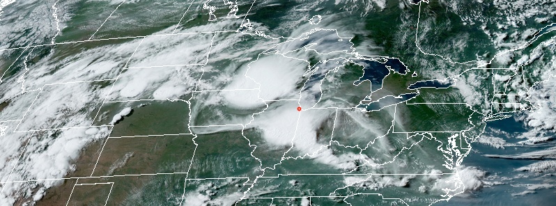
Image credit: NOAA/GOES-East. Acquired: 22:50 UTC on June 30, 2019.
A part of a line of severe thunderstorms swept over Chicago, Illinois metropolitan area on Sunday, June 30, 2019, causing damage throughout the city and leaving nearly 100 000 customers without power.
Winds as high as 119 km/h (74 mph) hit northern Illinois Sunday afternoon (CDT), leaving nearly 100 000 customers across the state without power. Chicago area recorded wind gusts over 96 km/h (60 mph), with 101 km/h (63 mph) at Rockford airport.
Power company ComEd said they sent over 200 crews to restore electricity. As of 05:56 UTC on July 1 (00:56 CDT), 44 626 customers are still without power.
The storms caused damage throughout the city and halted racing at Chicagoland Speedway. Three preliminary tornado reports came in around 16:30 CDT – one near Platte Creek and others in Gregory County.
More than 300 000 customers were without power across the eastern U.S. by Sunday afternoon.
— Hallie Hallock (@HallieHallock) June 30, 2019
Observed a large #gustnado southeast of Chicagoland Speedway. Time: 2:29 PM. @NWSChicago #ILwx #StormHour pic.twitter.com/D3aSyscCdU
— Joey M. Marino (@WxJmar93) June 30, 2019
Storm cluster continues to move SE through area. Increasing coverage ahead of the main cluster is expected. Isolated t-storms with very strong winds, frequent lightning, and heavy downpours will continue to develop through early evening. Have a PLAN ready to seek shelter. pic.twitter.com/mkNXCSUvUk
— NWS Chicago (@NWSChicago) June 30, 2019
A second thunderstorm complex is approaching northwest IL. Arrival of these storms is expected during the 7-9 PM time frame in the outlined area. Frequent lightning and gusty winds are the primary threats. #ilwx #iawx pic.twitter.com/CX46Ta0QEf
— NWS Chicago (@NWSChicago) June 30, 2019
An additional round of thunderstorms is likely through 9 PM this evening. Storms could be severe along and W of I-39, posing a risk of damaging winds and a tornado or two. Additional showers and storms are possible towards the Chicago Metro, but severe weather chances are low. pic.twitter.com/bhXA7Johvu
— NWS Chicago (@NWSChicago) June 30, 2019
"The storms were part of what’s known as a Mesoscale Convective System, or an MCS for short. This is a group of thunderstorms that moves together, often producing damaging winds and occasional tornadoes. These are fairly typical during the late spring and summer," Meteorologist Chris Bianchi noted.
"More storms are possible in the Chicago area over the next few days, but they shouldn’t be quite as strong as Sunday’s."
I'm a dedicated researcher, journalist, and editor at The Watchers. With over 20 years of experience in the media industry, I specialize in hard science news, focusing on extreme weather, seismic and volcanic activity, space weather, and astronomy, including near-Earth objects and planetary defense strategies. You can reach me at teo /at/ watchers.news.
Commenting rules and guidelines
We value the thoughts and opinions of our readers and welcome healthy discussions on our website. In order to maintain a respectful and positive community, we ask that all commenters follow these rules.