
Strong tornadoes, giant hail threaten Iowa to southern Great Lakes as severe storms redevelop
An Enhanced Risk of severe thunderstorms is in place from eastern Iowa into southern Wisconsin, northern Illinois, and the southern Great Lakes region on Tuesday, April 14, 2026, with large to giant hail, several tornadoes, some of which could be strong, and severe wind gusts possible from late afternoon through overnight. The threat follows an April 13 outbreak that produced at least 14 preliminary tornado reports across Kansas, Minnesota, Iowa, and Wisconsin, increasing concern over repeated impacts in parts of the Midwest.
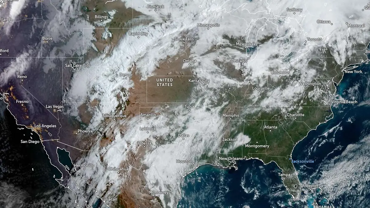
Satellite image of USA acquired at 14:00 UTC on April 14, 2026. Credit: NOAA/GOES, Zoom Earth, The Watchers
An Enhanced Risk of severe thunderstorms is in place from eastern Iowa into southern Wisconsin, northern Illinois, and the southern Great Lakes region on Tuesday, April 14, as forecasters warn that large to giant hail, several tornadoes (some potentially strong), and severe wind gusts are possible from late afternoon through overnight.
The highest threat is expected near a stalled boundary forecast to extend from eastern Iowa into southern Wisconsin by late afternoon, where low-level wind shear and instability are expected to overlap.
The Storm Prediction Center (SPC) said severe thunderstorms are expected from the southern Plains into the Midwest today, with the most favorable environment for intense supercells focused across Iowa into the southern Great Lakes region.
Forecasters expect moisture advection beneath steep mid-level lapse rates to support mixed-layer CAPE at or above 2 500 J/kg across parts of Iowa into the Iowa–Wisconsin–Illinois border region by mid to late afternoon. Initial storms are expected to rapidly organize into supercells capable of all severe hazards, including large to giant hail and tornadoes.
The tornado threat may be highest near the frontal boundary, where locally enhanced storm-relative helicity could support stronger rotating storms. According to the SPC, an intense tornado is possible with the most mature supercells.
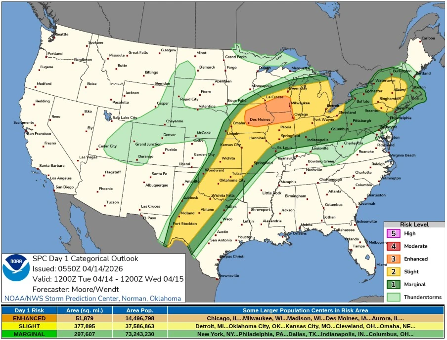
During the evening, storms are expected to grow upscale into a severe cluster aided by a strengthening low-level jet, expanding the damaging wind threat eastward toward the southern Great Lakes overnight. A tornado risk may persist into the evening if storms develop ahead of the main line as the boundary layer recovers.
Farther south, scattered severe thunderstorms are also expected from eastern Kansas into Oklahoma and western north Texas later today into tonight. A very unstable air mass with 2 500–3 000 J/kg MLCAPE and favorable wind profiles may support supercells capable of large to giant hail, while a tornado risk may develop during the early evening depending on low-level shear evolution.
The April 14 threat follows an April 13 severe weather outbreak that produced at least 14 tornado reports across Kansas, Minnesota, Iowa, and Wisconsin.
The most serious preliminary damage was reported near Ottawa, Kansas, where structural damage, snapped power poles, and power outages were reported. No fatalities had been confirmed as of early April 14, while storm surveys remained underway.
Yesterday’s outbreak marked the opening phase of the broader multi-day severe weather pattern now affecting the central United States.
The Weather Prediction Center (WPC) warned repeated rounds of severe thunderstorms and heavy rain are expected across the southern and central Plains, Upper Midwest, and Great Lakes through Thursday, April 16.
Multiple low-pressure waves tracking along a frontal boundary may support daily storm redevelopment, especially during the afternoon and evening, increasing the risk of localized flash flooding in areas affected by repeated rainfall.
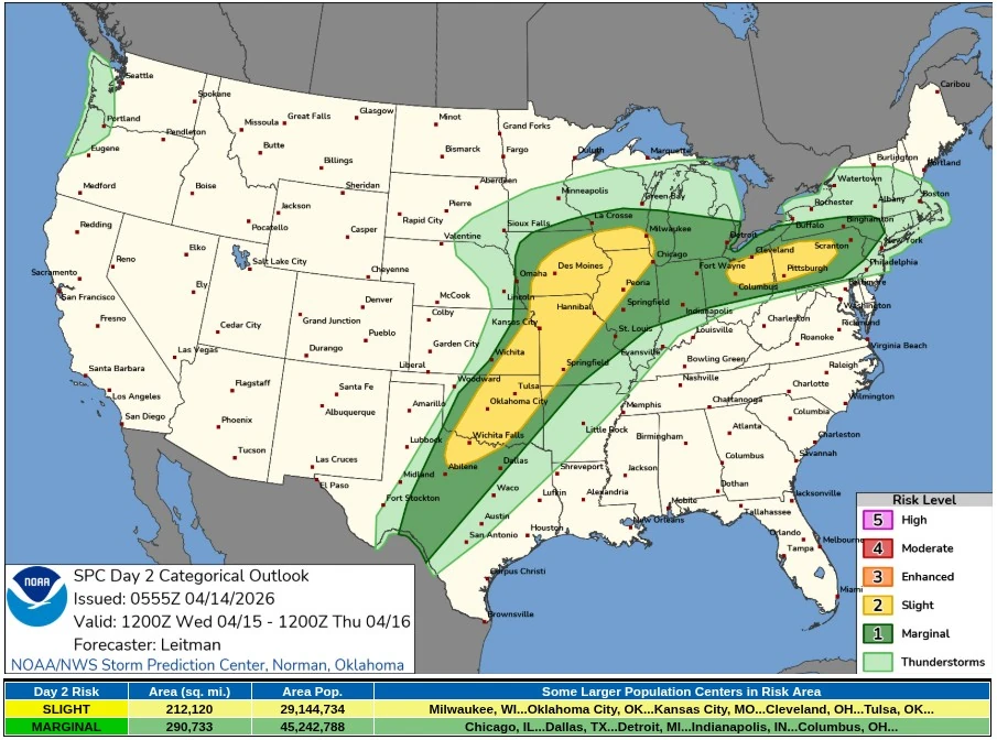
On Wednesday, April 15, renewed severe thunderstorm development is forecast from the southern Plains into the Midwest and southern Great Lakes.
The SPC warned that hail, damaging wind gusts, and a couple of tornadoes will again be possible, with another round of storms likely from eastern Iowa into southern Wisconsin and northern Illinois during the afternoon and evening.
References:
1 Day 1 Convective Outlook – NWS/SPC – April 14, 2026
2 Day 2 Convective Outlook – SPC/NWS – April 14, 2026
3 Short Range Forecast Discussion – NWS/WPC – April 14, 2026
I'm a dedicated researcher, journalist, and editor at The Watchers. With over 20 years of experience in the media industry, I specialize in hard science news, focusing on extreme weather, seismic and volcanic activity, space weather, and astronomy, including near-Earth objects and planetary defense strategies. You can reach me at teo /at/ watchers.news.
Commenting rules and guidelines
We value the thoughts and opinions of our readers and welcome healthy discussions on our website. In order to maintain a respectful and positive community, we ask that all commenters follow these rules.