
Cheboygan Dam nears overtopping as spring flooding worsens across northern Michigan
Cheboygan Dam in northern Michigan rose to within 20 cm (8 inches) of overtopping by early April 14, 2026, despite emergency pumping, gate removals, and efforts to restore a shuttered hydroelectric station to increase discharge. The National Weather Service said Flood Watches remained in effect across much of northern Michigan and the Upper Peninsula as heavy rain, melting snow, and saturated ground continued to drive runoff into rivers, streams, and low-lying areas.
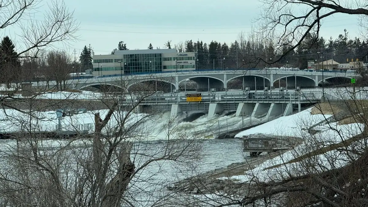
Cheboygan Dam on April 8, 2026. Credit: Michigan DNR
Michigan Gov. Gretchen Whitmer declared a state of emergency on April 10 at the Cheboygan Lock and Dam Complex after rising water levels raised concerns about overtopping and downstream flooding. By Monday, April 13, water behind the dam had risen 15 cm (6 inches) in one day despite five large pumps already operating and crews using cranes to remove dam gates to improve flow.
The Michigan Department of Natural Resources said more pumps were being added and crews were working with utility teams to restore a hydroelectric station that has been offline since 2023. Officials said temporarily returning the plant to service could increase water flow through the complex by about 30 percent, helping stabilize or reduce water levels upstream.
The Cheboygan County Sheriff’s Office urged residents living between the dam and Lake Huron to prepare go-bags, monitor official updates, and be ready to act if conditions worsen.
“This is a prolonged flooding event in the affected areas,” meteorologists at the NWS Gaylord said.
“Be prepared for impacts from high water to last through the week, and potentially longer. Ice on area lakes will slow the flow of water and may prolong the timeframe of this event. Please report observed flooding to local emergency services or law enforcement and request they pass this information to the National Weather Service when you can do so safely.”
Flood Warning for the areas in Emmet and Cheboygan counties within the Cheboygan River basin, upstream of the Cheboygan Dam, is in effect through at least 18:30 EDT on Sunday, April 19, or when waters recede. This includes the Maple River, Crooked Lake, Crooked River, Burt Lake, Indian River, Mullet Lake, Black Lake, the Black River, and the Sturgeon River.
Flood concerns were also increasing elsewhere in northern Michigan. Water at Bellaire Dam was reported to be about 46 cm (18 inches) below overtopping after rising 15 cm (6 inches) overnight, prompting sandbagging operations. Authorities there advised nearby residents to prepare in case evacuations became necessary.
Flood Warnings remained active along the Cheboygan River basin, the Au Sable River near Mio and downstream areas, and the Manistee River, where high releases from Mio Dam and Tippy Dam were adding to elevated flows.
Flooding and storm-related impacts were already affecting transportation and infrastructure. A washout was reported on M-119 Tunnel of Trees after a culvert failure, and flights were canceled at Pellston Regional Airport because of water on the runway.
“Due to the continued flow of water onto the airfield, both runways and infield runway safety areas now have standing water covering a larger amount of surface area than yesterday’s post showed,” Pellston airport officials said April 13.
“The airport has now closed both runways but will remain open for rotary wing traffic (helicopters) if needed. The airlines have been working hard to assist affected passengers with their travel plans, and we continue to monitor the situation as we see more and more areas affected by this year’s thaw. Again, we apologize to all of those in our community who have been or will be impacted by our closure, but safe aircraft operations in and out of Pellston will always be our top priority.”
In Michigan’s Upper Peninsula, officials were also monitoring rising water along the Sturgeon River in Houghton County. Emergency managers said some areas still had 38-76 cm (15-30 inches) of snow on the ground, adding meltwater to already elevated runoff.
A stalled frontal boundary over the Great Lakes was forecast to bring repeated rounds of rain and thunderstorms through at least midweek. Forecast rainfall totals of 25-75 mm (1-3 inches), with locally higher amounts, could worsen river flooding and lowland inundation across already saturated basins.
Northern Michigan and the Upper Peninsula are especially vulnerable to spring flooding in April because rainfall falling on melting snowpack and saturated or partially frozen ground can rapidly increase runoff into rivers and low-lying areas. The current event combines all of those factors, increasing the risk of further rises in water levels this week.
References:
1 Michigan flood watch: Water less than 8 inches from top of Cheboygan Dam – Bridge Michigan/AP – April 14, 2026
2 Crews work through the night to increase water flow through Cheboygan Lock and Dam Complex – Michigan Department of Natural Resources – April 14, 2026
3 Upper Great Lakes flood information – NWS/NOAA National Water Center – April 14, 2026
I'm a dedicated researcher, journalist, and editor at The Watchers. With over 20 years of experience in the media industry, I specialize in hard science news, focusing on extreme weather, seismic and volcanic activity, space weather, and astronomy, including near-Earth objects and planetary defense strategies. You can reach me at teo /at/ watchers.news.
The Detroit News has an update and seems like a telling expose. Good find, thank you.