
Record-breaking May winds over northern France

Image credit: EUMETSAT, Meteo France
A severe weather system moved over northern France on Wednesday, May 8 into Thursday, May 9, 2019, bringing record-breaking May winds to part of the affected region. The system moved in from the Atlantic Ocean, where it underwent rapid cyclogenesis at the beginning of the week.
According to Meteo France, Belle-Ille recorded wind gust of 139 km/h (86 mph), Pointe de Chémoulin recorded 127 km/h (79 mph), Ile de Ré 126 km/h (78 mph) and St-Nazaire 106 km/h (66 mph).
These are records for the month of May, Meteo France meteorologists said.
Un #coupdevent notable pour la saison est prévu ce mercredi #8mai en soirée et première partie de nuit suivante : rafales de vent à 110 km/h sur la côte #atlantique.
Soyez prudents et restez informés https://t.co/pEM2Gra79A pic.twitter.com/s7YADe93S6— VigiMétéoFrance (@VigiMeteoFrance) May 7, 2019
#MeteoDeDemain Pluies fréquentes, averses parfois orageuses sur la plupart des régions sauf en Corse. Coup de vent en soirée et première partie de nuit sur la côte atlantique avec des rafales de vent à 110 km/h. https://t.co/oAkxOPa1eb pic.twitter.com/oFJpF2kzsH
— Météo-France (@meteofrance) May 7, 2019
The system underwent rapid cyclogenesis (bomb cyclone) from Monday, May 6 into Tuesday, May 7 over the open Atlantic Ocean between the Azores and western Europe.
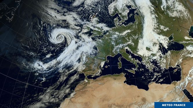
Image acquired May 7, 2019. Credit: EUMETSAT, Meteo France
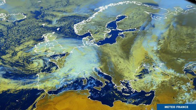
Image acquired May 8, 2019. Credit: EUMETSAT, Meteo France
I'm a dedicated researcher, journalist, and editor at The Watchers. With over 20 years of experience in the media industry, I specialize in hard science news, focusing on extreme weather, seismic and volcanic activity, space weather, and astronomy, including near-Earth objects and planetary defense strategies. You can reach me at teo /at/ watchers.news.
Commenting rules and guidelines
We value the thoughts and opinions of our readers and welcome healthy discussions on our website. In order to maintain a respectful and positive community, we ask that all commenters follow these rules.