
Major flooding in Queensland: Townsville dam spillway gates fully open as extreme rainfall continues, Australia
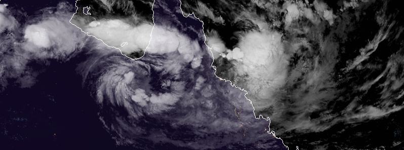
Image credit: JMA/Himawari-8. Acquired 17:40 UTC, February 3, 2019
A vigorous, slow-moving monsoon trough over northern Queensland, Australia is extending from Townsville to Gregory Springs into a deep, semi-stationary tropical low, located about 200 km (124 miles) north of Mount Isa. It will remain active this week, with further heavy and intense rainfall expected for already saturated catchments. Exceptional and record-breaking rainfall has already flooded the region and the potential for significant and dangerous flash flooding will continue for areas between Ingham and Bowen, possibly extending as far south as Mackay from Monday, February 4, 2019.
The region has already received extreme amounts of rain over the past 9 to 10 days, dropping as much as 500 mm (19.6 inches) in 24 hours on January 26 on parts of Douglas Shire. In some places, 300 mm (11.8 inches) of rain fell in just 6 hours. In 48 hours to January 27, the area received more than 620 mm (24.4 inches).
All that rain in such a short period of time caused the Daintree River to rapidly rise, break the major flood stage of 9 m (29.5 feet) around 18:00 LT, January 26 and peak just after 00:00 AEDT on Sunday, January 27 at 12.6 m (41.3 feet), breaking the previous record of 12.4 m (40.6 feet) set in 1901.
The rain continued over the next couple of days and further intensified over Ingham and Townsville, dropping over 500 mm (19.6 inches) of rain in a 24-hour period to 09:00 LT, February 3.
"Most of that fell after sunset, with rates of more than 100 mm (3.93 inches) per hour recorded in Ingham and surrounds," Higgins Storm Chasing reports. "The continuous rainfall over Greater Townsville has also lead to the City recording its wettest week in history – beating the Night of Noah by over 100 mm!"
In January 1998, when the ‘Night of Noah’ occurred, Townsville recorded 913.2 mm (35.9 inches) in a 7-day period which including the Night of Noah itself (548.8 mm / 21.6 inches overnight). The Townsville Airport recorded 886.2 mm (34.8 inches) during that 7-day period as well – this is believed to be the wettest 7-day period for Townsville since records began in the area, Higgins explained, adding:
"The current 7-day period has recorded 1 012 mm (39.8 inches) which has clearly beaten this milestone quite comfortably!"
.@MarlinaWhop with the latest on the flooding emergency in North Queensland. Townsville Airport has just cancelled all flights. #qldweather #7News pic.twitter.com/QaDAnqeojE
— 7 News Townsville (@7NewsTownsville) February 3, 2019
Townsville Mayor @crjennyhill: All we can do now is make sure we’ve got everyone working together … Our main aim now is to protect human lives.
MORE: https://t.co/qHKu8mECZL #pmlive pic.twitter.com/hHi4ZyJk8T
— Sky News Australia (@SkyNewsAust) February 3, 2019
Police and @DeptDefence soldiers working together to help residents who want to relocate before more water comes. #teamwork #bigwet pic.twitter.com/o7nsXuJnEn
— Queensland Police (@QldPolice) February 3, 2019
At 07:10 UTC (18:10 EST) on February 3, BOM's office in Queensland issued a Major Flood Warning for Ross River. "Risk to life and property: Dangerous and high velocity flows will occur in the Ross River Sunday night into Monday. Unprecedented areas of flooding will occur in Townsville."
Emergency services have received hundreds of call for assistance as flood waters continue to rise through the night and ADF members have launched boats into the streets of Idalia, in Townsville’s south, searching for any lights on or residents in need of rescue, the Townsville Bulletin reports.
17 000 properties across Townsville are currently without power.
Dangerous & high velocity flows will occur in the #RossRiver tonight & into Monday. Unprecedented areas of flooding will occur in Townsville. Expect access routes to be cut. Conditions will change rapidly & continuously. Listen to emergency services. #IfItsFloodedForgetIt pic.twitter.com/mOEkfhgtl1
— Bureau of Meteorology, Queensland (@BOM_Qld) February 3, 2019
This includes Rosslea, Hermit Park, Railway Estate, Townsville City, Oonoonba, Idalia, Cluden, West End, Rowes Bay, Garbutt, Aitkenvale, Cranbrook, Currajong, Mysterton, Pimlico, Mundingburra, Douglas, Annandale, Kirwan and Thuringowa Central and South Townsville areas.
…
— Townsville Council (@TCC_News) February 3, 2019
Updated Media Release: Rainfall predictions over Ross River Dam upgraded
Residents in flood-affected suburbs are being warned that the Bureau of Meteorology has increased its rainfall prediction over the Ross River Dam catchment overnight and into tomorrow morning.
…
— Townsville Council (@TCC_News) February 3, 2019
BREAKING: The Ross River Dam spillway gates are fully open now. If safe to do so, please move to higher ground immediately. If you require evacuation assistance, contact SES on 132 500. For life-threatening emergencies call 000.@7NewsTownsville@7NewsBrisbane #7News #qldweather pic.twitter.com/opzfDDq4Gk
— Josh Martin (@JWMartin07) February 3, 2019
‼️Please see map of potential inundated properties.‼️
Please share far and wide with your networks.
For more information listen to local radio, phone 1800 738 541 or visit Council’s Emergency Management Dashboard https://t.co/kZHucVFj12 pic.twitter.com/7ngsq5ZgWz
— Townsville Council (@TCC_News) February 3, 2019
Major Flood Warning for the Ross River
Major Flood Warning for the Bohle and Flood Warning for the Black River and Bluewater Creek
Issued at 02:53 EST on Monday, February 4, 2019 (15:23 UTC, February 3)
Flood Warning Number: 42
RISK TO LIFE AND PROPERTY
The Ross River dam spillway gates have now opened to their full setting. This setting will release approximately 1 900 m3 (67 000 ft3) of water per second out of the dam. Dangerous and high velocity flows will occur in the Ross River Sunday night into Monday. Unprecedented areas of flooding will occur in Townsville. Expect access routes to be cut.
Conditions will change rapidly and continuously. Stay informed, look for updates and follow advice of emergency services.

IMPORTANT INFORMATION FROM TOWNSVILLE CITY COUNCIL:
Residents in many suburbs across Townsville are warned that they may experience flooding from rapid rises of the Ross River. This includes Rosslea, Hermit Park, Railway Estate, Townsville City, Oonoonba, Idalia, Cluden, West End, Rowes Bay, Garbutt, Aitkenvale, Cranbrook, Currajong, Mysterton, Pimlico, Mundingburra, Douglas, Annandale, Kirwan and Thuringowa Central and South Townsville areas.
Everyone in the above suburbs should ensure they move away from riverbanks and get to higher ground. Residents still in their homes in these suburbs should move to the highest ground in their dwelling.
A map of potential inundated properties has been released by Townsville City Council. If you require evacuation assistance, contact SES on 132 500. For life-threatening emergencies call 000. For more information listen to local radio, phone 1800 738 541 or visit Councils Emergency Management Dashboard disaster.townsville.qld.gov.au
Ross River:
The Ross River dam spillway gates have now opened to their full setting. This setting will release approximately 1 900 m3 of water per second out of the dam. River levels downstream at Black Weir are rising and just below the moderate flood level (2.50 m / 8.20 feet).
The Ross River at Aplin Weir is currently at 3.26 m (10.69 feet) and steady, with major flooding. The river level at Aplin Weir may reach around 4.00 m (13.12 feet) during Monday, February 4.
Bohle River:
Major flood levels are easing slowly in the Bohle River at Hervey Range Road following renewed river level rises Sunday evening. Major flood levels are rising further downstream on the Bohle River.
No observations are currently available for the Bohle River at Mt Bohle. Based on upstream river levels, the Bohle River at Mt Bohle is expected to be around the major flood level of 7.00 m (22.96 feet) and steady. The Bohle River at Mt Bohle will remain around the major flood level (7.00 m) Monday morning with forecast rainfall.
Black River and Bluewater Creek:
Stream levels along the Black River and Bluewater Creek are easing with both below the minor flood level. Renewed rises similar to those recorded in previous days are possible with further heavy rainfall.
Flood Safety Advice:
Remember: If it's flooded, forget it. For flood emergency assistance contact the SES on 132 500. For life-threatening emergencies, call Triple Zero (000) immediately. Current emergency information is available at www.qld.gov.au/alerts
Latest River Heights:
| Location | Height of River (m/ft) | Tendency | Date/Time of Observation |
|---|---|---|---|
| Lt Bohle R u/s Bohle Junction Alert | 2.44/8.00 | Falling | 02:34 AM MON 04/02/19 |
| Bohle R at Hervey Range Rd Alert | 7.20/23.62 | Falling | 02:24 AM MON 04/02/19 |
| Bohle R at Dalrymple Rd Alert | 10.94/35.89 | Falling | 02:16 AM MON 04/02/19 |
| Black R upstream Bruce Hwy Alert | 2.89/9.48 | Falling | 02:33 AM MON 04/02/19 |
| Bluewater Ck at Bluewater Alert | 5.53/18.14 | Falling | 02:38 AM MON 04/02/19 |
| Ross R at Ross River Dam Alert | 42.97/140.97 | Rising | 12:02 AM MON 04/02/19 |
| Ross R at Black Weir (Riverway) Alert | 2.40/7.87 | Rising | 02:36 AM MON 04/02/19 |
| Ross R at Aplin Weir Alert | 3.26/10.69 | Steady | 02:28 AM MON 04/02/19 |
| Ross R at Rooneys Bridge Alert | 4.40/14.43 | Rising | 01:26 AM MON 04/02/19 |
This advice is also available by dialing 1300 659 219. Warning, rainfall and river information are available at www.bom.gov.au/qld/flood. The latest weather forecast is available at www.bom.gov.au/qld/forecasts.
Severe Weather Warning
A Severe Weather Warning for damaging, locally destructive winds and heavy rainfall has been issued for Herbert and Lower Burdekin, Central Coast and Whitsundays and parts of Gulf Country, North Tropical Coast and Tablelands, Northern Goldfields and Upper Flinders, North West, Central Highlands and Coalfields and Central West Forecast Districts at 01:43 LT, February 4 (14:43 UTC, February 3).
INTENSE RAINFALL WITH SIGNIFICANT FLASH FLOODING BETWEEN INGHAM AND BOWEN, POSSIBLY EXTENDING SOUTH. RISK REMAINS FOR DAMAGING WINDS, POTENTIALLY DESTRUCTIVE IN THUNDERSTORMS.
Weather situation: A vigorous, slow-moving monsoon trough lies across north Queensland. It currently extends from Townsville to Gregory Springs and into a deep, semi-stationary tropical low, situated about 200 km (124 miles) north of Mount Isa.
The monsoon trough may remain slow-moving or drift shift slowly south over the next day or two. It will remain active this week, with further heavy and intense rainfall expected for already saturated catchments. The potential for SIGNIFICANT and DANGEROUS FLASH FLOODING will continue for areas between Ingham and Bowen, possibly extending as far south as Mackay from today.
HERBERT AND LOWER BURDEKIN AND CENTRAL COAST AND WHITSUNDAYS DISTRICTS:
For the remainder of today, further heavy rainfall with six-hourly rainfall totals between 150 mm to 200 mm (5.90 – 7.87 inches) are likely. Concentrated areas of intense rainfall with totals up to 300 mm (11.8 inches) possible, particularly with bands of thunderstorms.
Creek and river catchments are already saturated and will, therefore, respond extremely rapidly to any rainfall. Landslides have been reported with this event and will continue to be possible in vulnerable areas that have experienced significant rainfall.
Damaging wind gusts up to 100 km/h (62 mph) are also possible about the coast and ranges. Locally destructive winds in excess of 125 km/h (78 mph) may occur with thunderstorms, however, this threat is more likely to be confined to coastal areas.
Locations which may be affected include TOWNSVILLE, INGHAM, BOWEN, AYR, PALM ISLAND, GIRU, ROLLINGSTONE, PROSERPINE AND WHITSUNDAY ISLANDS.
A number of major Flood Warnings are current for this region – please refer to http://www.bom.gov.au/qld/warnings/
REMAINING INLAND AREAS:
For the remainder of today, heavy rainfall, which may lead to localised flash flooding, is expected over parts of the northwestern interior (west of Julia Creek) and eastern interior (east of Gregory Springs) of the state. Six-hourly rainfall totals of 70 mm to 120 mm (2.75 – 4.72 inches) are possible.
Damaging wind gusts up to 90 km/h (56 mph) are also possible to the south of the monsoon trough and tropical low.
Locations which may be affected include CHARTERS TOWERS, CLONCURRY, JULIA CREEK, GREGORY SPRINGS, WINTON AND HUGHENDEN.
Flood Warnings are current for this region – please refer to http://www.bom.gov.au/qld/warnings/
Queensland Fire and Emergency Services advises that people should:
* Move your car under cover or away from trees.
* Secure loose outdoor items.
* Seek shelter, preferably indoors and never under trees.
* Beware of fallen trees and powerlines.
* Never drive, walk or ride through flood waters. If it's flooded, forget it.
* Keep clear of creeks and storm drains.
* For emergency assistance contact the SES on 132 500.
Warnings are also available through TV and Radio broadcasts, the Bureau's website at www.bom.gov.au or call 1300 659 219. The Bureau and Queensland Fire and Emergency Services would appreciate warnings being broadcast regularly.
I'm a dedicated researcher, journalist, and editor at The Watchers. With over 20 years of experience in the media industry, I specialize in hard science news, focusing on extreme weather, seismic and volcanic activity, space weather, and astronomy, including near-Earth objects and planetary defense strategies. You can reach me at teo /at/ watchers.news.
Commenting rules and guidelines
We value the thoughts and opinions of our readers and welcome healthy discussions on our website. In order to maintain a respectful and positive community, we ask that all commenters follow these rules.