
Florida braces for Subtropical Storm “Alberto” landfall, widespread heavy rainfall and inland flooding expected
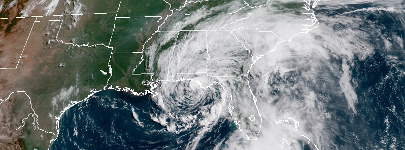
Featured image: Subtropical Storm "Alberto" at 13:45 UTC on May 28, 2018. Credit: NOAA/GOES-East
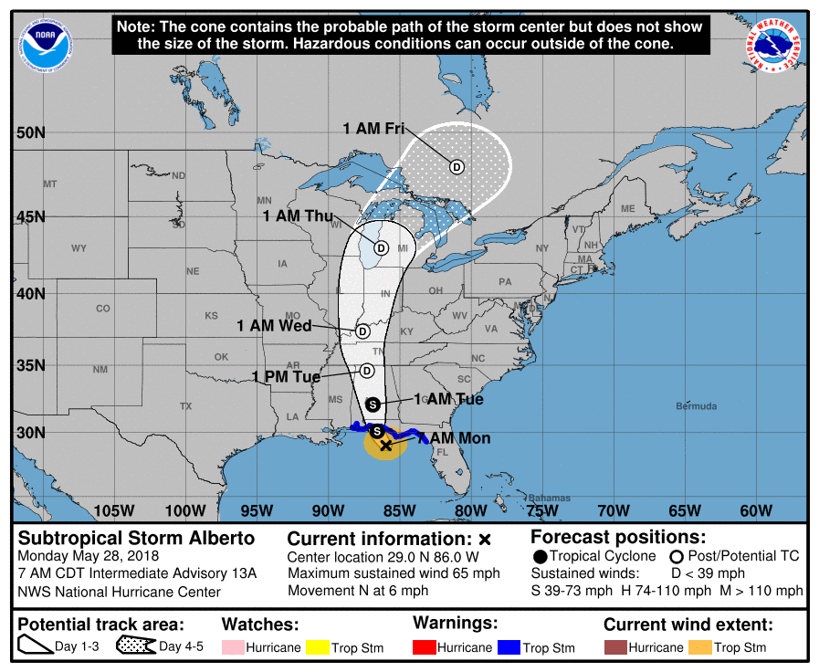
Pre-season Subtropical Storm "Alberto," the first named storm of the 2018 Atlantic hurricane season, is slowly moving toward the U.S. Gulf Coast and is expected to slam into the Florida Panhandle as a strong subtropical storm by the end of Monday, May 28, 2018. After it makes landfall, Alberto is expected to move northward across Alabama and into central Kentucky into Tuesday night, May 29.
This cyclone will pose several threats to the South the first half of this week. Heavy rainfall and inland flooding is expected in the Southeast on Monday, May 28 and shift into the Tennessee and Ohio River Valleys on Tuesday and Wednesday, May 30.
At 12:00 UTC (07:00 CDT), the center of Alberto was located about 165 km (100 miles) SSE of Destin, Florida and was moving N at 9 km/h (6 mph). It had maximum sustained winds of 100 km/h (65 mph) and minimum central pressure of 991 hPa. A faster northward or north-northwestward motion is expected during the next few days. Little change in strength is expected before Alberto reaches the northern Gulf Coast later today.
A Storm Surge Watch is in effect for Suwannee River to Navarre Florida while a Tropical Storm Warning is in effect for Suwannee River to the Mississippi/Alabama border.
On the forecast track, the center of Alberto will cross the northern Gulf Coast in the warning area this afternoon or evening. After landfall, the system is forecast to move well inland into the Tennessee Valley on Tuesday and into the Ohio Valley and Great Lakes region on Wednesday and Thursday, May 30 and 31.
Steady weakening is forecast after landfall, and Alberto will likely become a subtropical depression tonight or early Tuesday and degenerate into a remnant low by Tuesday afternoon.
Alberto is expected to produce the following rain accumulations through Tuesday:
- Central Cuba – additional 127 – 254 mm (5 to 10 inches), isolated storm-totals of 508 – 635 mm (20 to 25 inches).
- The Florida panhandle into much of Alabama and western Georgia – 102 – 204 mm (4 to 8 inches), isolated 305 mm (12 inches).
- The Florida Keys and Florida peninsula – additional 25 – 102 mm (1 to 4 inches), isolated 254 mm (10 inches).
- Rest of the Southeast and Tennessee Valley into the lower mid-Atlantic from Tennessee east through the Carolinas – 51 – 152 mm (2 to 6 inches).
Rains in Cuba could produce life-threatening flash floods and mudslides. Flooding and flash flooding are possible in the southeast United States, including Florida.
The combination of storm surge and the tide will cause normally dry areas near the coast to be flooded by rising waters moving inland from the shoreline. The water could reach the following heights above ground somewhere in the indicated areas if the peak surge occurs at the time of high tide:
- Suwannee River to Navarre Florida: 60 to 120 cm (2 to 4 feet).
The deepest water will occur along the immediate coast. Surge-related flooding depends on the relative timing of the surge and the tidal cycle, and can vary greatly over short distances.
A couple of brief tornadoes are possible today from northern Florida into central and southern Georgia, southern South Carolina, and southeastern Alabama.
Swells generated by Alberto will continue to affect the eastern and northern Gulf Coast through Tuesday. These swells are likely to cause life-threatening surf and rip current conditions.
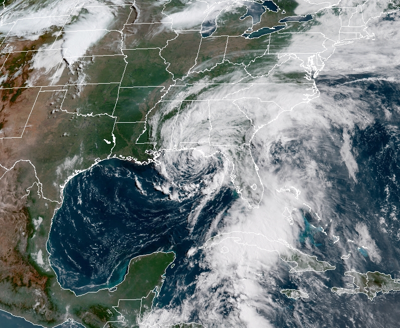
Subtropical Storm "Alberto" at 13:45 UTC on May 28, 2018. Credit: NOAA/GOES-East
As will be the case along the upper Gulf Coast, the saturated ground left in Alberto's wake will make the region susceptible to new flooding problems from any downpours, AccuWeather senior meteorologist Kristina Pydynowski said, adding that any heavy rain would also prevent rivers that become swollen from receding.
The one advantage to the heavy rain is that it can erase the abnormally dry conditions that remained across the upper Gulf Coast, according to the U.S. Drought Monitor's report on Thursday, May 24.
I'm a dedicated researcher, journalist, and editor at The Watchers. With over 20 years of experience in the media industry, I specialize in hard science news, focusing on extreme weather, seismic and volcanic activity, space weather, and astronomy, including near-Earth objects and planetary defense strategies. You can reach me at teo /at/ watchers.news.
Commenting rules and guidelines
We value the thoughts and opinions of our readers and welcome healthy discussions on our website. In order to maintain a respectful and positive community, we ask that all commenters follow these rules.