
Strengthening system to bring heavy rain, snow and strong winds to California
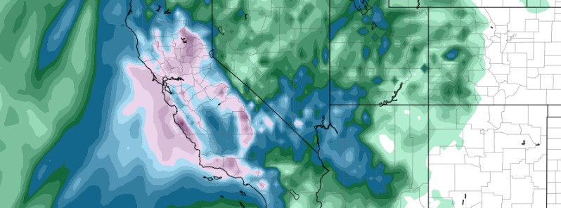
Featured image: Total accumulation model for 06:00 UTC, January 10, 2018. Credit: GFS, TropicalTidbits.com
A strengthening weather system currently located over the open waters of the east-central Pacific is on its way toward the southern and central California coast. It will bring heavy rain, gusty winds and mountain snow to the region through Tuesday, January 9, 2018. This may result in debris flows and mudslides due to recent wildfires, NWS warns.
This system is forecast to be accompanied by a vast plume of moisture emanating from the subtropical Pacific, NWS forecaster Brendon Rubin-Oster noted 08:00 UTC (03:00 EST) today.
Heavy rainfall should spread from north to south as the attendant cold front approaches the coast. Based on the latest forecast, a broad area of 50 – 100 mm (2 to 4 inches) of rain is expected from coastal northern California down toward the Los Angeles basin. Local orographics could easily augment these amounts where favorable upslope flow will increase rainfall rates.
A major issue will be the burn scar areas after a very active fire season to conclude the year 2017. These regions, in particular, will be susceptible to mudslides, debris flows, or other hydrologic issues given the heavy rainfall expected.
Farther inland, the Pacific storm should be more wintry in nature as 305 – 457 mm (12 to 18 inches) of snow is likely over the southern/central Sierra Nevada ranges.
I'm a dedicated researcher, journalist, and editor at The Watchers. With over 20 years of experience in the media industry, I specialize in hard science news, focusing on extreme weather, seismic and volcanic activity, space weather, and astronomy, including near-Earth objects and planetary defense strategies. You can reach me at teo /at/ watchers.news.
Commenting rules and guidelines
We value the thoughts and opinions of our readers and welcome healthy discussions on our website. In order to maintain a respectful and positive community, we ask that all commenters follow these rules.