
Atmospheric river forecast to bring another round of heavy precipitation to California
Atmospheric river associated with a slow-moving low-pressure system is forecast to impact California between February 21 and 26, 2026, bringing another round of heavy precipitation to the state. The Center for Western Weather and Water Extremes (CW3E) indicates very high confidence (>90%) in atmospheric river conditions along northern California through February 23, with moderate-to-high confidence of the AR conditions shifting south along the coast by February 24.

Image credit: NOAA/GOES-West, Zoom Earth, The Watchers. Acquired at 20:50 UTC on February 18, 2026
A surface low strengthening in the Northeast Pacific and a mid-level trough deepening over the Gulf of Alaska are forecast to generate atmospheric river (AR) conditions along the U.S. West Coast beginning Saturday, February 21, 2026.
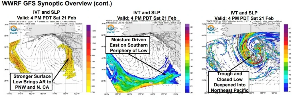
As the low stalls off the Pacific Northwest coast, the AR conditions are forecast to shift southward along the California coast and may tap into lower-latitude moisture along the southern periphery of the trough.
The 00:00 UTC West-WRF ensemble shows very high confidence, exceeding 90%, in AR conditions defined by integrated vapor transport (IVT) of at least 250 kg m⁻¹ s⁻¹ along the Pacific Northwest and northern California coasts between February 21 and 23.
Moderate-to-high probabilities ranging from 60% to 80% support a southward shift of AR conditions along the California coast between February 23 and 24.
Ensemble guidance also indicates low-to-moderate probabilities (30–60%) of short-duration, moderate AR conditions (IVT of at least 500 kg m⁻¹ s⁻¹) associated with initial strengthening on February 22.
Initial landfalling IVT is forecast to be oriented more southerly before becoming west-southwesterly as the IVT corridor propagates down the California coast.
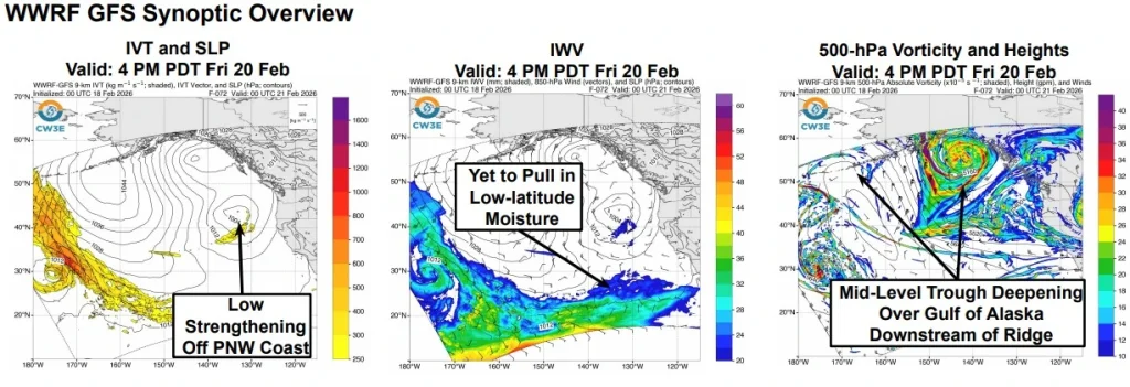
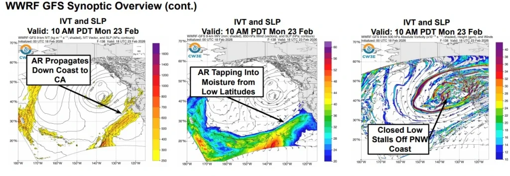
Early in the event, moisture transport within the AR core is expected to be primarily wind-driven, with integrated water vapor values below 20 mm across much of the core. As the trough deepens and stalls offshore, lower-latitude moisture may be transported northeastward along the southern periphery of the system.
The Weather Prediction Center forecasts 127–254 mm (5–10 inches) of precipitation over the northern California Coast Ranges and the Sierra Nevada during the 72-hour period ending 04:00 PT on Wednesday, February 25.
A Marginal Risk Excessive Rainfall Outlook (≥5% probability of flash flooding), has been issued for the northern California Coast Ranges and northern Sierra for the 24-hour period ending 04:00 PT on Monday, February 23.
Freezing level guidance based on GEFS indicates that most precipitation between February 21 and 25 is likely to fall as snow in the Washington Cascades.
In the northern Sierra Nevada, initially high freezing levels are forecast to limit significant snowfall accumulations to the highest elevations before lowering levels allow more widespread snowfall as the storm progresses.
Moderate-to-major winter storm impacts are expected across the Klamath Mountains and the Sierra Nevada. West-WRF ensemble snowfall forecasts for Tuolumne Meadows show high probabilities of at least 122 cm (48 inches) of snowfall through Tuesday, February 24, with approximately 20% of ensemble members indicating totals exceeding 183 cm (72 inches).
Ensemble spread remains significant regarding the onset timing of AR conditions, the magnitude of peak IVT, and the duration of AR impacts for coastal locations in Oregon and northern and central California.
Model-to-model differences between West-WRF configurations initialized with GFS and ECMWF data include variations in the strength and width of the surface low and differences in the speed of AR propagation along the California coast.
The forecast follows an active winter storm currently affecting California, which has brought heavy rain, substantial mountain snowfall, and ongoing hazardous travel and avalanche conditions across parts of the state.
On February 17, an avalanche struck a group of 15 backcountry skiers on slopes near Castle Peak, north of Lake Tahoe. The incident occurred during a powerful winter storm depositing more than 75 cm (30 inches) of new snow across the Sierra Nevada.
Rescue teams from the Nevada County Sheriff’s Office and Placer County Sheriff’s Office, supported by Tahoe Nordic SAR and Truckee Fire, located six survivors after hours of digging through unstable snow. Two rescued skiers were transported to hospital with moderate injuries, while nine remain missing.
References:
1 Potential Coastal Storm and Atmospheric River to Bring Another Round of Heavy Precip to California – CW3E – February 18, 2026
I'm a dedicated researcher, journalist, and editor at The Watchers. With over 20 years of experience in the media industry, I specialize in hard science news, focusing on extreme weather, seismic and volcanic activity, space weather, and astronomy, including near-Earth objects and planetary defense strategies. You can reach me at teo /at/ watchers.news.
Commenting rules and guidelines
We value the thoughts and opinions of our readers and welcome healthy discussions on our website. In order to maintain a respectful and positive community, we ask that all commenters follow these rules.