
Coastal storm and long-duration atmospheric river to bring heavy precipitation to Pacific Northwest and California
A slow-moving low-pressure system is forecast to bring long-duration atmospheric river conditions to the U.S. West Coast between Saturday, February 21, and Wednesday, February 25, 2026, delivering heavy precipitation from Washington to California. The strongest impacts are expected across southern Oregon and northern California Coast Ranges and the Klamath Mountains, where 5–10 inches (125–250 mm) of rain is forecast.

Image credit: NOAA/GOES-West, Zoom Earth, The Watchers. Acquired at 00:10 UTC on February 21, 2026
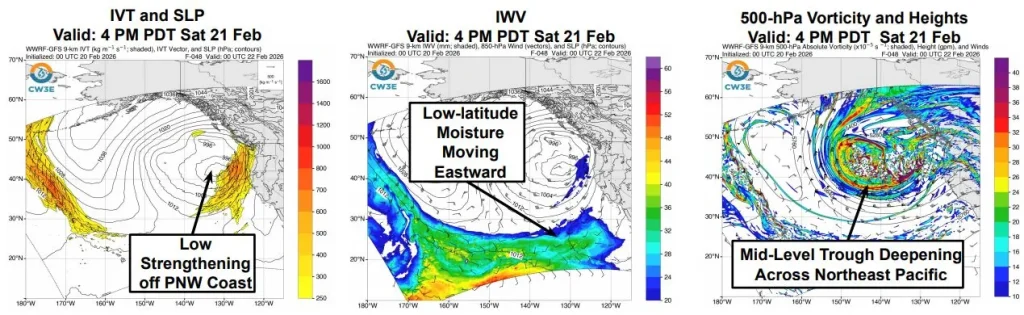
A surface low strengthening off the Pacific Northwest and a deepening mid-level trough from the Gulf of Alaska are forecast to produce long-duration atmospheric river (AR) conditions along the U.S. West Coast through Wednesday, February 25.
According to the outlook issued by the Center for Western Weather and Water Extremes (CW3E) on February 20, this system will produce two distinct pulses of moisture transport as it moves eastward over the northeast Pacific.
The first pulse, expected between Saturday and Sunday, will feature southerly integrated vapor transport (IVT) with wind-driven moisture and relatively low integrated water vapor values below 20 mm within the core of the atmospheric river.
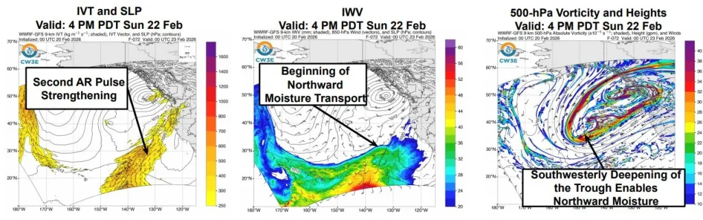
As the system evolves, the mid-level trough will deepen and steer a second, stronger pulse of southwesterly moisture northward toward Oregon and Washington early next week.
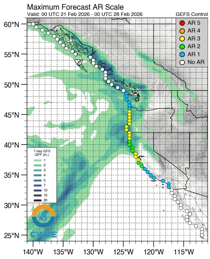
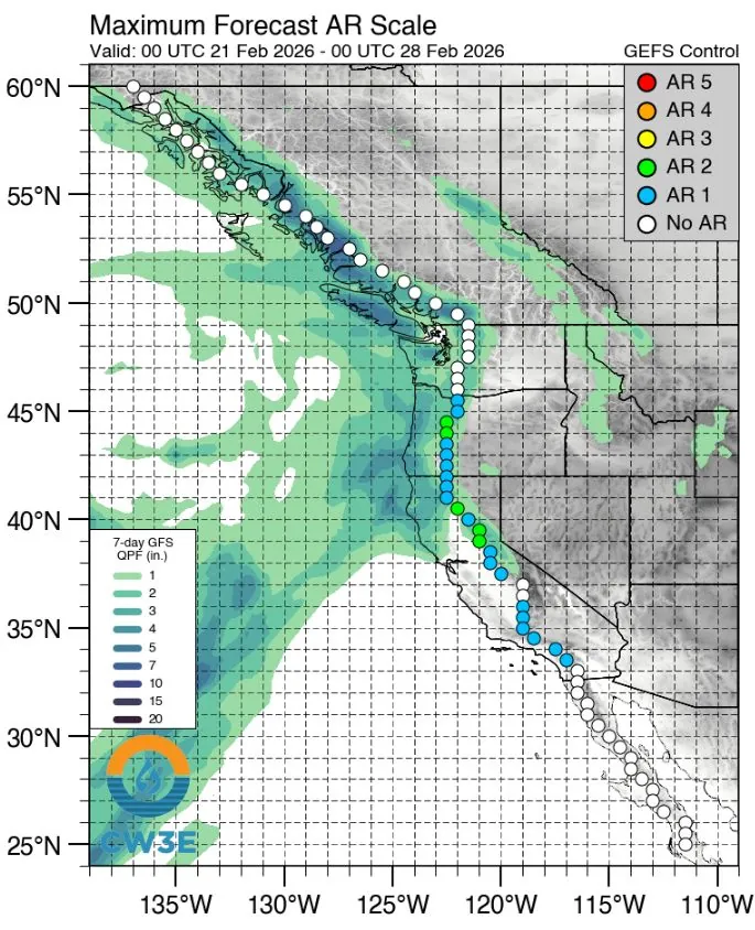
CW3E’s 00 UTC West-WRF ensemble shows very high confidence (>90%) in AR conditions (IVT ≥ 250 kg m⁻¹ s⁻¹) along the Oregon and California coasts through February 25. Moderate probabilities (40–70%) of short-duration moderate AR conditions (IVT ≥ 500 kg m⁻¹ s⁻¹) are also forecast, with ensemble spread remaining in the timing and magnitude of maximum IVT.
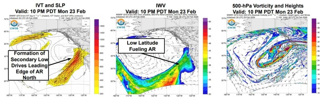
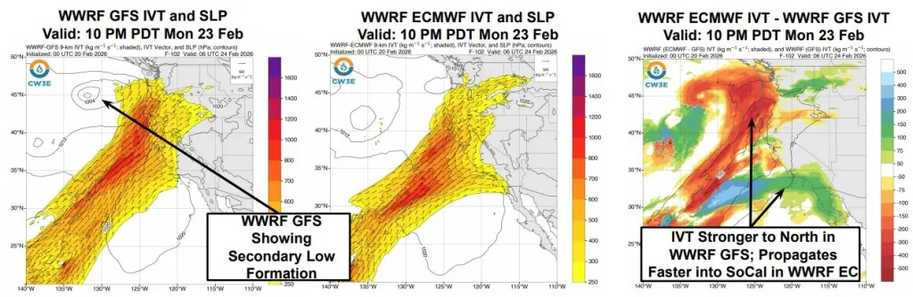
Model-to-model differences persist in the placement of the secondary low and in the extent of the leading edge of the second pulse. The ensemble initialized with the GFS projects stronger IVT into the Pacific Northwest, while the ECMWF-initialized run places the axis farther south toward California.
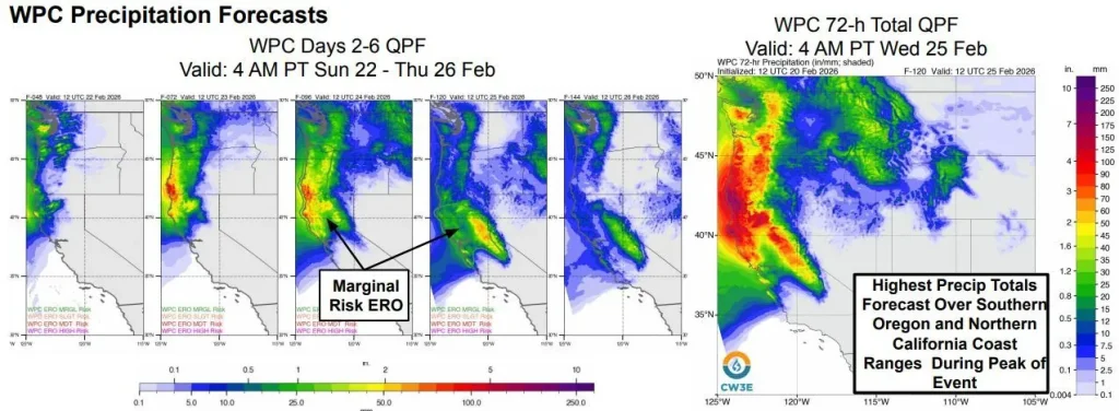
According to CW3E and the Weather Prediction Center, precipitation is forecast to be heaviest over the southern Oregon and northern California Coast Ranges and the Klamath Mountains.
The Weather Prediction Center expects 125–250 mm (5–10 inches) of rain during the 72-hour period ending at 04:00 local time on Wednesday, February 25.
Marginal excessive-rainfall outlooks (≥5% flash-flood probability) have been issued for western Oregon and northern California through Tuesday morning, expanding south into central California and the Sierra Nevada on Wednesday.
Freezing levels across the Sierra Nevada are forecast to remain high, leading to most precipitation falling as rain and increasing runoff potential.
CW3E notes that river and stream rises are likely across western Oregon and northern and central California through Tuesday, February 24. Rain on existing snowpack may accelerate melting and increase hydrologic response in smaller basins.
References:
1 Coastal Storm and Long-Duration Atmospheric River to Bring Precip to Pacific Northwest and California- CW3E – February 20, 2026
I'm a dedicated researcher, journalist, and editor at The Watchers. With over 20 years of experience in the media industry, I specialize in hard science news, focusing on extreme weather, seismic and volcanic activity, space weather, and astronomy, including near-Earth objects and planetary defense strategies. You can reach me at teo /at/ watchers.news.
Commenting rules and guidelines
We value the thoughts and opinions of our readers and welcome healthy discussions on our website. In order to maintain a respectful and positive community, we ask that all commenters follow these rules.