
Alert level raised for Agung volcano, site of one of the largest eruptions of 20th century
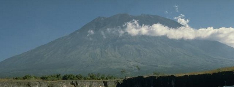
Image credit: Agung volcano towers over the eastern end of the island of Bali. A steep-walled, 200-m-deep crater is located at the summit of the 3142-m-high volcano, seen here from the Sakta River on the eastern flank. Only three eruptions have been recorded in historical time from Gunung Agung; the latest, during 1963-64, produced devastating pyroclastic flows and lahars. Photo by Tom Pierson, 1989 (USGS)
Indonesian authorities have raised the alert level for the Agung volcano in Karangasem district of the province of Bali from 1 to 2 (of 4) on Thursday, September 14, 2017, following an increase in volcanic earthquakes detected on Wednesday, September 13. The last eruption of this volcano occurred in 1963/64.
PVMBG warned residents and tourists to keep away at least 3 km (1.8 miles) from the crater and cautioned against panic, saying there would be further increases in volcanic activity and changes to the alert level before an eruption.
The video below, recorded earlier this month, shows fumaroles at the bottom of the crater. This is normal, according to authorities. However, the seismic swarm recorded since yesterday is not.
This volcano has a history of eruptive activity characterized by explosive and effusive eruptions, pyroclastic and lava flows.
The last eruptive phase of this volcano started on February 18, 1963, with a column as high as 10 km (32 808 feet), and ended on January 27, 1964. It had Volcanic Explosivity Index (VEI) of 5.
This was one of the world's largest eruptions of the 20th century. It produced voluminous ashfall along with devastating pyroclastic flows and lahars that caused extensive damage and some 1 100 fatalities.
Geological summary
Symmetrical Agung stratovolcano, Bali's highest and most sacred mountain, towers over the eastern end of the island. The volcano, whose name means " Paramount," rises above the SE caldera rim of neighboring Batur volcano, and the northern and southern flanks of Agung extend to the coast.
The 3142-m-high (10 308 feet) summit contains a steep-walled, 500-m-wide (1 640 feet), 200-m-deep (656 feet) crater. The flank cone Pawon is located low on the SE side.
Only a few eruptions dating back to the early 19th century have been recorded in historical time. The 1963-64 eruption, one of the world's largest of the 20th century, produced voluminous ashfall along with devastating pyroclastic flows and lahars that caused extensive damage and many fatalities.
I'm a dedicated researcher, journalist, and editor at The Watchers. With over 20 years of experience in the media industry, I specialize in hard science news, focusing on extreme weather, seismic and volcanic activity, space weather, and astronomy, including near-Earth objects and planetary defense strategies. You can reach me at teo /at/ watchers.news.
Commenting rules and guidelines
We value the thoughts and opinions of our readers and welcome healthy discussions on our website. In order to maintain a respectful and positive community, we ask that all commenters follow these rules.