
Super Typhoon “Haima” leaves a trail of destruction in Philippines

Image credit: Typhoon "Haima" impacts the northern Philippines on October 19, 2016. Image copyright: James Reynolds (via Twitter)
Typhoon "Haima," known in the Philippines as Lawin, slammed into Cagayan Province around 19:00 UTC on October 19, 2016 (03:00 PHT on October 20) as a Category 4 hurricane equivalent and trailed over northern Luzon killing at least 13 people and destroying tens of thousands of homes. Haima is the 12th typhoon to hit the Philippines this year and comes just days after deadly Sarika. The yearly average is 20.
The entire province of Cagayan lost power as Haima slammed the island with winds of 225 km/h (140 mph) and gusts up to 315 km/h (195 mph).
Cagayan Governor Manual Mamba told reporters that entire province suffered destruction. "Almost every house here has been damaged," he said.
Two of those killed, aged 16 and 17, died when a landslide hit their house in Ifugao. Two other were buried in a shanty in another mountainous region, the disaster risk council's division in the northern Philippines reported.
Schools and businesses were closed and almost 100 000 of people evacuated before the storm.
Striking 24-hour difference between pre-landfall #Haima & disrupted post-landfall typhoon battering #Luzon via Suomi-NPP #VIIRS. #LawinPH pic.twitter.com/NTbgxC8Nn0
— UW-Madison CIMSS (@UWCIMSS) October 20, 2016
Incredible before & after photos of Tuguegarao taken by my travel partner Mark Thomas – note river, trees, roofs.. #typhoon #Haima #LawinPH pic.twitter.com/cfxNcslX3t
— James Reynolds (@EarthUncutTV) October 20, 2016
Still shot of raging river surrounding Tuguegarao after #typhoon #LawinPH #Haima pic.twitter.com/ByyfSYOFNf
— James Reynolds (@EarthUncutTV) October 20, 2016
At 15:00 UTC on October 20, the center of Typhoon "Haima" was located approximately 448 km (242 miles) SE of Hong Kong, and has tracked NW at 26 km/h (16 mph) over the past 6 hours.
Haima's maximum sustained winds are now 157 km/h (98 mph), which barely makes it a Category 2 hurricane equivalent.
Haima is moving towards its final landfall, expected just east of Hong Kong within the next 18 hours, JTWC said.
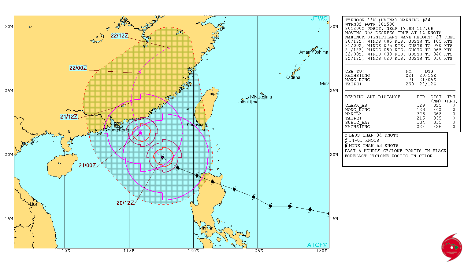
Typhoon "Haima" forecast track by JTWC at 15:00 UTC on October 20, 2016
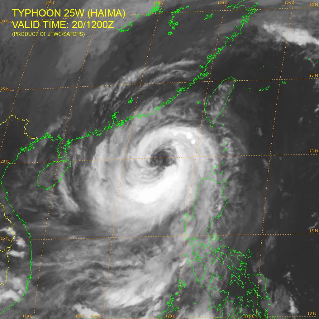
Typhoon "Haima" at 12:00 UTC on October 20, 2016. Credit: JTWC/SATOPS
Haima's outer bands are rotating into Hong Kong, bringing devastating flash floods.
Outer rainbands from #Typhoon #Haima rotating into #HongKong now. Radar via the Hong Kong Observatory. pic.twitter.com/pSH7DHW1eC
— Jonathan Erdman (@wxjerdman) October 20, 2016
The Watchers team and our contributors bring the latest on extreme weather, earthquakes, volcanic eruptions, space weather, and all things science. We're all about making sense of the natural world and keeping you informed on what’s happening. Got a tip or a question? Hit us up using the form at newstips!
Commenting rules and guidelines
We value the thoughts and opinions of our readers and welcome healthy discussions on our website. In order to maintain a respectful and positive community, we ask that all commenters follow these rules.