
Typhoon “Mindulle” about to hit Tokyo with very heavy rain and damaging winds
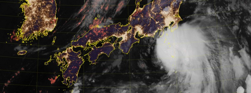
Image credit: JMA/HIMAWARI
Severe Tropical Storm "Mindulle" has reached typhoon strength during the late UTC hours of August 21, 2016. According to the current JMA forecast track, this system is expected to make landfall near Tokyo just after 03:00 UTC on Monday, August 22, 2016. Those living in Mindulle's path are urged to be on the alert for landslides, river flooding, windstorms and high waves.
Mindulle is a very dangerous storm, a heavy rain maker which will bring typhoon strength winds to the Tokyo Metropolitan area.
JMA has issued red and yellow warnings for heavy rain (inundation), floods, high waves, storm surge and thunderstorms across much of the country's east coast. Heavy rain is expected to start during the morning, local time.
Credit: JMA/HIMAWARI
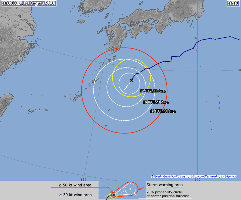
Typhoon "Mindulle" forecast track by JMA at 17:00 UTC on August 21, 2016
The amount of rainfall by Monday evening (JST) is estimated to reach 300 mm (11.8 inches) in the country's eastern regions. 200 mm (7.9 inches) is forecast for the Izu Islands.
Transportation services will be affected. Nearly 180 domestic air flights, mainly to and from Tokyo's Haneda airport on Monday, have already been canceled, NHK said.
JMA officials are urging people to be on the alert for landslides, river flooding, windstorms and high waves.
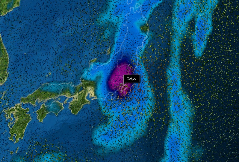
Wind and rain model after landfall on August 22, 2016. Credit: MeteoEarth
As of 18:00 UTC on August 21, Mindulle's center was located about 288 km (178 miles) south of Tokyo.
According to the JMA, its maximum sustained wind speed at the time was 120 km/h (74.8 mph), wind gusts were reaching 176 km/h (109 mph). Mindulle is tracking north at 30 km/h (18.6 mph) with minimum estimated central pressure of 975 hPa.
According to JMA's analysis published 18:50 UTC today, Mindulle's center is expected to be 545 km (339 miles) north of Tokyo, heading NNE at 55 km/h (34 mph) at 18:00 UTC on August 22. At the same time, its maximum sustained wind speed is expected to be 92.6 km/h (57.5 mph).
Mindulle's analysis by Meteorologist Robert Speta of the WestPacWx and NHK
The center of another heavy rain maker, Tropical Storm "Lionrock," was located about 964 km (599 miles) SW of Tokyo and 546 km (339 miles) NNE of Kunigami, Okinawa at 18:00 UTC today.
Lionrock is expected to drift slowly to the west-southwest before stalling near the Ryukyu Islands, dumping heavy rain.
Tropical Storm "Lionrock" forecast track by JMA at 18:00 UTC on August 21, 2016
The Watchers team and our contributors bring the latest on extreme weather, earthquakes, volcanic eruptions, space weather, and all things science. We're all about making sense of the natural world and keeping you informed on what’s happening. Got a tip or a question? Hit us up using the form at newstips!
Commenting rules and guidelines
We value the thoughts and opinions of our readers and welcome healthy discussions on our website. In order to maintain a respectful and positive community, we ask that all commenters follow these rules.