
Douglas and Elida – Two tropical storms developed in the Eastern Pacific

Featured image: GOES-WEST IR satellite image of tropical system developing in Eastern Pacific at 19:30 UTC on June 30, 2014 (Credit: UW-CIMSS/NOAA)
Two tropical low pressure areas chasing each other in the Eastern Pacific over the last several days have now developed into tropical storms. By June 30, 2014, Tropical Storm Douglas and Tropical Storm Elida became more organized but no major development is forecasted.
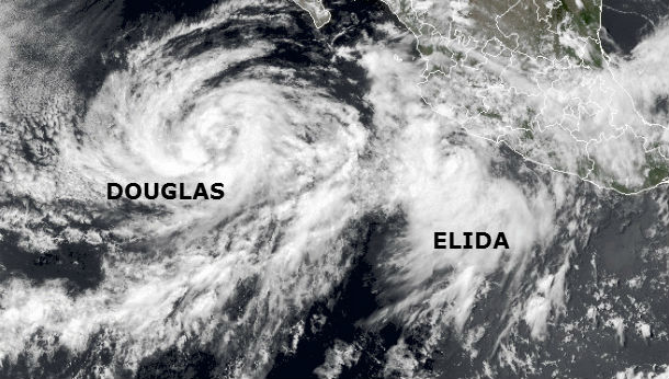
TS Douglas and Elida captured in Eastern Pacific on June 30, 2014 (Credit: NASA/BlueMarble/GOES West)
According to the latest public advisory by NHC, Tropical Storm Douglas is located about 465 miles (750 km) SW of the southern tip of Baja California and is moving NW at speed of 8 mph (13 km/h) with maximum sustained winds of 40 mph (65 km/h). Tropical storm force winds extend outward up to 115 miles (185 km) from the center. Minimum central pressure is 1003 mb (29.62 inches). The system is ingesting drier and more stable air mass as it moves over increasingly cooler waters and slow weakening is expected during the next couple of days. Douglas is expected to become a tropical depression in the next 48 hours.
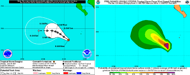
TS Douglas 5-days forecast track and tropical storm force wind speed probabilities maps (Credit: NOAA/NHC)
Tropical Storm Elida is moving west-northwestward parallel to the coast of Mexico. According to the latest public advisory by NHC, Tropical Storm Elida was located about 120 miles (195 km) S of Manzanillo, Mexico and is moving NW at speed of 12 mph (19 km/h) with maximum sustained winds of 50 mph (85 km/h). Tropical-storm-force winds extend outward up to 105 miles (165 km)from the center. Minimum central pressure is 1003 mb (29.62 inches).
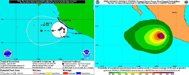
TS Elida 5-days forecast track and tropical storm force wind speed probabilities maps (Credit: NOAA/NHC)
A Tropical Storm Warning is in effect for Lazaro Cardenas to Cabo Corrientes. Swells generated by Elida are affecting portions of the southwestern coast of Mexico and are likely to cause life-threatening surf and rip currents. Tropical storm conditions are affecting portions of the southwestern coast of Mexico and these conditions are expected to expand northwestward during the next day or two. Elida is expected to produce total rain accumulations of 3 to 6 inches over the western portions of the Mexican states of Colima and Michoacan and over the southwest portion of Jalisco.
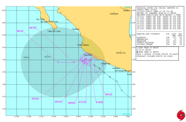
TS Elida forecast track by JTWC
Moderate to strong northwesterly vertical wind shear is expected to affect the cyclone for at least the next 3 days, which should prevent any significant intensification from occurring despite the very warm sea-surface temperatures and moist mid-level environment surrounding the storm.
Satellite Animations
- Storm-Centered Infrared (GOES 15; NOAA/SSD)
- Storm-Centered Infrared (Aviation Color Enhancement) (GOES 15; NOAA/SSD)
- Storm-Centered Water Vapor (GOES 15; NOAA/SSD)
- Storm-Centered Visible (GOES 15; NOAA/SSD)
- Storm-Centered Visible (Colorized) (GOES 15; NOAA/SSD)
- Storm-Centered Infrared (GOES 15; CIMSS)
- Storm-Centered Enhanced Infrared (GOES 15; CIMSS)
- Storm-Centered Water Vapor (GOES 15; CIMSS)
- Storm-Centered Visible (GOES 15; CIMSS)
- Tropical East Pacific Hurricane Sector Infrared (GOES 15; NOAA)
- Tropical East Pacific Hurricane Sector Water Vapor (GOES 15; NOAA)
- Tropical East Pacific Hurricane Sector Visible (GOES 15; NOAA)
Commenting rules and guidelines
We value the thoughts and opinions of our readers and welcome healthy discussions on our website. In order to maintain a respectful and positive community, we ask that all commenters follow these rules.