
Hurricane “Norbert” hits Mexico, forces evacuations
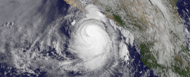
Image credit: NASA/NOAA GOES Project
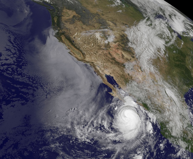
Tropical Storm "Norbert" was formed on September 2 about 180 miles (285 km) southwest of Manzanillo, Mexico's Pacific coast. Around 03:00 UTC on Friday, September 5, Norbert was Category 1 hurricane with maximum sustained winds around 90 mph (145 km/h). It was strengthening and dumping heavy rain along the tourist-friendly coast of the Baja California peninsula.
Carlos Enrique Rincon, the head of civil protection in Baja California Sur state, said more than 1 000 people who live in high-risk areas were taken to temporary shelters.
Cabo San Lucas mayor, Jose Antonio Agundez Montano, said several rural communities lacked power or drinking water on Friday and that authorities were unable to communicate with them.
At 06:00 UTC today, September 6, Hurricane "Norbert" was located approximately 198 nautical miles (227 miles/366 km) northwest of Cabo San Lucas, and was moving northwestward at around 06 knots (6.9 mph/11.1km/h).
Maximum significant wave height at the time was 24 feet (7.31 meters). Norbert's maximum sustained winds were 105 knots (120 mph/194 km/h) making it a Category 3 hurricane. Winds gusts were 130 knots (149 mph/249 km/h).
Gradual weakening is expected.
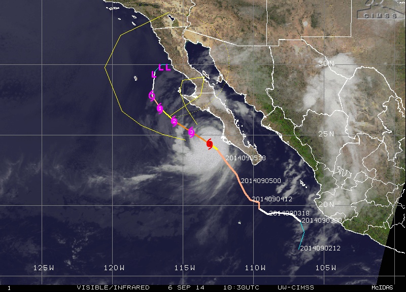
Huricane "Norbert" forecast track by UW-CIMSS on September 6, 2014.
Conagua (Comisión Nacional del Agua / Servicio Meteorológico Nacional – Mexico) issued hurricane warnings for the west coast of Baja California Sur, from Santa Fe to Cabo San Lazaro, including Magdalena Bay; and the tropical storm warning covering La Paz to Loreto on the Gulf of California, and Cabo San Lucas to Santa Fe and Cabo San Lazaro to Punta Eugenia, on the Pacific coast.
"Heavy rain is expected to continue in the coming hours – heavy rains (75 to 150 mm) are expected in Baja California Sur, Nayarit, Sinaloa and Sonora; very strong (50 to 75 mm) in Baja California; strong (25 to 50 mm) in Jalisco and Michoacan and less intense in Colima"
Video courtesy of Servicio Meteorológico Nacional – Mexico
.jpg)
This GOES-West satellite image of Tropical Storm Norbert was taken at 12:00 UTC on September 2 and showed some bands of thunderstorms had formed south of the center of circulation, and around the center. Image credit: NASA/NOAA GOES Project

The MODIS instrument aboard NASA's Terra satellite captured this image of Tropical Storm "Norbert" on September 4 at 18:15 UTC when it resembled a pinwheel. Image credit: NASA Goddard MODIS Rapid Response Team
This visible image of Hurricane Norbert was taken from NOAA's GOES-West satellite at 14:45 UTC on September 5. Image credit: NASA/NOAA GOES Project
I'm a dedicated researcher, journalist, and editor at The Watchers. With over 20 years of experience in the media industry, I specialize in hard science news, focusing on extreme weather, seismic and volcanic activity, space weather, and astronomy, including near-Earth objects and planetary defense strategies. You can reach me at teo /at/ watchers.news.
Commenting rules and guidelines
We value the thoughts and opinions of our readers and welcome healthy discussions on our website. In order to maintain a respectful and positive community, we ask that all commenters follow these rules.