
Tropical Storm Flossie crossing Hawaii Islands
Featured image: GOES West infrared satellite image from 17:00 UTC on July 29, 2013 (Credit: NOAA/GOES)
Tropical Storm Flossie weakens as it approaches Maui County and The Big Island, entering the cooler waters surrounding Hawaii. Satellite loops suggest a rapid weakening trend with the low level center pulling away from the small area of convection southeast of the center. Flossie is expected to weaken steadily as it tracks northwest, and to dissipate within 48 hours.
A tropical storm loses its status if winds are below 39 mph and according to the Central Pacific Hurricane Center (CPHC) in Honolulu, maximum sustained winds are currently 40 mph (65 km/h). Forecasters expect weakening trend as wind shear and interaction with mountainous terrain on Maui and the Big Island impact the system.

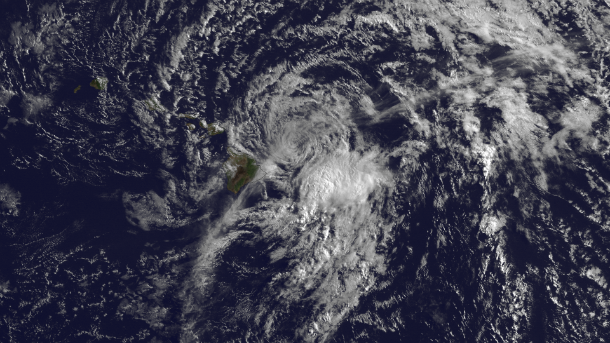
GOES West infrared satellite image from 17:00 UTC on July 29, 2013 (Credit: NOAA/GOES)
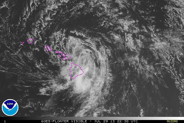
GOES West visible satellite image from 22:30 UTC on July 29, 2013 (Credit: NOAA/GOES)
According to latest public advisory (#20) issued by US National Hurricane Center (NHC), at 21:00 UTC on July 29, 2013, the center of Tropical Storm Flossie was located about 65 miles (100 km) NNE of Hilo and about 200 miles (320 km) ESE of Honolulu, Hawaii. Flossie is moving toward the west-northwest near 18 mph (30 km/h) and this motion is expected to continue for the next 24 to 48 hours. Maximum sustained winds are 40 mph (65 km/h) with higher gusts. Some weakening is forecast during the next 24 hours. The estimated minimum central pressure is 1000Mb (29.53 inches).
.png)
NHC 5-day forecast track and tropical storm force wind speed probabilities map (Credit: NOAA/NHC)
Tropical storm force winds extend outward up to 70 miles (110 km) from the center. A Tropical Storm Warning is in effect for Maui County, including the islands of Maui, Molokai, Lanai and Kahoolawe, Oahu, Kauai and Niihau.
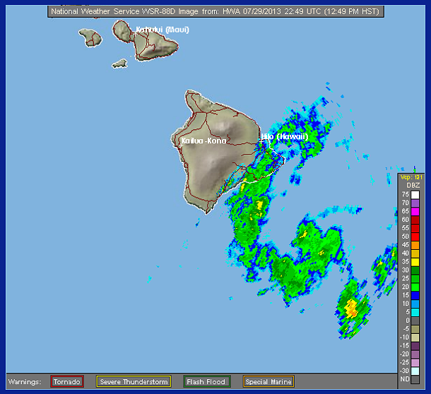
South Shore radar image at 22:49 UTC on July 29, 2013 (Credit: NWS/HWA/WSR)
Heavy rainfall is expected over Hawaii County and over Maui County, with heavy rain spreading to Oahu. Flossie is expected to produce total rainfall amounts of 2 to 4 inches over The Big Island with isolated amounts up to 6 inches. Over the rest of the state total rainfall amounts will be 1 to 2 inches with isolated amounts up to 6 inches. Flossie is also expected to spark rare flashes of lightning and may spawn an isolated waterspout or tornado. This rainfall could cause life-threatening flash floods and mud slides, especially in the mountains.
Dangerously high surf is affecting east facing shores of Maui and The Big Island. Large surf is gradually spreading to the rest of the islands. The large surf may cause coastal road closures. Some beach erosion can occur.
Satellite Animations
- Storm-Centered Infrared (GOES 15; NOAA/SSD)
- Storm-Centered Infrared (Aviation Color Enhancement) (GOES 15; NOAA/SSD)
- Storm-Centered Water Vapor (GOES 15; NOAA/SSD)
- Storm-Centered Visible (GOES 15; NOAA/SSD)
- Storm-Centered Visible (Colorized) (GOES 15; NOAA/SSD)
- Central Pacific Infrared (GOES 15; NOAA)
- Central Pacific Infrared (Aviation Color Enhancement) (GOES 15; NOAA)
- Central Pacific Water Vapor (GOES 15; NOAA)
- Central Pacific Visible (GOES 15; NOAA)
- Central Pacific Visible (Colorized) (GOES 15; NOAA)
Commenting rules and guidelines
We value the thoughts and opinions of our readers and welcome healthy discussions on our website. In order to maintain a respectful and positive community, we ask that all commenters follow these rules.