
Hurricane Iona and Tropical Storm Keli form off the coast of Hawaii
Hurricane Iona and Tropical Storm Keli formed southeast of Hawaii on July 28, 2025, becoming the first two named storm to form in the central Pacific this year. Iona was named in the NHC advisory issued at 03:00 UTC and reached hurricane strength by 15:00 UTC the same day. Keli followed approximately 18 hours later, reaching tropical storm strength by 21:00 UTC. Both systems are moving westward and are not expected to make landfall.

Satellite image of Hurricane Iona and Tropical Storm Keli, acquired at 01:00 UTC on July 29, 2025. Credit: NOAA/GOES-East, RAMMB/CIRA, The Watchers
Hurricane Iona and Tropical Storm Keli formed southeast of Hawaii, rapidly strengthening on July 28. Iona was the first named storm of 2025 to form in the central Pacific, named in the advisory issued by the National Hurricane Center (NHC) at 03:00 UTC on July 28 (17:00 HST on July 27).
Iona intensified rapidly after formation, reaching hurricane strength by 15:00 UTC (05:00 HST) on July 28.
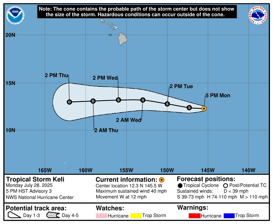
Tropical Storm Keli formed approximately 18 hours after Iona and was named in the advisory issued at 21:00 UTC (11:00 HST) on July 28.

As per the latest advisory issued at 03:00 UTC on July 29 (17:00 HST on July 28), Iona was located approximately 1 440 km (895 miles) southeast of Honolulu, Hawaii. Sustained winds near the center reached 120 km/h (75 mph) with higher gusts. Minimum central pressure was estimated at 994 hPa, with hurricane-force winds extending outward up to 25 km (15 miles).
The hurricane was moving westward at 16 km/h (10 mph) and was forecast to maintain this general motion, becoming a major hurricane on July 29. Based on the NHC forecast track, Iona is not expected to make landfall and is forecast to begin weakening by midweek.
Meanwhile, Tropical Storm Keli was located approximately 1 660 km (1 030 miles) southeast of Honolulu. Sustained winds near the center reached 65 km/h (40 mph) with higher gusts. Minimum central pressure was estimated at 1 008 hPa, with tropical storm-force winds extending outward up to 55 km (35 miles).
Keli was moving westward at 19 km/h (12 mph) and was expected to continue this general motion for the next several days. While some additional strengthening was possible on July 29, Keli is forecast to begin weakening by midweek and is not expected to make landfall.

I am an Assistant Editor and Severe Weather & Science Journalist at The Watchers, specializing in real-time severe weather coverage, geophysical event reporting, and research-driven scientific analysis. You can reach me at rishav(at)watchers(.)news.
Commenting rules and guidelines
We value the thoughts and opinions of our readers and welcome healthy discussions on our website. In order to maintain a respectful and positive community, we ask that all commenters follow these rules.