
Magnitude 6.2 deep earthquake strikes border region of Russia, China and North Korea
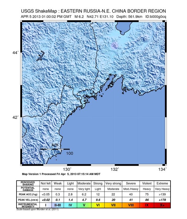
Image credit: USGS Shake Map
Deep earthquake with recorded magnitude of 6.2 struck border region of Russia, China and North Korea on Friday, April 05, 2013 at 13:00 UTC. Epicenter of the earthquake was located 9 km (5 miles) N of Zarubino, Russia and 28 km (17 miles) SW of Slavyanka, Russia at coordinates 42.713°N, 131.105°E. USGS reported epicenter at depth of 561.9 km (349.2 miles) whereas EMSC reported depth 546 km. This data is still preliminary.
GDACS reported this earthquake can have a low humanitarian impact based on the magnitude and the affected population and their vulnerability.
1,400,000 people live within 100 km radius of the earthquake.
| Magnitude | 6.2 |
|---|---|
| Date-Time |
|
| Location | 42.713°N, 131.105°E |
| Depth | 561.9 km (349.2 miles) |
| Region | EASTERN RUSSIA-N.E. CHINA BORDER REGION |
| Distances | 9 km (5 miles) N of Zarubino, Russia 28 km (17 miles) SW of Slavyanka, Russia 62 km (38 miles) ENE of Aoji-ri, North Korea 63 km (39 miles) ESE of Hunchun, China |
| Location Uncertainty | horizontal +/- 14.2 km (8.8 miles); depth +/- 9.2 km (5.7 miles) |
| Parameters | NST=101, Nph=101, Dmin=180.3 km, Rmss=1.03 sec, Gp= 29°, M-type=regional moment magnitude (Mw), Version=9 |
| Source |
|
| Event ID | usb000g0cq |
Shakemap: earthquake intensity. Credits: USGS
Looks like a great aiming point for a few of our ballistic missles don’t it! 1 million,400 thou and just one warhead needed! Mark that one on the pentagon map.3 tirds with one stone!It don’t get no better than that does it!!!