
Very strong M 6.2 earthquake below north coast of Papua New Guinea
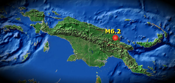
Image credit: TW
M6.2 earthquake struck near north coast of papua New Guinea on August 19 at 22:41 UTC. The epicenter was located 104 km (64 miles) SSE of Angoram and 118 km (73 miles) NNE of Mount Hagen, Papua New Guinea (4.849°S, 144.583°E). The epicenter was at depth of 77.3 km (48.0 miles). Considering the depth and area where earthquake occur, there is no damage reports as well as no injuries.

The epicenter was located only 118 km from Mount Hagen which is the second highest volcano in Papua New Guinea. It is also the area where three plates collide – Woodlark Plate, North and South Bismarck Plate.
The largest recorded earthquake that hit PNG was magnitude 8.0 at New Ireland region on November 16, 2000.
Commenting rules and guidelines
We value the thoughts and opinions of our readers and welcome healthy discussions on our website. In order to maintain a respectful and positive community, we ask that all commenters follow these rules.