
Magnitude 6.3 earthquake hit New Ireland region, PNG
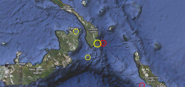
Image credit: TW
Magnitude 6.3 earthquake hit New Ireland, Papua New Guinea on August 2, 2012 at 9:56 UTC according to USGS. Epicenter was located 34 km (21 miles) SE of Taron, PNG at 4.706°S, 153.228°E. Recorded depth was 70.6 km (43.9 miles).
EMSC is reporting magnitude 5.8 and depth of 60 km.
This earthquake can have a low humanitarian impact based on the magnitude and the affected population and their vulnerability. There are no people living in 100 km radius.
| Magnitude | 6.3 |
|---|---|
| Date-Time |
|
| Location | 4.706°S, 153.228°E |
| Depth | 70.6 km (43.9 miles) |
| Region | NEW IRELAND REGION, PAPUA NEW GUINEA |
| Distances | 34 km (21 miles) SE of Taron, PNG 114 km (70 miles) ESE of Kokopo, Papua New Guinea 304 km (188 miles) WNW of Arawa, Papua New Guinea 354 km (219 miles) ENE of Kimbe, Papua New Guinea |
| Location Uncertainty | horizontal +/- 14 km (8.7 miles); depth +/- 9.1 km (5.7 miles) |
| Parameters | NST=245, Nph=256, Dmin=131.4 km, Rmss=0.83 sec, Gp= 18°, M-type=regional moment magnitude (Mw), Version=7 |
| Source |
|
| Event ID | usb000bldc |

I'm a dedicated researcher, journalist, and editor at The Watchers. With over 20 years of experience in the media industry, I specialize in hard science news, focusing on extreme weather, seismic and volcanic activity, space weather, and astronomy, including near-Earth objects and planetary defense strategies. You can reach me at teo /at/ watchers.news.
Commenting rules and guidelines
We value the thoughts and opinions of our readers and welcome healthy discussions on our website. In order to maintain a respectful and positive community, we ask that all commenters follow these rules.