
Very strong and deep 7.0 magnitude earthquake struck Papua New Guinea
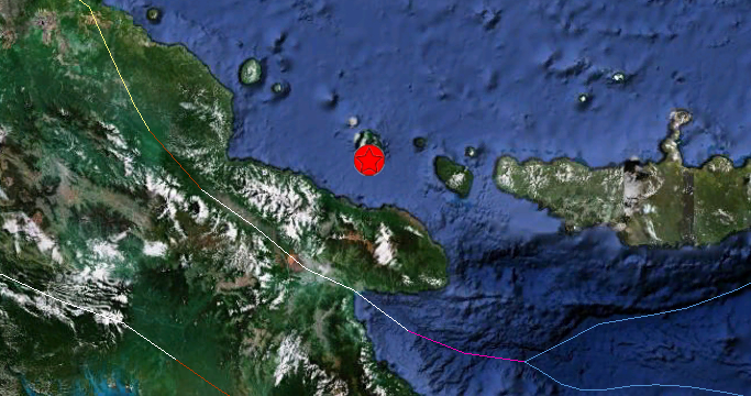
Image credit: Google Earth + USGS
Very strong and deep earthquake with magnitude 7.0 struck Papua New Guinea on April 17, 2012 at 07:13:50 UTC according to USGS. The epicenter was located 141 km (88 miles) N (5°) from Lae, New Guinea, PNG (5.482°S, 147.101°E). Recorded depth at the epicenter was 201.1 km (125.0 miles).
No tsunami warning was issued. All data captured so far are confirming the probably harmless character of this earthquake.
Geofon reports a magnitude of 6.6 at a depth of 199 km. EMSC a Magnitude of 7.1 at a depth of 190 km.
This earthquake would be felt by millions of people in a very wide area because of the depth of the hypocenter.
The epicenter of this earthquake is on the coast of Long Island, an island to the north of Eastern PNG. The epicenter is however of less importance in deep earthquakes as the seismic waves are radiating to the surface from deep within the hot solid earth.
| Magnitude | 7.0 |
|---|---|
| Date-Time |
|
| Location | 5.482°S, 147.101°E |
| Depth | 201.1 km (125.0 miles) |
| Region | EASTERN NEW GUINEA REG, PAPUA NEW GUINEA |
| Distances |
|
| Location Uncertainty | horizontal +/- 12.5 km (7.8 miles); depth +/- 3.1 km (1.9 miles) |
| Parameters | NST=322, Nph=334, Dmin=381.8 km, Rmss=0.82 sec, Gp= 14°, M-type=regional moment magnitude (Mw), Version=9 |
| Source |
|
| Event ID | usc00095c9 |

I'm a dedicated researcher, journalist, and editor at The Watchers. With over 20 years of experience in the media industry, I specialize in hard science news, focusing on extreme weather, seismic and volcanic activity, space weather, and astronomy, including near-Earth objects and planetary defense strategies. You can reach me at teo /at/ watchers.news.
Commenting rules and guidelines
We value the thoughts and opinions of our readers and welcome healthy discussions on our website. In order to maintain a respectful and positive community, we ask that all commenters follow these rules.