
Gobi desert sand and dust storms plague East Asia
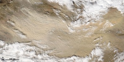
Image credit: TW
Fire and Earth blog brings this satellite photo report of massive sandstorms over Gobi desert spreading all over east Asia and Japan.
This true-color image of North China Plain, Shandong Peninsula and the Bo Haitaken was taken by MODIS on NASA’s Terra satellite as sand from Gobi Desert blew across the region.


For a second time in 12 days, large plumes of sand and dust blew out of the Gobi Desert and spread across the Mongolia-China border. MODIS on NASA’s Terra satellite took this image on May 11, 2011.

Sand and dust storms from the Gobi Desert blew across China covering the Yellow Sea in late April and early May 2011. MODIS on NASA’s Aqua satellite captured this natural-color image on May 1, 2011.

Gobi Desert dust plumes blew eastward in late April 2011. MODIS on NASA’s Aqua satellite acquired this natural-color image on April 29, 2011.

Massive plumes of sand and dust blew out of the Gobi Desert on May 11 moving toward northeastern China, and covering the provinces of Heilongjiang, Jilin, and Liaoning the next day when MODIS on NASA’s Terra satellite took this image. The visibility in the region was reportedly reduced to about 1 000 meters (3 000 feet).

Thick plumes of dust from Gobi Desert covered the Sea of Japan on May 13, 2011, when MODIS on NASA’s Terra satellite took this image.

Commenting rules and guidelines
We value the thoughts and opinions of our readers and welcome healthy discussions on our website. In order to maintain a respectful and positive community, we ask that all commenters follow these rules.