
SPC issues Extremely Critical fire weather outlook for eastern New Mexico and far western Texas Panhandle
The Storm Prediction Center issued an Extremely Critical Fire Weather Area for portions of eastern New Mexico into the far western Texas Panhandle on Sunday, April 26, 2026. Red Flag Warnings cover much of the southern High Plains as southwest winds of 40-55 km/h (25-35 mph), localized gusts of 80-95 km/h (50-60 mph), and very low relative humidity create conditions where any new fire could spread rapidly.
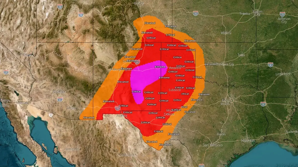
Fire weather outlook map for April 26, 2026. Credit: NWS/SPC
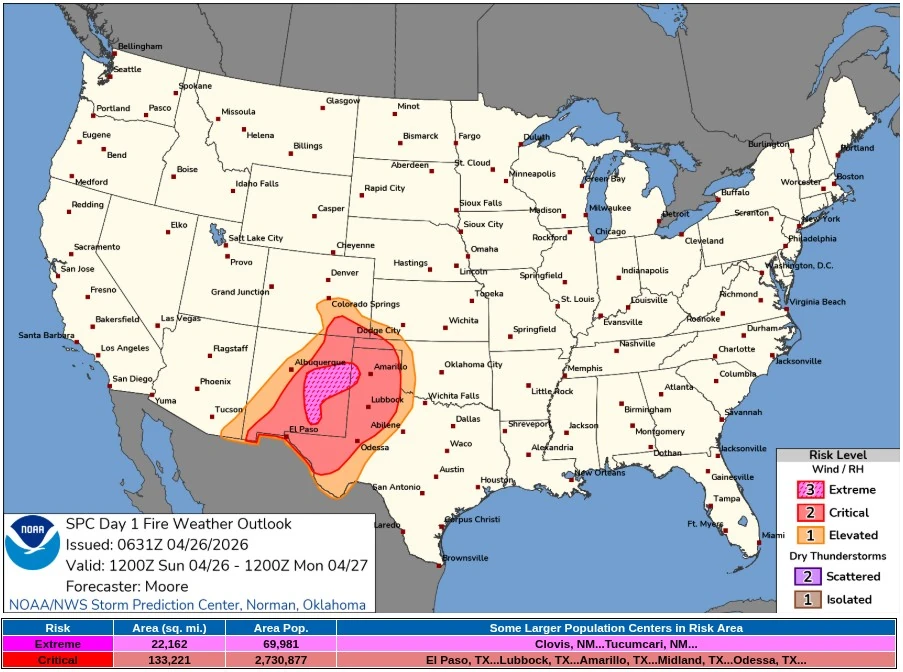
Storm Prediction Center’s (SPC) Day 1 Fire Weather Outlook, issued at 06:31 UTC on April 26 and valid from 12:00 UTC on April 26 to 12:00 UTC on April 27, placed 57 399 km² (22 162 mi²) in the Extremely Critical area, with 69 981 people exposed, including Clovis and Tucumcari, New Mexico. The broader Critical area covered 345 041 km² (133 221 mi²), with 2 730 877 people exposed, including El Paso, Lubbock, Amarillo, Midland, and Odessa, Texas.
A low-amplitude upper wave moving from the lower Colorado River Valley into the Southwest is forecast to push an attendant mid-level jet into the southern High Plains by peak heating. This setup will promote steady deepening of a lee cyclone across eastern Colorado and western Kansas, strengthening west/southwest winds across the southern High Plains.
SPC forecast widespread sustained winds of 30-40 km/h (20-25 mph) across the region, with gusts of 55-70 km/h (35-45 mph). A swath of 50-55 km/h (30-35 mph) winds is forecast across eastern New Mexico into far western Texas, under the approaching mid-level jet and in the lee of the Sacramento and southern Sandia Manzano Mountains, supporting a corridor of extremely critical fire-weather conditions.
A dry air mass has remained in place across the Southwest and southern High Plains for several days, with afternoon relative humidity minimums largely in the single digits to low teens. Increasing downslope warming and drying will lower humidity further this afternoon, with values most likely falling into the 5–10% range again today.
Light precipitation was ongoing early Sunday across northeast New Mexico and parts of the Texas Panhandle, but SPC said Multi-Radar/Multi-Sensor quantitative precipitation estimates showed little rainfall reaching the surface. Preceding dry and windy days, Energy Release Component values are largely near the 85th percentile, and receptive fuels will support the fire-weather concern.
NWS Albuquerque issued Red Flag Warnings for most of New Mexico, except the northern mountains and northwest plateau, from 11:00 MDT on April 26 to 20:00 MDT. The office forecast southwest gusts of 70-95 km/h (45-60 mph), minimum relative humidity of 10-15%, dry vegetation, and localized extremely critical conditions across parts of eastern New Mexico.
Red Flag Warnings also cover southwest and south-central New Mexico, West Texas, the South Plains, the Rolling Plains, the far southern Texas Panhandle, and the Texas and Oklahoma Panhandles. NWS offices in El Paso/Santa Teresa, Lubbock, Amarillo, and Midland/Odessa forecast gusts generally reaching 80-95 km/h (50-60 mph), minimum relative humidity falling to 8-15% in parts of the warned area, and dry to critically dry fuels.
NWS Midland/Odessa forecast Rangeland Fire Threat Index values of 6-8, or critical to extreme, across parts of southeast New Mexico, the Guadalupe to Davis Mountains, and much of far West Texas. NWS El Paso/Santa Teresa said Energy Release Component values are climbing to the 85th-90th percentile in its warning area.
Fuels remain dry and receptive across the southern Plains and New Mexico, with Energy Release Component values approaching the 90th percentile, according to SPC. The agency said recent and ongoing active fires across the Southwest and southern Plains could be affected by the dry and windy conditions forecast for Sunday.
The National Interagency Coordination Center’s April National Significant Wildland Fire Potential Outlook places much of the central and southern High Plains, most of New Mexico, and southeast Arizona under above-normal significant fire potential for April.
References:
1 Day 1 Fire Weather Outlook – NWS/SPC – April 26, 2026
I'm a dedicated researcher, journalist, and editor at The Watchers. With over 20 years of experience in the media industry, I specialize in hard science news, focusing on extreme weather, seismic and volcanic activity, space weather, and astronomy, including near-Earth objects and planetary defense strategies. You can reach me at teo /at/ watchers.news.
Commenting rules and guidelines
We value the thoughts and opinions of our readers and welcome healthy discussions on our website. In order to maintain a respectful and positive community, we ask that all commenters follow these rules.